Friday 25 May 2012

An Afternoon Wander down to Montrose Basin

Friday 25th May

Distance: 3.5km; Ascent: negligible; Sunny; with Lynsey & Isabel

We were spending an extra day in Angus after Lynsey finished the TGO Challenge yesterday.  Therefore after saying our goodbyes to various challengers we headed out for an afternoon stroll in the Montrose Basin Wildlife Reserve.

Entering the Montrose Basin Nature Reserve
It was sunny and warm as we set off from the Old Mill car park heading for the Shelduck Hide, initially along a narrow path but then along generally broad tracks.  We crossed a disused railway line and I wondered whether there was any potential of incorporating this into a future TGO Challenge route (as it seems pretty tricky to avoid the tarmac on the final day!)

Disused railway line
Shelduck Hide was deserted this afternoon, so we took a look inside.  However there appeared to few birds around this afternoon, but there were good views of the basin and the River South Esk.

Montrose Basin and viaduct from Shelduck Hide
River South Esk from Shelduck Hide
We returned to the car park the same way, before heading back to our cottage to the east of Brechin for our final night in Scotland of this trip.

Heading away from the basin
Written up in January 2013 from photos and memories

Thursday 24 May 2012

St Cyrus and the end of the 2012 TGO Challenge

Thursday 24th May

Today was the day that Lynsey would be finishing her 3rd TGO Challenge, and Isabel & I planned to meet her at St Cyrus.  Therefore after finding a parking spot in the village, I wandered down to the beach with Isabel on my back in her rucksack carrier.  Around 30 minutes later Lynsey arrived with Alan and Andrew, and as you can read more about it on her blog I've just included a few photos below:

St Cyrus
Descending to St Cyrus beach
St Cyrus beach
TGO Challengers on St Cyrus beach
On St Cyrus beach

Written up in January 2013 from photos and memories
 

Wednesday 23 May 2012

Lunan Bay and the House of Dun

Wednesday 23rd May

Total distance: 5.5km; Negligible ascent; Sunny; with Isabel, Mum & Dad

After yesterday's day hill walking, today was spent enjoying a couple of short strolls with Isabel and my parents in the Montrose area.  With low tide late morning and another day of fine weather in store we decided to head for Lunan Bay, which is where I finished my last TGO challenge back in 2010.

Lunan Bay beach
We set off walking from the car park at around 10:45am, with me carrying Isabel in her rucksack carrier.  The sand was warm underfoot as we made our way through the dunes and down onto the beach itself, which was almost deserted with only a handful of other people around.  There were some interesting trails in the sand and we also spotted a jellyfish.

Patterns in the sand at Lunan Bay
Jellyfish at Lunan Bay
We continued northward up the long beach to reach some fishing nets set up on the beach, presumably to trap fish at high tide.  Eventually we reached the rocks at the far end of the beach, where there was a natural arch in the cliffs, and Isabel had fun running around the rocks and playing with the sand.  We then headed back the car, with a detour to take Isabel down to the sea.

Fishing nets at Lunan Bay
Lunan Bay
We headed to the House of Dun for a spot of lunch in the cafe before heading off for a wander around the grounds with Isabel in her ATP.  Initially we wandered along a grassy path through the woods to the east and north of the house.  There were good views to the Montrose Basin from the NE corner of the woods.

Carpet of white flowers in House of Dun woods
We continued on through the woods, which were complete with a white carpet of wild flowers that I was unable to identify.  We then headed into the gardens, which were apparently a rabbit control area; although I'm not too convinced that this simple gate was going to stop them!
 
Rabbit control area!
After wandering around a small valley covered in a wide array of plants, we climbed up the small slope on the far side to reach the walled garden.  Here we found the only remains of the original Dun Castle: an archway standing alone on one side of the garden.  Soon afterwards we came across the remains of the old parish church of Dun.

Archway is all that remains of the original Dun Castle
Old parish church of Dun
We descended back down into the small valley, passing the ice house on route, to cross the river on a bridge high above the valley floor.  After a brief wander through Lady Augusta's rockery we reached the formal gardens outside the house itself, before heading back to the tea room for tea and cake and a pleasant couple of short strolls.

In the gardens of the House of Dun
The House of Dun

N.B. 30/10/12 - Post date updated to actual date of walk, i.e. 23/05/12, (from 30/05/12)

Tuesday 22 May 2012

Driesh and Mayar from Glen Doll

Distance: 15km; Ascent: 980m; Sunny and dry with light winds; Solo

Now that the weather had drastically improved, I was itching to get out walking in the hills.  My parents kindly offered to look after Isabel for the day today and so at 10:30am this morning I found myself setting off walking from the Forestry Commission car park at the road head in Glen Doll.

The Kilbo Path was well signposted from the main forestry track and I was soon ascending up the wooded hillside on a good path; the ground around the path was festooned with wild flowers, which I struggled to identify.  It was already very warm in the sunshine and I was soon stopping for a drink of water!  The path now entered a welcome shady area where it was pleasantly cool amongst the trees.

Flower in Glendoll Forest
Upon reaching the edge of the forest I happened upon a large group of twenty or so walkers who had stopped for a break; I guessed that they must have been here for a while as they had left the car park some 20 minutes before me.  I continued on up the good path that traversed the side of the Shank of Drumfollow to reach the bealach between Mayar and Driesh.  I began to climb the initial slopes of Driesh, from where there were excellent views back down the corrie and over towards Mayar.  Soon afterwards I spotted my first mountain hare of the day.

Mayar from western slopes of Driesh
I continued on up on a reasonable path to reach the summit of Driesh (Munro, HuMP) at around 12:15pm, which was marked by a trig point surrounded by a windshelter cairn.  Here I had a well earned lunch whilst chatting to a guy from Blairgowrie who was out for a walk with his dog.  There were excellent views in all directions, especially towards the Lochnagar hills and eastwards to Mount Keen.
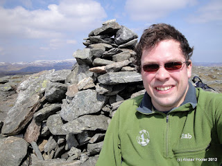
Summit of Driesh
Shank of Drumfollow in front of Glen Doll, with Lochnagar beyond
I took a slight detour on descent so that I could get better views into upper Glen Doll, but then rejoined my outward route, which I followed back down to the bealach.  There were good views over to the Shank of Drumfollow and down into the corrie.  As I ascended up the slopes on the far side of the bealach, I caught sight of my second mountain hare of the day.

Corrie of the Burn of Kilbo
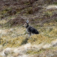
Mountain Hare near the Kilbo Path
The clear path led onwards towards Mayar and I soon reached the path junction where the Kilbo path begins its descent down into Glen Prosen.  However my route lay eastwards over the easy high ground towards my second hill of the day: Mayar.  A few hundred metres before the summit I spotted a pair of ptarmigan flying low over the ridge.  After that I soon reached the summit of Mayar (Munro, HuMP), which was marked by a large cairn.  Hear I met a German walker who commented that the weather was somewhat better than he had experienced in Glen Coe the previous week!

Remains of signpost indicating junction of Kilbo Path
On summit of Mayar
After taking in the views I began my ascent to the north, but then I spotted a figure heading this way from the direction of Tom Buidhe.  It looked like they had a backpacking sack on, so it was a fair bet that there were highly likely to be a TGO challenger and as I got closer it turned out that it was John B.  We stopped and chatted for 20 minutes or so about his route, Sunday night in Lochcallater Lodge and trekking in the Pyrenees!
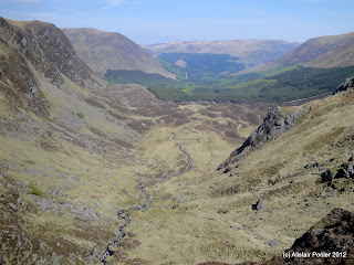
Upper Corrie Fee
After leaving John to continue with his ascent of Mayar, I began to drop down into Corrie Fee, which looked quite spectacular.  There were good views out over the corrie to the forest and the hills beyond.

Looking ESE out over Corrie Fee
I followed the good path as it meandered down past several impressive waterfalls and many wild flowers to reach the floor of the corrie.  From here the path followed a line of moraine across the corrie floor to reach the upper edge of the Glendoll Forest.

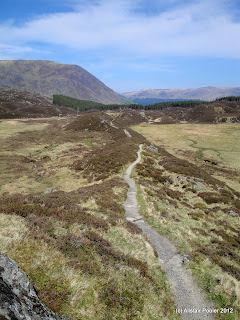
One of many waterfalls in Corrie Fee Path in Corrie Fee
Shortly after entering the woods, I crossed a burn to follow a broad footpath downhill to reach a forest road that I followed all the way back to the car park, arriving shortly before 4pm.  It had been an excellent day's hillwalking, with a further two Munros ticked too :)

Monday 21 May 2012

Scurdie Ness

Monday 21st May

Distance: 4.5km; Ascent: negligible; Dry but often overcast; with Isabel, Mum and Dad

After having left Lynsey to continue her walk up to Lochcallater Lodge yesterday afternoon, Isabel and I drove to Brechin where we met my parents at the cottage we will be staying at for the rest of the week.  This morning we headed into Montrose to drop a few things off at TGO Challenge Control, at the Park Hotel, and to say hello to John, Steph and Jack.  It was very strange being in Challenge Control when it was so empty and quiet; all my previous visits have been on the 2nd Thursday of the Challenge when it's usually packed full of challengers having just finished!

A short drive brought us to the beach front car park in Montrose where we had a picnic lunch in the car, whilst admiring the views across the bay.  Unfortunately it was pretty much high tide so we weren't able to go down onto the beach, but I'm sure we will before the end of the week.

Scurdie Ness from the north
A pushchair walk was in order for this afternoon so that Isabel would be able to have a nap.  Having previously finished the TGO Challenge at Scurdie Ness back in 2009, I reckoned that we'd be able to manage an hour or two's walk with the ATP.  Therefore we drove around to the old fishing village of Ferryden, so called because it was the location of an ancient ferry crossing over the river South Esk.  We parked in the small free carpark near the far end of the village and began our walk soon after 1:30pm.

Scurdie Ness lighthouse
We began by following Rossie/Beacon Terrace eastwards out of the village to the end of the public road.  Here a surfaced private road continued above the small cliffs, with good views onwards to Scurdie Ness lighthouse and back towards Montrose.

Looking back towards Montrose from Scurdie Ness
There were many birds on the estuary, although most of them were too far away to see reliably without binoculars; however we did get to see quite a few eider ducks relatively close up.

An Eider Duck
Soon we reached the lighthouse at the end of the Scurdie Ness headland, which was also the end of the private road.  According to the information sign, the lighthouse is 39m tall, was designed and built by David and Thomas Stevenson, and became operational in 1870; however it has been operating automatically since 1987.

Scurdie Ness Lighthouse
As well as the lighthouse, there is another landmark of importance at Scurdie Ness, especially for TGO Challengers!  It is the TGO Challenge cairn that was erected here on the 25th anniversary of the Challenge back in May 2005, and it is here that Lynsey & I finished our 2009 route.

TGO Challenge cairn at Scurdie Ness
The grassy footpath beyond the lighthouse was signed to Mains of Usan, and it looked to easily be achievable with an ATP, so we continued on around the headland.  We took it in turns to scramble down the rocks to get a better view of a couple of rafts of eider ducks and to have a look at some of the interesting rocks on the headland.

Looking south from Scurdie Ness
However it soon became clear that the onward route would cross several muddy sections on the way to Mains of Usan, which whilst they would probably be crossable with an ATP we decided that due to lack of time it would probably be better to return the way we came.  As we started to head back to Ferryden, a large ship started to leave Montrose harbour as it was now pretty much high tide.  After a pleasant walk back to Ferryden, we reached the car at around 3:15pm and headed back into Montrose to adjourn to a tearoom :)

A large ship leaving Montrose

N.B. 30/10/12 - Post date updated to actual date of walk, i.e. 21/05/12, (from 27/05/12)

Sunday 20 May 2012

A Short Stroll in Glen Callater

Distance: 2.5km; Negligable Ascent; with Lynsey & Isabel

As Lynsey was taking part in this year's TGO Challenge, I had driven up to meet her in Braemar yesterday morning with Isabel, after our overnight halt at Cumbernauld on route.  After meeting her, we had a leisurely afternoon in town with Isabel having fun running around the Highland Games park.  Then later that evening, Lynsey went out to enjoy the festivities at the Moorfield House Hotel.

We spent the morning in Braemar meeting various TGO challengers, before having lunch at The Old Bakery.  At around 1:30pm Lynsey hoisted her pack onto her back and headed south along the A93.  Around half an hour later Isabel and I drove up the road to the car park at Auchallater to wait for her.  After a snack of home-made chocolate buns, we set off walking along the vehicle track up Glen Callater with me carrying Isabel in the rucksack carrier.

Beinn a'Bhuird and Ben Avon from bottom of Glen Callater
The weather was much better than yesterday, and according to Lynsey it was easily the best day of weather so far on this year's crossing.  There were excellent views over towards the snow covered eastern Cairngorms, and we could pick out some of the tors of Ben Avon; there were also good views up Glen Callater.

Creag na Dearcaige above Glen Callater
We continued up the vehicle track to where the glen curves around to the south; here Isabel got down and did a spot of walking under her own steam for a few hundred metres, interspersed with splashing in every puddle possible!

Callater Burn
Soon it came to the time for Isabel and I to part company with Lynsey, who was heading further up the glen to camp outside Lochcallater Lodge for the traditional evening's merriment!  Isabel and I however, had to turn around and head back down the glen.

Looking down Glen Callater towards the eastern Cairngorms
On the way back to the car we passed several groups of challengers heading for Lochcallater Lodge, including Ian C, Andrew W and Alan S.  We reached the car at around 4:15pm and after a picnic tea for Isabel we headed for Brechin where we will be staying for the rest of the week.

Friday 11 May 2012

A Spectator of the TGO Challenge 2012

Camping at the Shieling E of Loch Calavie on the 2009 TGO Challenge
This morning marked the start of this year's TGO Challenge, a two week coast to coast backpacking event across Scotland.  Having taken part three times myself, in 2008, 2009 and 2010, I can confirm that it is indeed excellent.  However, this year I shall be an envious spectator as Lynsey is taking part instead.

Lynsey has an interesting route planned from Lochailort on the west coast to Johnshaven on the east coast, and depending on phone signal she may do a spot of blogging on route.  You can see her route on this live map (or on the full size version); the pink line is her planned route, which should get overlaid with beacons from her actual route whenever she has phone signal (which may not be that often, so don't worry if there are long gaps between beacons!)

Just over a dozen other challengers are also making their progress available online via the SPoT and Social Hiking sites.  And of course some of them will be blogging too, which are likely to include Alan S and Martin B amongst others.

I wish everyone the best of luck on their crossings and hope that the weather is kind to you all!  I plan to be in the eastern highlands for the last week of the challenge to meet Lynsey in Braemar and Johnshaven, which I am of course looking forward too! :)

Sunday 6 May 2012

Solomon's Temple

Sunday 6th May

Distance: 2.5km; Ascent: 80m; Sunny; with Lynsey, Isabel, Jim, Rachel, Edward, Rebekah, Adam, Laura & Heather

Some friends of ours were staying in Buxton for the bank holiday weekend so we met up with them for a morning wander around Buxton Country Park.  We climbed to the top of Solomon's Temple (also known as Grinlow Tower) and admired the good views of the surrounding area.  There also seemed to be some sort of OS trig point bolt on the tower's viewing platform.  Afterwards we took a stroll through the woodland to the north before returning to the car park after a pleasant morning.

View over Buxton from the top of Solomon's Temple
Looking towards Axe Edge from Solomon's Temple
OS Trig Point Bolt
Solomon's Temple
Written up in January 2013 from photos and memories