Friday 12 October 2012

An Autumnal Lochaber Backpack - Index

Last weekend I had a couple of excellent days backpacking in Lochaber doing a spot of Munro bagging.  With a reasonably good weather forecast coinciding with a free weekend, I jumped at the chance to have another hill walking trip to the Highlands and booked some train and bus tickets up to Fort William.

The weather was excellent and I got a view from the top of every hill I climbed :-)  I saw plenty of people in the Mamores on Saturday, but only a couple of other backpackers on Sunday.  My route for Saturday turned out to be somewhat ambitious given that I couldn't get to Glen Nevis before 10:30am and it gets dark around 6:30pm.  However this proved to be a blessing in disguise as it meant I had the option of a high camp instead of my planned valley camp, and what a spot I chose to camp!  It was easily one of the best places I've pitched my tent for some time.  I shall have to camp high again soon!

Camp on the east ridge of Stob Coire a' Chairn, just below the summit
This post is an index of my blog posts on the trip, which I have updated to include more photos and maps of my routes, and there's also a link to more of my photos from the weekend, my original plans and my Social Hiking map from the trip.
  • Original slightly ambitious plans for the weekend
  • Day 1 - Glen Nevis to Stob Coire a' Chairn
  • Day 2 - Stob Coire a' Chairn to near Corriechoille
  • Photos from the trip (geotagged)
  • Social Hiking map, with occasional tweets and photos

Sunday 7 October 2012

An Autumnal Lochaber Backpack: Day 2 - Stob Coire a' Chairn to near Corriechoille

Sunday 7th October

A fantastic long day over some fairly remote hills.

Distance: 23.5km, Ascent: 1440m; Mainly dry and clear with a cold wind and occasional squally showers; Solo

I stirred a couple of times during the night owing to the tent flapping in the wind.  There seemed to be 15 minutes or so of during winds followed by calm, and it seemed to go on like this through the night (well at least the bits that I was awake for anyway!)  I woke up shortly after 6 to find confirmation that it had been cold last night: I had frost on my tent.  Although I had already guessed that it had got down to freezing owing to the amount of clothes I had to wear inside my sleeping bag to stay warm.  Time to dig out my winter bag when I get home methinks!

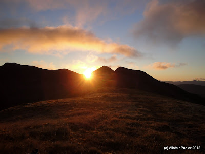
Sunrise at 7:45am over Na Gruagaichean in the Mamores
At around 6:30am I poked my head outside the tent to see the red glow of dawn behind Na Gruagaichean, my first peak for the day.  I got the stove on and was soon having coffee and porridge whilst watching dawn's progress.  However it was still quite cold so I unfortunately had to do the tent tent back up to get warm again!  I read for a bit before packing up and heading outside into the morning sun.  A bit of photography then followed to take advantage of the fantastic morning light, before I struck camp and packed my bag.

Early sunlight at 7:45am on Am Bodach - taken from my tent door :-)
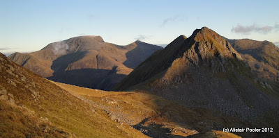
Ben Nevis, Carn Mor Dearg and An Gearanach from E ridge of Stob Coire a' Chairn
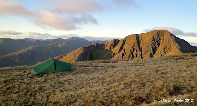
Morning view of my overnight stop in front of Am Bodach
I set off walking just before 8:30am and descended the pleasant ridge to the southeast, glad that I hadn't camped any further down as the sun hadn't reached there yet!  A steep climb brought me to the northwest top of Na Gruagaichean (Munro Top).  The continuation to the main summit was rocky in places, and I remembered that it was somewhere around here that I first had to use my ice axe in anger to arrest a slip back in the winter of 2001.  At around 9:30am I reached the summit of Na Gruagaichean (Munro), which unsurprisingly given the hour I had to myself.

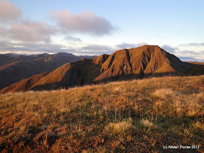
Am Bodach and Stob Coire a' Chairn from the east
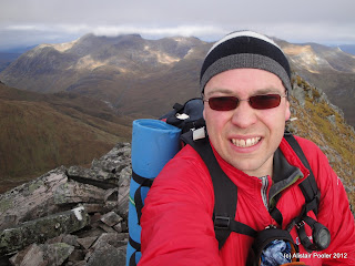
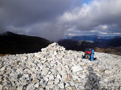
Summit of Na Gruagaichean
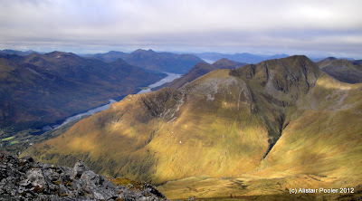
Loch Leven and Am Bodach from Na Gruagaichean
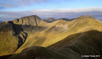
The views were excellent in all directions, including along the length of Loch Leven and, in the other direction, across towards the Ben Alder hills in the distance.  A fine ridge brought me to the south top of Binnein Mor (Munro Top) and then onwards to my highest point this weekend, the main summit of Binnein Mor (Munro, Marilyn) at 1130m.  The views from here were again impressive, especially over towards Binnein Beag and the Grey Corries.

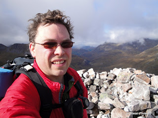
On the summit of Binnein Mor
Binnein Beag and the Grey Corries
The northeast ridge looked to be quite steep and scrambly, which I didn't fancy with a big pack on.  Instead I opted to descend the north ridge for a few hundred metres before picking up a traversing path into the corrie.  Unfortunately the path soon petered out, leaving me with an unpleasant descent down steep slippy grass down to the bealach.  I had a minor slip on the way down, during which I must have applied a lot of force to my walking poles as I managed to bend one of them!  Although I was unscathed myself :-)

A steep ascent up scree and rock from the bealach brought me to the summit of Binnein Beag (Munro, Marilyn) at around quarter to midday.  This seemed as good a place as any for lunch, so I stopped here a while to admire the amazing views.  Looking at my map I concluded that it was approximately the same distance to walk out to Spean Bridge as it would be to walk down Glen Nevis to Fort William but the former option offered the chance to bag another Munro: Stob Ban.  This sounded like a good idea and so after lunch I descended the north side of Binnein Beag, which is not to be recommended due to the horrible steep scree and rocks!

On the summit of Binnein Beag
After heading across a boggy area I eventually reached the Abhainn Rath, which was a welcome sight as I had run out of water on the summit of Binnein Beag!  I took a brief break here for food and water, whilst I planned my ascent of Stob Ban.  The direct route via Meall a' Bhuirich looked to be unpleasantly steep to begin with.  I therefore opted to follow the burn up into Coire Rath, with the aim of ascending Stob Ban via the bealach to its north.

The walk up the corrie was pleasant enough and I was accompanied by the roaring of stags all around me.  At around 500m altitude, my plan became somewhat unstuck!  During my hurried look at the map earlier I had failed to spot that the for the next few hundred metres the burn I was following would be in a bit of a narrow steep sided valley.  Therefore there was only one thing for it, which was to take a more or less direct line up the steep ground to the summit!

Summit of Stob Ban
After a long slog, past a group of ptarmigan, I reached the summit of Stob Ban (Munro, Marilyn) soon after 3:30pm.  By now it was clear that I was going to struggle to make it to Spean Bridge in time for the bus at 6pm, which I needed to catch in order to make my bus south from Fort William at 7pm.  Therefore, taking advantage of the phone signal on the summit, I rang up a local taxi company and arranged to be picked up from the end of the road at Corriechoille.  This would save me around 45 minutes, but it was still a long way to go!  So after a quick break on the summit to admire the views one last time, I began my descent.

Cruach Innse and Sgurr Innse
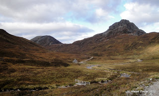
There was a reasonable path down much of the east ridge, which brought me down to a nice looking bothy at the end of a vehicle track.  I picked up my pace and ascended over the wide pass and down the far side into the woods.  Soon I stumbled soon The Wee Minister statue alongside the track, and soon afterwards an unexpected carpark.

Looking down the Allt Leachdach
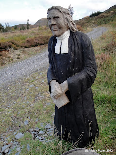
The Wee Minister
I continued down the track as fast as I could and a few minutes after passing the carpark a car stopped and offered me a lift down to the road, which I gladly accepted.  Soon I was in my taxi back to Fort William, where I just had enough time to grab some food and hop on the bus to Glasgow.  It had been an excellent weekend in the hills :-)

N.B. This was sent from my phone.  At some point during the next week I will be editing this post to include more photos and a route map of the day's walk.  Post updated on 12/09/12 to include route map, photos and links to hills; post date also altered to actual date of walk (from 08/10/12).

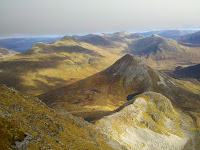
Mobile phone photo of Binnein Beag, uploaded whilst on walk

Saturday 6 October 2012

An Autumnal Lochaber Backpack: Day 1 - Glen Nevis to Stob Coire a' Chairn

Saturday 6th October

An excellent day's walking in the Mamores, taking in three Munros (two of which were new ones for me).

Distance: 14km; Ascent: 1800m; Mainly dry with occasional sunshine; Solo

After an evening train journey up to Glasgow last night, I arrived at the Premier Inn that I had booked to find that it was very new, having only been open since Monday!  I sorted out my backpacking gear and headed to bed.  This morning I made an early start at 6am, dropped off my non-backpacking stuff in the luggage room, and wandered across the road to catch the first bus of the day to Fort William.

A three hour bus journey then followed, with intermittent snoozes and also some spectacular views at times!  I arrived into Fort William just before 10am and after a quick trip to the supermarket for last minute supplies, I got a taxi up Glen Nevis to the Lower Falls carpark, which was the starting point of my walk today.

Rainbow and Ben Nevis
The first half hour or so was relatively easy on gentle angled forest tracks.  After that I picked up a newish looking path up through an area of felled forest.  Around now it began to drizzle; however this was relatively short-lived and also resulted in an impressive rainbow above the glen.  Soon it was time to leave the woodland, and the good path at a stile onto the boggy open hillside.

Morning cloud over Sgurr a'Mhaim
Looking down into Glen Nevis from NW ridge of Mullach nan Coirean
I headed steeply up onto the northeast ridge of Mullach nan Coirean.  The ground improved as I ascended, as did the weather resulting in fantastic views :-)  I continued up the well defined ridge, which became rockier higher up around the time I entered the cloud, which was hanging at around 800m.  Just before 1pm, I reached the summit of Mullach nan Coirean (Munro) a little short of two and a half hours after leaving Glen Nevis.

On the summit of Mullach nan Coirean
Whilst I was having lunch in the shelter of the summit cairn, the cloud suddenly lifted to reveal a most impressive view across Loch Linnhe and over to the hills of Ardgour.  A couple of other hill walkers arrived just as I was about to leave, so I wished them a good day and descended along the ridge whilst admiring the views of where I would be heading next.

Looking across Loch Linnhe towards the Ardgour hills from summit of Mullach nan Coirean
The undulating ridge headed over the southeast top (Munro Top) and the east top (Corbett Top), and past a few other walkers, to reach the impressive quartzite peak of Stob Ban.  The wind was strong enough to make it chilly at times, but not so strong as to cause any balance issues!  I reached the summit of Stob Ban (Munro, Marilyn) at around 2:30pm, and it was here that I first had my doubts as to whether I was going to have enough daylight to complete my planned route for the day.

Stob Ban from the SE top of Mullach nan Coirean
Summit of Stob Ban
The descent from Stob Ban was steep and tricky to start with, but soon I was on the pleasant east ridge down to the bealach from where there were good views down towards Glen Nevis and southwards towards the West Highland Way.  A short, sharp ascent brought me to the summit of my next hill: Sgorr an Iubhair (Munro Top), which I reached at 3:45pm.

Stob Ban from the east
The Devil's Ridge and Sgurr a' Mhaim from Sgorr an Iubhair
It was now clear that I was somewhat behind schedule, so I opted to skirt the next peak, Am Bodach to the north by way of a stalkers path.  As I traversed I could hear stags roaring in the corrie below.  Around halfway through the traverse I came upon a pleasant surprise: an unexpected stream!  Taking the opportunity to collect water for my camp, I filled up my containers with three litres; now I would be able to camp up high on the ridge whenever I fancied.

An Gearanach from Stob Coire a'Chairn
A pleasant ridge, over the south top (Corbett Top), brought me to my third Munro of the day: Stob Coire a' Chairn (Munro, HuMP).  The views were excellent from up here and I could pick out most of the main peaks in Lochaber.  However it was now 5:20pm, which left me with only 1-1.5 hours of daylight left.  A summit camp would have been nice, but it was too stoney here.  Therefore I continued along the ridge to the ESE, where I soon came upon a flat grassy area with excellent views.  This seemed like an ideal camp spot, so I got the tent out and just about got it pitched before a squally shower arrived!

Binnein Mor and Na Gruagaichean from Stob Coire a' Chairn
Camp on the east ridge of Stob Coire a' Chairn, just below the summit
Once the shower had passed, I reopened the tent to admire the excellent views whilst I boiled water using a convenient rock in porch as a table!  Dinner was couscous, which I ate whilst listening to last nights News Quiz.  The temperature dropped significantly once it got dark and I was soon tucked up warmly in my sleeping bag for the night.  A wee dram of Glenlivet and a hot chocolate then followed, whilst I caught up on some of the other outdoor blogs that I follow using an offline reader on my phone.

Cooking at dusk

N.B. At some point during the next week I will be editing this post to include more photos and a route map of the day's walk.  Post updated on 11/09/12 to include route map, photos and links to hills; post date also altered to actual date of walk (from 07/10/12).

Mobile phone photo of the Mamores ridge, uploaded whilst on walk

Friday 5 October 2012

Backpacking in Lochaber

This weekend I'm off backpacking again, this time in the Mamores and surrounding area in the Western Highlands.  I had hoped to take the sleeper train up to Fort William but it's fully booked, so instead I'm off to Glasgow this evening and then the morning bus to Fort William the following day.

My plans are somewhat fluid, with the main aim of the trip being to bag my last four Munros in the Mamores (two at each end of the main ridge), so that'll be my plan for tomorrow.  Then depending upon where I end up camping tomorrow evening, I may walk out to Spean Bridge over the Grey Corries.  Here's the distance and ascent for the two days, assuming that I camp around the watershed at the east end of Glen Nevis:
  • Day 1 - Glen Nevis Lower Falls to east end of Glen Nevis via the main Mamores ridge: 19km, 2080m ascent
  • Day 2 - East end of Glen Nevis to Spean Bridge via the Grey Corries: 23km, 1160m ascent
The following Social Hiking map shows my planned route (in pink), which should get overlaid with my progress (in orange) assuming I have phone signal!  I'll also be sending daily blog posts when I have signal too.

See map on Social Hiking site or full size in a new window