Sunday 24 February 2013

Aira Force

Sunday 24th February 

A short waterfall walk near Ullswater 

Distance: 2.5km; Ascent: 110m; Dry & cold; with Lynsey & Isabel


Our planned ascent of Little Mell Fell was abandoned before we had even reached the bottom of the hill due to snow covered roads!  Therefore we instead went for a low level stroll near Ullswater to take a look at Aira Force.  After parking in the National Trust carpark we set off walking at around midday on a good path.  Soon we crossed to the east side of the beck and a few hundred metres later we reached the bridge at the bottom of the falls.

Aira Force
This spot was quite dramatic, with the very impressive waterfall and the spray having frozen on the the surrounding rocks.  After admiring the falls we continued along the path up the east side of the beck (as the steps up to the path on the west side were closed due to a landslide).  We ascended up to the top of the falls to reach another bridge, from where you could look directly down on the main fall.

Aira Force
Above Aira Force we continued following the rocky path on the east side of the beck, with good views down to the beck itself, to reach the bridge at High Force where the beck ran through a narrow gorge.

Aira Beck above Aira Force
After a quick break at High Force we crossed to the west side of the beck and followed the good path back southwards towards the carpark with good views down to Ullswater and the surrounding fells.  We returned to the car at around 1:30pm and after a picnic lunch we headed home after a good weekend in the Lakes; stopping at Tebay services on the way home for tea and cake :-)

Looking south over Ullswater
N.B. 02/06/13 - Post date updated to actual date of walk, i.e. 24/02/13 (from 27/02/13) 

Saturday 23 February 2013

A Pushchair Wander In Glenridding

Saturday 23rd February

A pleasant afternoon stroll in the wintry Glenridding valley

Distance: 7km; Ascent: 200m; Cold, overcast with snow showers; with Lynsey & Isabel


We were away in the Lake District, staying at Helvellyn youth hostel in Glenridding, for a weekend of short strolls (well you can only walk so far with a toddler!) We woke to persistent falling snow, although not much of it appeared to be settling down in the valley; therefore we decided to head out for a bit of a wander with the ATP from the hostel.

After a bit of a late start we headed off west up the valley to see how far we could get. We passed a bunkhouse with several RAF Mountain Rescue vehicles outside (presumably they were training in the area) before reaching a bridge over the river a short distance beyond, with good views upstream to the wintry hills beyond.


Looking up Glenridding Beck

Looking back down Glenridding Beck towards the youth hostel
It would have been nice to continue further up the valley, but due to the amount of ice on the path this seemed a bit unwise. Therefore we returned to the hostel for lunch before following Greenside Road down the valley, with good views of the nearby hills.


Looking up Glenridding from Greenside Road
We continued down into Glenridding village, where we stopped for a break in the Ramblers' Bar complete with a welcome pint of ale :-) There were good views of Place Fell across the lake from the village.


Place Fell above Ullswater
After feeling suitably refreshed we briefly browsed the few shops (picking up essentials such as milk & beer!) Then we walked back up the steep road towards the hostel, where we arrived late afternoon after a pleasant day.

N.B. 02/06/13 - Post date updated to actual date of walk, i.e. 23/02/13 (from 24/02/13) 

Saturday 16 February 2013

Early Spring at Dunham Massey

Well after yesterday's snowy walk in the Coniston Fells, today we went for a wander around Dunham Massey's winter garden. There were plenty of snowdrops out, along with a few daffodils with plenty more on the way - so it looks like Spring is around the corner!


Friday 15 February 2013

A Snowy Day in the Coniston Fells

Friday 15th February 

A mainly misty walk up Coniston Old Man with fantastic views in the afternoon once the cloud cleared

Distance: 15km; Ascent: 990m; Misty on the summits; with Peter & Gary


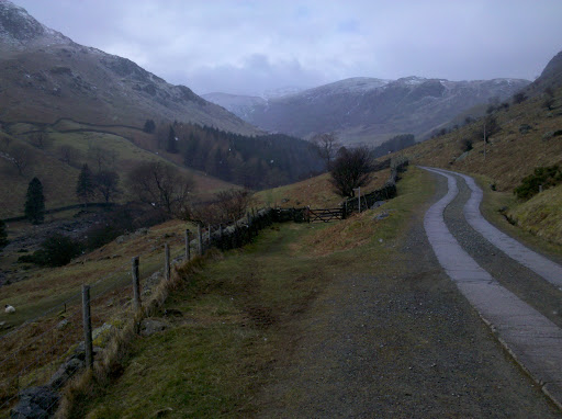
I had the day off work today and for once the weather forecast actually looked good! Therefore I decided to go hillwalking :-)   A discussion on Twitter last night resulted in me driving up to Coniston this morning to meet Peter and Gary at the high carpark on the Walna Scar Road. We had chosen this start point to give us a bit of height advantage due to the fact I couldn't get there much before 11am.

We set off walking under mostly overcast skies, with the tops of the peaks covered by the cloud. There was a bitter, brisk wind blowing as we followed the Walna Scar Road WSW below the southern slopes of The Old Man of Coniston. It had been a number of years since my last visit and in the meantime the Walna Scar Road had clearly had some significant improvement works; it was also interesting to note that it's also been reclassified as a bridleway.

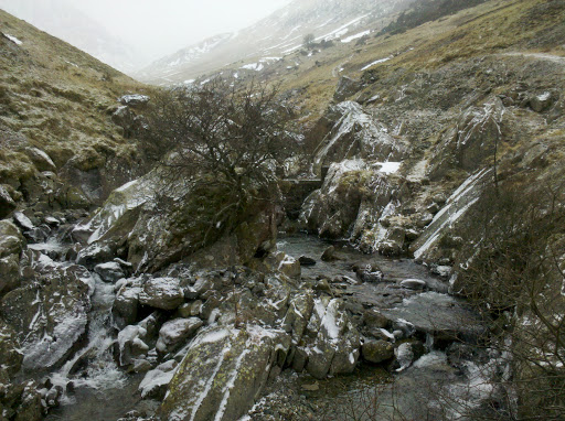
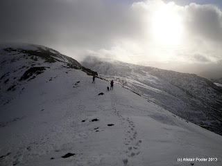
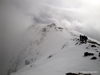
Looking up to the south ridge of The Old Man of Coniston
We followed the Goat's Water track for a few hundred metres before heading off rightwards towards the southern ridge of Coniston Old Man. The cloud intermittently cleared briefly to reveal glimpses of the blue sky above and the cloud free Eastern Fells - clearly we should have gone walking there!  Heading on up the south ridge, into the cold wind, we were soon walking on snow, most of which was pretty soft. At around 12:30pm we reached the summit cairn on The Old Man of Coniston (Nuttall, Marilyn, Wainwright, Birkett), together with the nearby trigpoint.

Snowy, misty summit of The Old Man of Coniston
We stopped in the lee of the cairn for lunch, before descending the north ridge. Around five minutes after we left the summit the cloud briefly cleared to allow us a glimpse back up the ridge to the summit.

A brief break in the clouds on the north ridge of Coniston Old Man
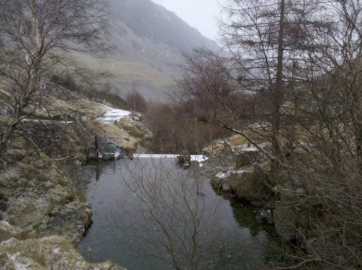
Heading towards Levers Hawse
Heading onwards across the soft, slushy snow we soon reached the large cairn on the summit of Brim Fell (Nuttall, Wainwright, Birkett). After descending to Levers Hawse, from where we briefly saw Levers Water, we began to traverse the steep slopes of Swirl How. The snow here was noticeably firmer in places so my ice axe was removed from my bag and placed in the somewhat more useful location of my right hand!

After a little over a kilometre of traversing we reached the col to the west of Great Carrs and then an eighty metre ascent brought us to the two cairns on the summit of Grey Friar (Nuttall, Wainwright, Birkett).

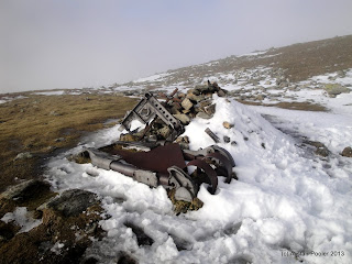
Remains of Halifax Bomber, which crashed here on 22/10/44
After resting for a few minutes we retraced our steps back down to the col, before ascending up towards Great Carrs. Soon we stumbled upon some of the remains of a Halifax Bomber, which crashed here in 1944, together with a memorial cairn. The sun was now starting to break through the clouds and after a little bit more ascent we reached the ridgeline. Here we were in for a treat as the combination on sunshine and cloud on the east side of the ridge resulted in a Brocken spectre!

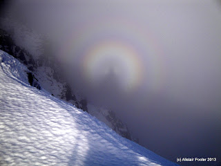
Brocken spectre between Great Carrs and Swirl How
It was lucky that I had my camera on my chest strap as within a minute of taking this photo the sun went back behind a cloud and the Brocken spectre disappeared! I think this was only the second time I'd seen such a phenomenon. There were also good views along the ridge in both directions!

Swirl How
We briefly detoured to the north to visit the summit of Great Carrs (Nuttall, Wainwright, Birkett) before heading on to the summit cairn of Swirl How (Nuttall, HuMP, Wainwright, Birkett), which was half covered in hoar frost. By now the cloud had returned and a little bit of navigation was required to locate the small summit of Great How Crags (Birkett), which was a new peak for me.

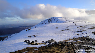
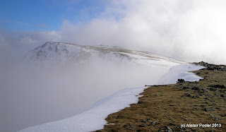
Finally the cloud lifts as we head back towards Coniston Old Man
As we followed the ridge southwards, the cloud began to clear again so we decided to head back up The Old Man of Coniston in the hope of getting a good view of sunset over Dow Crag.  There were excellent views down to Levers Water and Seathwaite Tarn as we continued to follow the ridge, as shown in the following few photos:

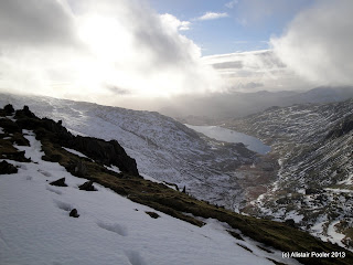
Levers Water with Coniston Water in the distance
Seathwaite Tarn
Old Man of Coniston
Summit of the Old Man of Coniston
We reached the summit again at around 4:20pm, with significantly better views than when we were there four hours previously!  Unfortunately a further bank of cloud was heading in from the west, which didn't look like it was likely to clear before sunset.  Therefore we headed back down the south ridge, with good views over to the snow covered Eastern Fells.  We reached the car park at 5:30pm after another good days hill walking; and it was good to meet more new people :-)

More photos from the day can be found here and also here's a link to my Social Hiking map from the walk, complete with tweets and photos from the day.

N.B. 02/06/13 - Post date updated to actual date of walk, i.e. 15/02/13 (from 20/02/13) 

Sunday 10 February 2013

Recent Walks and Future Plans

Due to various reasons I didn't get much walking done in December and January; however this has now been rectified by two walks over the last week!  Last Sunday I had a surprisingly enjoyable walk from Stockport to Manchester along an old railway line and the towpath of the Ashton Canal with John and Viv.  And yesterday I had a excellent day in the Shropshire Hills meeting new people :)  Write-ups of these walks will appear at some point in the next week or so, i.e. when I get round to it!

After the disappointment of not getting onto this year's TGO Challenge, I've been starting to make some alternative plans for the spring instead.  Currently I'm thinking of doing a spot of Munro bagging in the Central Highlands & Cairngorms, together with a trip to Arran.  There'll be some backpacking too; maybe a bit more of the Offa's Dyke Path and hopefully another trip to the highlands to bag the hills in the photo below:

Our first wild camp on the TGO Challenge 2009, at the Shieling east of Loch Calavie
N.B. 02/06/13 - Dates for the posts on my Stockport to Manchester and Long Mynd walks have been updated to the actual dates of the walks

Saturday 9 February 2013

The Long Mynd

Saturday 9th February 

A pleasant wander in the Shropshire Hills meeting some new faces 

Distance: 21.5km; Ascent: 890m; Overcast but mainly dry; with Carl, Nina, Fiona, Kate, Richard & Sarah

Last night whilst I was trying to decide between the Shropshire Hills and the South Pennines for my walk today, a couple of tweets from Nina and Carl invited along on their walk up the Long Mynd - therefore I decided to head to Shropshire!  And it had also been almost a year since my previous visit to the area, back in March last year, so I was very happy to return.

After the hour and fifteen minute train journey I arrived in Church Stretton just before 11am, which meant I had a couple of hours to kill before meeting up with everyone else.  I reckoned I would just about have enough time for a quick round of Hope Bowdler Hill and Caer Caradoc Hill, so I set off following the B4371 east out of town. 

Looking south from the Gaer Stone
After a little over a kilometre of road walking, I picked up a footpath that ascended steeply to the Gaer Stone on the south-westernmost edge of Hope Bowdler Hill.  There were good views from here southwards towards a bit of a cloud inversion around Wenlock Edge.  A further kilometre or so of pleasant ridge walking brought me to the summit cairn of Hope Bowdler Hill (HuMP), from where there were good views north towards Caer Caradoc and The Lawley.

Caer Caradoc & The Lawley from Hope Bowdler Hill
Conscious of the time, I didn't linger here and headed across to climb up the steep slopes of Caer Caradoc by way of a faint path.  After reaching the ridge I turned right and was soon on the summit rocks of Caer Caradoc Hill (Marilyn), where I briefly stopped for lunch.

Looking across to the Long Mynd from Caer Caradoc
Descending the south-west ridge back towards Church Stretton, I had good views over to this afternoon's objective: The Long Mynd, which currently was capped in cloud.  The descent down from Three Fingers Rock was unpleasantly steep, but I was soon back down at valley level.  Pleasant footpaths took me over the railway line and through the recreation ground to reach the end of Carding Mill Valley.

One of the many nice looking big houses in Church Stretton
As I was walking along the road up the valley, Carl, Fiona and Nina drove past and soon we were all at the car park where we met up with Kate, Richard and Sarah.  After some introductions we set off walking up Carding Mill Valley at around 1:15pm on a good track.

Heading up Carding Mill Valley
There were a reasonable number of other people out walking here today so I assume it must get pretty busy during the summer!  After crossing the stream in Light Spout Hollow we ascended up the final section of Mott's Road to reach the large summit plateau of The Long Mynd.

Looking down Mott's Road
A couple of kilometres of misty walking along a broad path brought us to the Pole Bank trigpoint, which marks the summit of The Long Mynd (Marilyn, Dewey).  Here we had a bit of a break, whilst enjoying the unrivalled views of the inside of a cloud ;)

Summit of the Long Mynd
On the summit of the Long Mynd (photo courtesy of Carl)
Heading south we passed the lonely Pole Cottage before forking left away from the road to pick up the broad ridge heading towards Round Hill.  Around here we started to drop out of the clouds and we got some excellent views of cloud inversions which my photos don't really do justice to.

Looking east from Round Hill
Looking down into Ashes Hollow
We continued on a broad grassy path, which brought us down to the small village of Little Stretton.  Sadly the pub was closed so instead we followed the road northwards back to Church Stretton.  In the town centre it was time for the parting of ways, as I headed off to the station whilst everyone else walked back to the Carding Mill Valley carpark.  It had been a good days hillwalking and it was very nice to meet everyone :)

Update 18/02/13 - Here's a link to my Social Hiking map from the walk, which I forgot to include in the original post.

N.B. 02/06/13 - Post date updated to actual date of walk, i.e. 09/02/13 (from 17/02/13) 

Sunday 3 February 2013

Stockport to Manchester

Sunday 3rd February 

A walk along old railway lines and canal towpaths between Stockport and Manchester
 
Distance: 23km; Ascent: negligible; Overcast; with JJ & Viv

I had the opportunity to head out for a bit of a walk today and I had been planning a riverside wander from Stockport to Sale along the Trans Pennine Trail.  However an email from JJ popped into my inbox late last night inviting me along on a walk heading north from Stockport to pick up the Ashton Canal into Manchester.  I jumped at the chance of having some company on a walk and wandered down to Stockport station to meet JJ & Viv at around 10:15 this morning.

After heading through the town centre, we picked up the Trans Pennine Trail near the bottom of Lancashire Hill, and followed it alongside the River Tame to reach the southern edge of Reddish Vale Country Park.  Here we picked up an old railway line; the northern end of which was waymarked with some pretty looking mosaics.

Colourful waymarkers in Reddish Vale Country Park
Soon we reached the visitor centre and after a wander around the small reservoir we headed for an unavoidable section of road walking through Reddish, made slightly longer by a teeny-weeny navigational error, which involved following the wrong railway line for a few hundred metres!

Reservoir in Reddish Vale
After crossing the A57 we entered another park: Debdale Park, where we stopped for lunch at one of the handy picnic tables; JJ was also kind enough to provide me with a cup of coffee too :)  Our onward route took us along an unsurfaced road, that for some reason the council had installed tarmac speed bumps on, which seemed somewhat excessive given the large potholes in the road!  Soon afterwards we reached the Fairfield Moravian Settlement, which was founded in 1785 and we spent a few minutes or so wandering around this interesting place.
 
Postbox in Fairfield Moravian Settlement
Fairfield Moravian Settlement
We picked up the Ashton Canal, and followed its towpath westwards towards our journeys end in Manchester City Centre.  Many locks were passed before we passed the National Cycling Centre at the Manchester Velodrome.

Lock on the Ashton Canal
Manchester Velopark from the Ashton Canal
From the Velopark onwards the towpath improved, presumably due to the 2002 Commonwealth Games, although some of the canalside looked like it had been a bit neglected since then!  We continued past the City of Manchester Stadium, accompanied by the occasional tooting from the trams testing the new Metrolink link.

A renovated mill by the Ashton Canal
Old winch / crane near Piccadilly station
A variety of modern developments then followed, before the canal ended at Piccadilly Basin within a few hundred metres of the station.  Here was the parting of the ways as JJ & Viv headed off to catch a tram home, whilst I jumped on a train back to Stockport at 3:30pm after a good walk.

JJ's more prompt write-up of the same walk can be found here.

N.B. 02/06/13 - Post date updated to actual date of walk, i.e. 03/02/13 (from 13/02/13)