Saturday 31 August 2013

An Afternoon Stroll at Dunham Massey

Saturday 31st August 2013 

Here's a few photos from this afternoon's wander around Dunham Massey deer park with the family :-)

posted from Bloggeroid

Friday 30 August 2013

Mill Hill and William Clough

Wednesday 28th August 2013 

An evening walk up Mill Hill via Harry Hut trigpoint, returning by way of William Clough 

Distance: 10km; Ascent: 370m; Dry and overcast with little wind; Solo

It had been some years since I had last climbed Mill Hill to the north-west of Kinder Scout and I'd only ever climbed it by way of the Pennine Way.  Therefore I decided to head up Mill Hill for my evening walk today and I planned a circular route from near the Grouse Inn at the summit of the A624 Glossop to Hayfield road. I set off walking at around 7:15pm from the large layby a few hundred metres north of the pub, crossed a stile onto access land and followed a path eastwards across Chunal Moor to reach the trigpoint on Harry Hut.

Cown Edge from Chunal Moor
Harry Hut trigpoint
There were good views from the trigpoint but due the air being very still there were lots of midges around - hence I chose not to linger here and continued across the moor to reach a stone slabbed path.

The slabbed path towards the Grouse Inn
Soon afterwards I spotted some old aircraft wreckage just to the north of the path, which I later discovered was the remains of an American plane that crashed here in 1944 (see here for more info).

Aircraft wreckage
Aircraft wreckage
Continuing onwards along the slabbed path I soon reached the cairn and nearby summit of Mill Hill (Dewey), where I stopped for a quick break whilst admiring the views - with the gentle breeze keeping the midges at bay :-).  Although the sky was almost completely overcast, the sun briefly appeared in the distance to the west just before it set.

Mill Hill summit with Kinder Scout beyond
Sunset from Mill Hill
I followed the Pennine Way SE for a few hundred metres the reach the junction with the Snake Path, where I turned right and started to head down William Clough towards Kinder Reservoir.

Signpost at footpath junction
Looking down William Clough towards Kinder Reservoir
By now the light was beginning to fade and it wasn't long before I donned my head torch to aid my descent down the clough, where the path seemed to criss-cross the stream many times before I forked right a short distance above the reservoir to follow a traversing footpath.  There were good views from this path across Kinder Reservoir towards the hills beyond, which I attempted to capture in the photo below with my camera balanced on a fence post due to the long exposure time!

Kinder Reservoir at night
After passing the western edge of the reservoir I left the Snake Path to its descent to Hayfield and continued along a bridleway across Middle Moor - the first section of which was across a boardwalk, which seemed a little unusual in the darkness!  I guessed that the surrounding ground must be particularly damp and/or prone to erosion.

Boardwalk on Middle Moor
Soon the bright orange glow of Greater Manchester at night came into view together with the lights from the cars speeding along the main road nearby.  Once I was almost back at the road I picked up what looked to be a permissive footpath that allowed me to miss out around a kilometre of road walking (although in the darkness it appeared to end at a locked gate onto the road - I suspect I must have taken a wrong turning!)  Anyway a short road walk past the pub brought me back to the car at 10:15pm around 3 hours after I had set off.  It had been a pleasant evening wander, mainly over ground that was new for me (which I find quite hard to believe given it's only half an hours drive from home!)

See also my Social Hiking live map from the walk.

Thursday 22 August 2013

The True Summit of Kinder Scout

Tuesday 20th August 2013 

An afternoon / evening walk up Kinder by way of Crowden Clough to visit Kinder's true summit 

Distance: 10.5km; Ascent: 430m; Dry with light winds; Solo

I've been walking on Kinder Scout many times in the past but despite it having been my nearest 2000ft peak for over 10 years I can't recall ever having visited its summit!  Instead on almost all my previous walks I've stuck to the plateau edges and when I have crossed the plateau it's generally been to the north or east of the summit location.  Therefore as I had a free afternoon today and the weather was forecast to be dry with no low cloud, I decided to go and seek out the true summit of Kinder Scout!

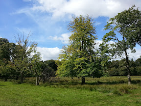
Looking towards Crowden Clough
I set off walking just after 3pm from the small car park a few hundred metres west of Barber Booth and followed the road through the small hamlet of Upper Booth, before picking up a footpath through the woods along the west bank of Crowden Brook.
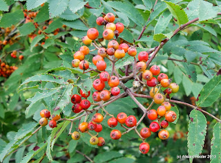
Rowan berries
Soon the path left the woodland, with its berry laden rowan trees, and I entered open country. There were excellent views up the heather sided clough towards the plateau above.  I passed a few small groups of other walkers, all descending, but it still felt quite quiet for a sunny day in August in the Peak District!
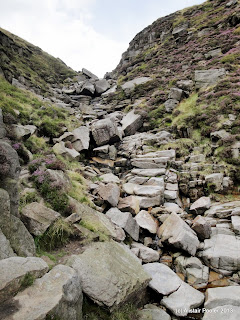
Crowden Clough
Higher up the clough the path ascends leftwards away from the brook but I had heard that a pleasant scramble could be had if I continued to follow the brook all the way up to the plateau edge path.  Therefore I followed the stream, sometimes next to it and sometimes scrambling over the boulders in the stream bed to reach a steeper section near a waterfall.  I concluded that this section definitely required a hands on approach and so I stowed my poles and scrambled on upwards to reach the plateau edge path above.  This route of ascent had been enjoyable, but I would definitely describe it as a scramble rather than just a rocky walk!

Some of the scrambly sections of Crowden Clough
Once on the plateau edge I turned left and followed the path past Crowden Tower and the interesting gritstone formations known as the Wool Packs to reach Pym Chair, said to be named after a 17th century non-conformist minister called John Pym.

The Wool Packs
Pym Chair
From here my route to the summit lay across the vast peaty plateau and I was glad I had chosen a day with good visibility!  The National Trust has been doing a lot of work up here in recent years to try to stop further peat loss due to erosion, and I passed a number of stone dams on the plateau.  It was also noticeable that grass appeared to be sprouting where there once was just bare peat - it will be interesting to return in a few years to see if this takes hold.
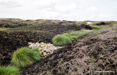
Peat erosion work
Peat erosion work
Soon I reached a cairn adorned with sticks and rope, which marks the position that the Nuttall's guidebook states is the summit.  However since that was published a survey was performed in 2009 to determine the exact location of Kinder Scout's summit (see here for links to the surveys).  Therefore I sat down on some nearby rocks to read the survey report before visiting the nearby grassy platform that marks the true summit of Kinder Scout (Marilyn, Nuttall).

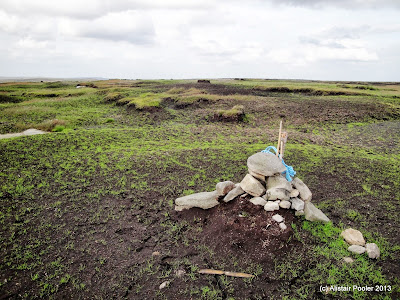
Cairn near summit of Kinder Scout
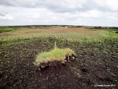
The tiny grassy summit of Kinder Scout
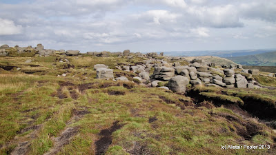
After having visited the summit, I headed westwards across the plateau to visit a nearby section of high ground, which according to the survey would become the summit if the current summit was subject to bad erosion.  There were good views across the peaty plateau in all directions.

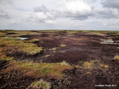
Kinder Scout summit plateau
Continuing across the plateau I headed SW to reach the trigpoint on Kinder Low, where there was a sign warning of ongoing helicopter operations.  I stopped here for a short break before continuing southwards along the Pennine Way.

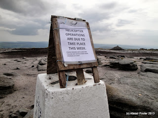
Sign on top of trig point
Kinder Low trigpoint
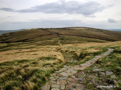
As I descended on the good path there were good views down into Edale and south towards Brown Knoll, where I had been walking one evening earlier this month.

Looking down Edale
Brown Knoll
I descended back into the valley by way of the Jacob's Ladder footpath, with good views towards The Cloughs and the bridge over the River Noe.

Descending Jacob's Ladder
Bridge over the River Noe
After a short break by the river I continued down the valley along the broad path, past the NT information barn and Upper Booth to reach the car shortly before 7:30pm after a most pleasant late afternoon hill walk :-)

See also my Social Hiking live map from the walk.

Monday 19 August 2013

Kinder South Evening Walk

Tuesday 13th August 2013 

An evening walk up Grindsbrook Clough to reach the Kinder Plateau 

Distance: 8.5km; Ascent: 410m; Dry, but breezy on the edge; Solo

Following Lynsey's walk up Grindsbrook Clough last week, I realised that it was well over 3 years since I had last walked up onto Kinder Scout that way so I decided to head that way this evening.  The Edale car park was pretty much deserted as I set off walking shortly after 7:30pm and headed up through the village, past the The Old Nags Head and out into the countryside.

Heading towards Grindsbrook Clough
The flagged path led across the fields below The Nab, followed by a short section of woodland before crossing the burn exiting Golden Clough, which marked the start of open country.

Bridge over Golden Clough burn
The track up Grindsbrook Clough was surrounded by lots of heather in full purple bloom, which is one of the things I like most about moorland walking at this time of year :-)

The track through the heather
Heather
As I ascended up the track the views back down the clough opened out and I began to see the Lose Hill - Mam Tor ridge on the other side of the Vale of Edale.  Around a kilometre after crossing Golden Clough the path deteriorated and dropped down to the brook.

Looking down Grindsbrook Clough
Grinds Brook
I ascended up the narrowing clough, sometimes on the left of the brook, sometimes on the right and sometimes scrambling over the boulders in the brook itself.  By the time I reached the fork near the top of the clough the light was beginning to fade, so I decided to ascend the ground to the right of the right-hand branch to gain the plateau-edge path.

Looking E along the southern edge of Kinder
Looking down into Grindsbrook Clough at dusk
Dusk sky over Kinder plateau
Unfortunately I was around 15 minutes too late to catch a glimpse of sunset from the plateau, but there were still impressive views and lovely dusk skies.  I headed east along the southern edge of the plateau, past the climbing crags of Upper Tor and Nether Tor to reach the top of Golden Clough - around now I donned my head torch as there was very little light left in the sky.

Looking towards Grindslow Knoll
The last light of the day over Grindslow Knoll
I began to descend from the plateau, traversing to the west of Ringing Roger to reach The Nab, from where a good path brought me back down to my route of ascent and thence Edale village.  I reached the car shortly after 10pm after another good evening walk :-)

See also my Social Hiking live map from the walk.

Sunday 18 August 2013

Delamere Forest

Saturday 3rd August 2013

A family walk in Delamere Forest

Distance: 5km; Ascent: negligible; Dry; with Lynsey, Isabel & Olivia

We hadn't been to Delamere Forest since last year so we decided to head over there for our first afternoon walk as a family of four after Olivia's arrival last month.  Arriving at around midday we found that the forest was clearly a popular place to be today judging from the large number of cars in the car park!

After a picnic lunch we set off walking shortly before 1pm, headed past the visitor centre and followed the red waymarked trail past the Go Ape course to reach the SE corner of Blakemere Moss.

Blakemere Moss
Blakemere Moss
Continuing to follow the red waymarkers, we followed forest tracks on the north side of the lake to reach the Sandstone Trail, which Lynsey & I had walked in its entirety over a weekend in early 2009.

Lynsey & Olivia
Clouds and trees
Delamere Forest
A little under a kilometre later we left the Sandstone Trail to return to the visitor centre for tea and cake after a pleasant afternoon walk :-)