Thursday 26 September 2013

Pen y Garn and a Huge Windfarm

Saturday 14th September 2013 

An evening ascent of Pen y Garn from the south by way of the Ystwyth Forest 

Distance: 8.5km; Ascent: 300m; Sunny; Solo

After my first walk of the day, I drove south from Nant y Moch Reservoir and set off walking from the corner of a minor road near Cwmystwyth at around 5pm.  A footpath led me into the Ystwyth Forest, where I picked up one of the many forest roads and began to gradually ascend.

On one of the forest roads in the Ystwyth Forest
Near the highest point of the forest road, a gap in the trees revealed a good view down into the Nant Rhuddnant gorge, and a short while further on the first wind turbine came into view.

View down to the steep sided Nant Rhuddnant valley
First sighting of a wind turbine
After a few hundred metres I left the main track at a junction where I forked right to begin to ascend up the northern slopes of Pen y Garn.  The wind turbines were now very close and they seemed out of place on this this otherwise remote high moorland.

Cefn Croes Windfarm
Looking north towards Pumlumon from Pen y Garn
I could make out the Pumlumon hills to the north, where I had been walking earlier in the day.  Soon I reached the top of Pen y Garn (Marilyn, Nuttall), where there was a trigpoint together with quite an elaborate windshelter cairn.  The trigpoint also had what looked to be its original OS plug, which I think is the first time I've seen one; pretty much all the other trigpoints I've visited either just had a hole in the top or it had been filled with concrete.

OS trigpoint on Pen y Garn
Elaborate windshelter on Pen y Garn
Pen y Garn trigpoint with the windfarm very close
On the actual summit of Pen y Garn
After a quick rest I visited the actual summit, which seemed to be somewhere near a gate a short distance away from the trigpoint.  There were good views from up here, although they were spoilt somewhat by the Cefn Croes windfarm, the closest turbine of which is only a few hundred metres away from the summit of Pen y Garn.

Lovely light on the descent from Pen y Garn
I descended southwards along the ridge to reach a vehicle track, which I followed down into Cwm Perfedd.  The light on the hills and clouds just before and just after sunset was excellent this evening!  So I spent a while trying to capture the best of it on my camera.  A track through the fields then brought me to the road a few metres away from my start point at around 7:30pm after a pleasant evening walk.

Sunset
Pink clouds over Cwm Perfedd
See also my Social Hiking live map from the walk.

Tuesday 24 September 2013

A Round of the Pumlumon Hills in Mid Wales

Saturday 14th September 2013 

A quiet six hour walk on the highest ground in Mid Wales 

Distance: 15.5km; Ascent: 710m; Sunshine and showers; Solo

I had plans for a two day backpack this weekend, possibly staying in one of the MBA bothies south of Pumlumon, but the dreadful weather forecast for Sunday put me off this idea somewhat!  However after studying the map I realised that with a few route modifications I could still just about manage to climb the six hills I had planned for the weekend in just one day: a day walk up the five Pumlumon hills followed by an evening walk up Pen y Garn, so that is what did!

After having driven over from Stockport this morning, my plans were almost thwarted by a road closure but luckily I was still above to reach my planned starting point on the eastern shores of Nant y Moch Reservoir.  I set off walking at around 10:30am and headed SW over rough ground alongside the Nant y Moch stream, before crossing a barbed wire fence at a dilapidated stile and beginning to ascend.

On the way up Y Garn from Nant-y-Moch Reservoir
Nant-y-Moch Reservoir
It was now quite warm so I stopped briefly to change into shorts before continuing my ascent up the grassy slopes of Y Garn with good views back down to Nant y Moch Reservoir and over to Pumlumon Fawr.  Eventually I reached the summit of Y Garn (Nuttall) where I decided to stop for an early lunch.

Summit of Y Garn with Pumlumon in the distance beyond
There were good views from here, especially of the rapidly approaching rain clouds!  After donning my waterproofs I descended eastwards along the undulating ridge with good views in all directions.  I could make out this evening's hill, Pen y Garn, to the south, together with a large windfarm nearby.

Heading east from Y Garn
The Cefn Croes windfarm from the north
Research Equipment from Aberystwyth University
I passed a series of pairs of small circular fences that were apparently something to do with a research project at Aberystwyth University before joining the south ridge of Pumlumon at the forest corner.  I ascended past the only two only walkers I saw today with good views, especially westwards back down to Nant y Moch Reservoir.

Pond on the S ridge of Pumlumon
Nant-y-Moch Resevoir from Pumlumon
At around 1pm I reached the many cairns and the trigpoint on the summit of Pumlumon Fawr (Marilyn, Nuttall) where I stopped for a second lunch break at my highest point for the day.

Large windshelter cairn on Pumlumon Fawr summit
There were excellent views from here, which was to be expected as it's the highest point south of Cadair Idris and north of the Brecon Beacons and Black Mountains.  It was a shame however that the view to the south was blighted by the large windfarm at Cefn Croes; and this was certainly not the only windfarm I could see!

On Pumlumon Fawr summit
Pumlumon Fawr summit trigpoint
I descended the steep ground to the NW before the short ascent to the cairn on the summit of Pumlumon Fach (Nuttall).

Summit of Pumlumon Fach
After retracing my steps for a few hundred metres, I took a traversing line above the cliffs overlooking Llyn Llygad Rheidol in the corrie below.

Llyn Llygad Rheidol
Pumlumon Fawr from the east
Once I was on the east ridge of Pumlumon Fawr it was a gentle walk eastwards to reach the grassy summit of Pen Pumlumon Llygad-bychan (Nuttall).

Summit of Pen Pumlumon Llygad-bychan
Boundary stone on Pen Pumlumon Llygad-bychan
A couple of boundary stones indicated the onwards route across the peaty moorland, with a slight drop followed by a bit of ascent to reach the two ancient cairns on the summit of Pen Pumlumon Arwystli (Nuttall).  According to hill-bagging.co.uk, the southerly cairn is the highest so this is the one I choose to stop at for a quick break as another heavy shower arrived.

Ancient cairns on the summit of Pen Pumlumon Arwystli
I retraced my steps for just over a kilometre before picking my way down the steep ground to reach the shores of Llyn Llygad Rheidol, which is another reservoir.

Llyn Llygad Rheidol
Llyn Llygad Rheidol
From the dam I picked up a reasonable vehicle track, which skirted around the north ridge of Pumlumon Fach before gradually descending down to the road a short distance away from my car.  It had been a pleasant walk in what seemed to be a little frequented area of hills.  Now it was time to drive southwards for half an hour to start my second walk of the day: the ascent of Pen y Garn.

See also my Social Hiking live map from the walk.

Monday 23 September 2013

The Edges Above Dovestone Reservoir

Monday 9th September 2013 

A circular walk along the gritstone edges overlooking Dovestone Reservoir 

Distance: 18km; Ascent: 500m; Mainly dry with heavy showers; with John J

I had taken the day off work today so that I could head out for a birthday hillwalk.  JJ was also free today so I arranged to meet him at Stockport station before heading to the car park below below Dovestone Reservoir's dam on a fine sunny morning

Alderman's Hill
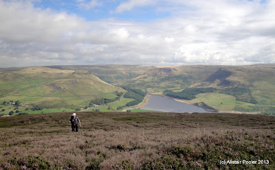
We set off walking just before half past nine and headed away from the reservoir along Bradbury Lane past a pretty row of terraced cottages before ascending to the woods by way of Intake Lane.  There were good views over the valley towards Alderman's Hill on the far side.

We took a direct line of ascent up towards Alphin Pike, which cannot be recommended as it involved wading through deep bracken and heather, crossing a barbed wire fence and ascending some unpleasantly steep ground.  However the ground did eventually begin to ease and soon we were walking through much more pleasant ankle deep heather!

JJ wading through the heather near the top of Alphin Pike
There were excellent views from the trigpoint on Alphin Pike, and it was clear that we were right on the western edge of the high ground with the flatter land of Manchester spreading out into the distant haze.

Summit of Alphin Pike
Manchester from Alphin Pike
We stopped by the wind shelter for a bite to eat whilst admiring the good views.  We also spent sometime studying our maps to see if we could have chosen a better route of ascent

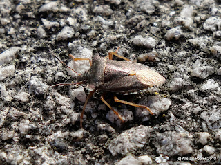
Bug on Alphin Pike trigpoint
After feeling suitably refreshed we set off along a pleasant moorland path, sometimes through the heather and sometimes across the bare peat, which was steaming in the heat of the sun.  This area was teeming with bugs, but luckily they didn't seem particularity interested in us!

Heading towards Wimberry Rocks
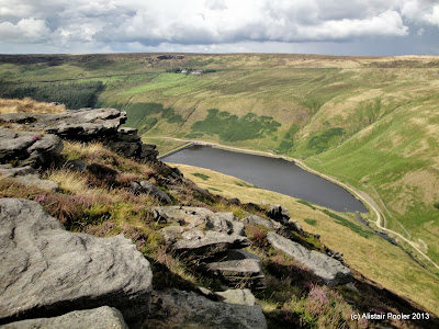
Soon we reached the impressive Wimberry Rocks, one of the many gritstone outcrops around the Chew Valley.  There were excellent views back down to Dovestone Reservoir from the top of this crag.

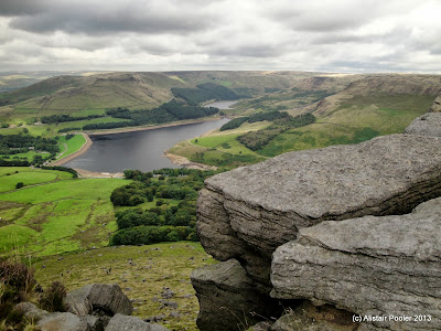
Dovestone Reservoir from Wimberry Rocks
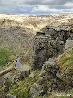
We continued along the edge past Wilderness, which this particular bit of the moor seems to be called according to the OS map!  I tried to identify the top of a scramble I'd done round here some years previously but it was a bit tricky to determine from above!

Chew Brook from Wilderness Rocks
The path petered out a bit as we approached Chew Reservoir, which dates from 1912 and was apparently the highest reservoir in England until 1971 when Cow Green Reservoir opened in the North Pennines (well that's what Wikipedia says anyway!)
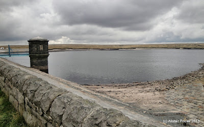
Chew Reservoir
We walked along the dam with good views of the surrounding moorland, with the Pennine Way out of sight only 3km away to the east.  By now a chilly breeze had developed, so we sought shelter near the north end of the dam for lunch.  There was some uncertainty about which moorland path we should take, and we initially opted for the one with the Peak and Northern Footpaths Society sign, i.e. the public right of way.  However after a short while we left this path to head WSW across the moor to pick up a reasonable path along the moorland edge.

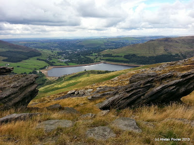
Looking down to Dovestone Reservoir from the east
Again there were excellent views down to Dovestone Reservoir from here, and in fact it had been our near constant companion since the start of the walk!  Continuing northwards along the edge we came to an area of crags, below which I spotted the remains of a building that I later discovered is called Bramley's Cot, although its original use is uncertain.  It was clearly a well constructed building, with holes cut into the crag itself for the roof, joists and beams.
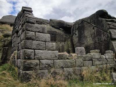
Bramley's Cot
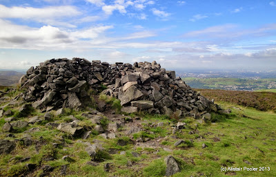
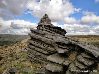
Continuing along the moorland edge we soon reached a large cairn on top of a gritstone outcrop known as Fox Stone, with a memorial plaque commemorating two climbers who were killed in the Dolomites in the 1970s.

Fox Stone
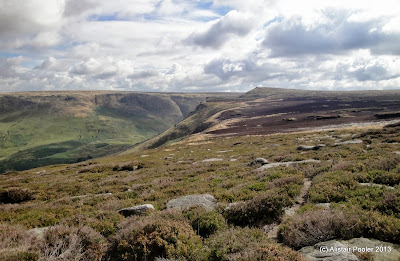
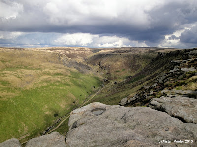
Soon we reached the impressive crags of Dove Stone Edge, where there were excellent views over the gritstone to Dovestone Reservoir below and Alderman's Hill beyond.

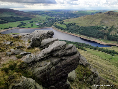
Dovestone Reservoir from Dovestone Edge
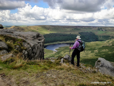
JJ at Dovestone Edge
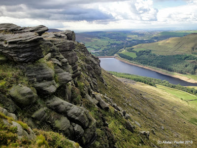
Dovestone Edge
Under darkening skies we walked east along the edge of Dove Stone Clough, before continuing northwards to a celtic looking memorial cross.  According to the engraved stone this marks the spot where James Platt, MP for Oldham, died due to a shooting accident in 1857.
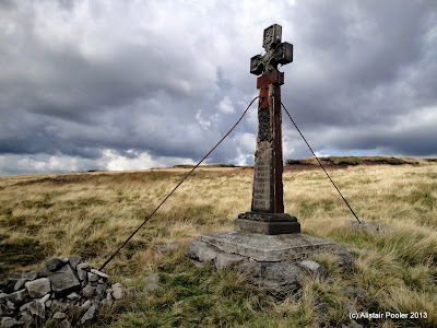
Memorial Cross
We stopped near here for a coffee and a bite to eat just before the arrival of a heavy shower, which resulted in me walking in waterproofs for the first time in months!  After coffee we wandered over to Ashway Rocks before continuing around the edge to the impressive crags of Ravenstones, from where there were good views down to Greenfield Reservoir along with the interesting looking Trinnacle.

Greenfield Brook from Ravenstones
Greenfield Reservoir from Ravenstones
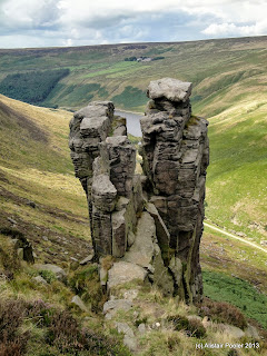
Ravenstones The Trinnacle at Ravenstones
Our original plan was to descend from near here down to Greenfield Brook below; however the ground looked unpleasantly steep so we continued along the path above Birchen Clough for a few hundred metres before dropping more gently down to the burn.  We picked our way downstream, sometimes on a faint path and sometimes just on the bare rocks just above the water.

Birchen Clough
After a few hundred metres we reached the vehicle track alongside Greenfield Brook, which we followed downsteam and then along the northern / western sides of Greenfield, Yeoman Hey and Dovestone Reservoirs to reach the carpark at around quarter to five after an excellent day's hillwalk; it's always nice to walk new ground for me, especially so close to home!
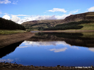
Dovestone Reservoir
See also my Social Hiking live map from the walk.