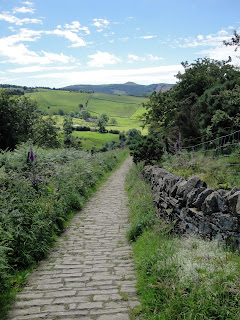
Distance: 4km; Ascent: 200m; with Lynsey & Isabel
Will the weather forecast promising temperatures of 27°C, we opted for a walk in the relative cool of the morning; although having said that it was still quite hot! We had decided on a 4km circuit of Tegg's Nose, which we hadn't been to since walking the Gritstone Trail back in early 2008.
We set off walking from the visitors' centre shortly before 11am, having been delayed by lots of traffic jams on route. There were good views across to Shutlingsloe as we descended down a stone track and then skirted the eastern side of the hill to reach Tegg's Nose Reservoir. From here, there was a section of steep ascent through the woods before we reached the more level path near the top of Tegg's Nose.
The views were good from up here as we walked past the some of the preserved old quarry equipment. The whole area at the top of the hill was covered with heather and bilberry with the occasional foxglove, so there were plenty of purple flowers around. Some people appeared to be bilberry picking, although I didn't actually see any ripe berries myself. We returned to the visitors' centre at around 12:30pm, where we enjoyed ice cream in the shade before heading home.
Sunday 26 June 2011
Sunday 12 June 2011
Sale Water Park
Distance: 5km; with Lynsey, Isabel, Mum & Dad
We decided to go for a more local walk today and settled on a visit to Sale Water Park. We set off walking soon after 10am and headed down to the edge of the lake to find it quite smelly and stagnant. Therefore we instead headed along the south bank of the River Mersey to Barfoot Bridge. Here we crossed to the northern bank and started to head back towards the cars. After a short distance, the rain started and gradually became heavier as we regretted not having brought waterproofs with us; Isabel on the other hand was quite dry as we did have the pushchair rain cover with us! We reached the cars at around 11:30am and headed home to dry out.
Labels:
Cheshire,
England,
Short Strolls
Location:
Sale Water Park, Trafford, UK
Saturday 11 June 2011
Two strolls in the Peak
Monsal Head Distance: 3km; Bugsworth Distance: 2km; with Lynsey, Isabel, Mum & Dad
I had recently heard that the tunnels on the Monsal Trail had been reopened for the first time since the railway line closed, which meant that it was no longer necessary to divert from the old railway line when trying to follow the Monsal Trail. Therefore, with my parents visiting, we headed off for a short 3km stroll around and underneath Monsal Head with Isabel in her rucksack carrier.
We set off from the carpark at Monsal Head at approx 11am under sunny skies and headed east along the road to Little Longstone, where we picked up the former route of the Monsal Trail along a footpath to eventually join up with the old railway line. From here we headed back west along the Monsal Trail to enter the Headstone Tunnel. The trail through the tunnel was quite busy, but reasonably well lit as we admired the engineering of the tunnel. Soon after leaving the tunnel we crossed the Monsal Viaduct with excellent views down to the Dale below; it must have been an impressive sight when travelling by train after having come through the tunnel. We headed back up the hill to reach Monsal Head just as it started to rain soon after midday so we headed into the tearoom for lunch.
On the way back home, we took a short detour to visit the Bugsworth Canal basin, near Whaley Bridge where some sort of festival was taking place that seemed to involve lots of people demonstrating the different sorts of engines that can be used in canal boats! We wandered along the towpath for around a kilometre from the carpark before returning to enjoy some ice cream.
Labels:
Derbyshire,
England,
Peak District,
Short Strolls
Location:
Monsal Head, Derbyshire, UK
Friday 10 June 2011
Wester Ross June 2011 - Index
Earlier this month, Ben and I spent five excellent days hill-walking in Wester Ross, three days based at Shenavall bothy and then a further two day walks near Kinlochewe. This page is an index on my blog posts on the trip, which I have updated to include maps of our routes, and there's also a link to my photos.
- Day 1 - Shenavall walk-in and An Teallach
- Day 2 - Beinn a'Chlaidheimh to Beinn Tarsuinn
- Day 3 - Beinn Dearg Mor & Beinn Dearg Bheag
- Day 4 - Slioch
- Day 5 - Meall a'Ghiuthais and the Mountain Trail
- Photos from the trip
Labels:
Corbetts,
Highland,
Highlands,
HuMPs,
Marilyns,
Munros,
North West Highlands,
Scotland,
Wester Ross,
Wester Ross June 2011
Tuesday 7 June 2011
Meall a'Ghiuthais and the Mountain Trail
Distance: 8.5km; Ascent: 900m; with Ben
After the long walks of the previous few days, we had to opt for something significantly shorter today as we both needed to be back in Inverness for late afternoon flights home. We set off walking from the car park on the shore of Loch Maree at 9:30am in full waterproofs as it was raining lightly. However, the rain soon stopped as we continued to ascend on the Beinn Eighe National Nature Reserve 'Mountain Trail', which was a well built path through the woodland and crags. Every so often, there was a cairn together with a sign indicating what to expect in the next section, e.g. steep path, geology, heather, etc.
There were good views over Slioch as we ascended and we reached the high point of the Mountain Trail at the 'Conservation Cairn', on the summit of Leathad Buidhe (Highland Five) shortly before 11am. Soon after we left the path and ascended up steep grass and scree slopes into the cloud to reach the northern summit of Meall a'Ghiuthais.
We headed SW along the ridge and reached the true summit of Meall a'Ghiuthais (Corbett) at about 12:15pm. It was very windy here and it was raining heavily so we didn't linger and descended back east to reach the Mountain Trail, which we followed back to the car, arriving at 2pm. We drove back to Inverness and caught our respective flights home. It had been a very good trip, if a bit tiring at times due to the long days, and we had climbed 7 Munros and 3 Corbetts.
Labels:
Corbetts,
Highland,
Highland Fives,
Highlands,
Marilyns,
North West Highlands,
Scotland,
Wester Ross,
Wester Ross June 2011
Location:
Highland, UK
Monday 6 June 2011
Slioch
Distance: 19km; Ascent:1330m; with Ben
After the last few days of walking in the Fisherfield whilst based at Shenavall, today we opted for a day walk accesible from the road for a change. As we had to drive round to Kinlochewe, we didn't actually set off walking until 10:15am. It was drizzling as we followed the path on the north side of the Kinlochewe River. After just over an hour we crossed the raging torrent of Abhainn an Fhasaigh by a bridge above one of its watefalls. After collecting water from a less ferocius side stream, we ascended up towards the bealach to the west of Meall Each. By now it had stopped raining and it was quite warm on the ascent.
Upon reaching the bealach, we stopped for lunch before continuing up the coire. The ascent up to the false summit was quite steep and we entered the cloud at around 850m. We continued up to the trig point and then on to the true summit of Slioch (Munro), which we reached shortly before 3pm. Whilst we were on the summit, the cloud briefly cleared for less than a minute to reveal a good view down to Loch Maree, before we were again surrounded by cloud, which was a shame as the views from here are said to be excellent.
Opting for a circuit of the hill, we descended the east ridge and soon dropped mostly out of the cloud. Looking along the ridge, it seemed as if it was a dividing line for the cloud as the north side was covered in cloud but everything to the south was free from cloud. We reached the summit of Sgurr an Tuill Bhain (Munro Top) at around 3:30pm. In descent we followed a path through the scree, which soon petered out, before picking a way down to the coire floor. We returned to the bealach to the west of Meall Each; by now the sun had come out and it was turning into a very warm afternoon.
We descended back down from the bealach via our ascent route, with good views over to Beinn Eighe. We got back to the car just after 7pm and headed to the Kinlochewe Hotel. After a long wait whilst they confirmed whether they had sufficient room in their bunkhouse for us, we were able to check in and enjoy an evening of food and beer in the pub.
Labels:
Highland,
Highlands,
Marilyns,
Munros,
North West Highlands,
Scotland,
Wester Ross,
Wester Ross June 2011
Location:
Highland, UK
Sunday 5 June 2011
Beinn Dearg Mor & Beinn Dearg Bheag
Distance: 22km; Ascent: 1530m; with Ben
After yesterday's even later finish, we again didn't set off walking from Shenavall until almost 9:30am, after having striked camp and left our overnight gear in the bothy for the day. We crossed the two rivers easily as there now hadn't been any rain since Friday evening. At Larachantivore we noticed that there was a small emergency shelter, which I imagine would be very useful if the rivers were in spate. We took a rightwards trending traverse up over heather to reach the foot of the east buttress of Beinn Dearg Mor. The scrambles guidebook contained a pleasant sounding grade 3 ** scramble up the east buttress, which we thought we would have a go at.
The first few outcrops were quite steep, so we turned the majority of them on the left either via heathery slopes or some easy scrambling. After a while we reached the foot of a much larger buttress, but we couldn't find the route described in the guidebook, so we again turned this on the left. Eventually we reached the ridge above this buttress and scrambled along the ridge. At one point, I found the exposure too great to the right so I opted to skirt round to the left whilst Ben continued along the ridge. We now reached a small col and concluded that the onwards route looked too exposed and wet so we instead headed up left up grass and scree to reach a level area on the ridge. By now it was 1:30pm so we stopped here for lunch with excellent views over to An Teallach. We hadn't actually ended up doing very much of the scramble and instead had a rough steep ascent over heather, boulders, grass and scree, but at least we were now almost at the top!
After a quick detour to the East Top of Beinn Dearg Mor (Corbett Top), we continued with good views down to the huge northern cliffs as we followed the rim of the coire and reached the airy summit of Beinn Dearg Mor (Corbett) at around 2:15pm. The views were again excellent as the cloud remained above the summits and it was dry, although not sunny. The descent down the NW ridge was unpleasantly steep, although there was a path down through the scree. At the bealach we left our bags and headed up the south ridge of Beinn Dearg Bheag. The lower part of the ridge was relatively gentle but the upper section involved picking a route through scree and small outcrops. We reached the spectacularly situated summit of Beinn Dearg Bheag (Corbett) soon after 3:30pm just as the sun was coming out. The views from here were some of the best of the trip, especially along the NNW ridge and out to sea.
We returned back down the south ridge and I spotted a well camouflaged ptarmigan amongst the scree and boulders. After reaching our bags we descended steeply down to Loch Toll an Lochain. We passed to the east of the loch and continued to descend down to the path alongside Loch na Sealga. We crossed the combined rivers at the point that others at the bothy had recommended. This was the deepest crossing of the trip, with the water just above my knees in places; however with my Dry Walkers over gaiters my feet remained dry, which was good!
We reached the bothy soon after 7pm, where we had a long break and our pasta dinner. At around 8:15 we set off walking again heading back to the car. The walk out seemed to go on forever and it started to rain at about 9:30pm. We finally reached the car at 10:45pm and headed back to where we had pitched on Thursday night. Another very long day!
Labels:
Backpacking,
Corbetts,
Highland,
Highlands,
Marilyns,
North West Highlands,
Scotland,
Wester Ross,
Wester Ross June 2011
Location:
Highland, UK
Saturday 4 June 2011
Beinn a'Chlaidheimh to Beinn Tarsuinn
Distance: 22km; ascent: 1770m; with Ben
After yesterday's late finish we didn't set off walking from Shenavall until after 9:30am. The river crossing wasn't too tricky as it was no more than knee deep; however according to the bothy book it had been impassable only a few days before. After crossing a boggy area, we headed steeply up the NW shoulder of Beinn a'Chlaidheimh. This was hard work and it seemed to go on forever; however there were excellent views over to Beinn Dearg Mor and An Teallach.
Eventually we reached the ridge line and followed a pleasant well defined ridge to the summit of Beinn a'Chlaidheimh (Corbett), which we reached at about 12:45pm. It was mainly overcast, but dry with the cloud above the summits; hence the views from here were excellent. After having lunch on the summit, we set off down the south ridge, dropping to a relatively low bealach at 650m where there was a tent pitched. To avoid the quartzite scree on the next peak we instead skirted to the right and up the coire.
We reached the summit of Sgurr Ban (Munro) at around 3pm and had a wee celebrationary dram by the summit cairn as this was my 200th Munro! After descending down to the next bealach we ascended steeply up a scree path to reach the summit of Mullach Coire Mhic Fhearchair (Munro), which we reached soon after 4pm. Again the views from here were excellent and extensive across the heart of the Fisherfield and Letterewe forests.
We descended steeply to a bealach before taking a traversing path around the NW side of Meall Garbh to reach another bealach. From here we ascended up to the top of our 4th Munro of the day reaching the summit of Beinn Tarsuinn (Munro) at approx 5:45pm. By now the sun had come out and it was quite warm. There were good views north down the valley towards An Teallach.
We had planned to continue over A Mhaighdean and Ruadh Stac Mor, but due to the time we decided to descend back to the bothy instead. The NW ridge of Beinn Tarsuinn was interesting with a prominent table part way along. We traversed the ridge and eventually found a way through the crags at its northern end. There was then a long walk back north alongside the river to Larachantivore followed by two river crossings to get back to Shenavall, where we arrived just before 11pm. A very long day!
N.B. Minor update made on 30/12/12 to reflect the change in status of Beinn a'Chlaidheimh, which is now a Corbett
Labels:
Backpacking,
Corbetts,
Highland,
Highlands,
Marilyns,
Munros,
North West Highlands,
Scotland,
Wester Ross,
Wester Ross June 2011
Location:
Highland, UK
Friday 3 June 2011
An Teallach
Distance: 19km; ascent: 1750m; with Ben
After a detour to Ullapool to buy some gas, Ben and I set off walking from Corrie Hallie at around 11:30am. It was hot and sunny as we ascended through the woods of Gleann Chaorachain with views across to An Teallach, which looked very impressive.
Soon after leaving the woods we turned right off the vehicle track onto a smaller, but good, path. This we followed, skirting the SE ridge of Sail Liath before dropping down into Strath na Sealga to Shenavall bothy. After dropping off our overnight kit and having a late lunch in the sunshine outside the bothy, we set off walking again soon after 2:30pm. We retraced our steps for 1.5km before starting to ascend up the SE ridge of Sail Liath. There were good views east towards the Beinn Dearg group of hills and the Fannichs.
We reached the summit of Sail Liath (Munro Top) at approx 4:30pm and admired the excellent views of the Corrag Bhuidhe ridge. By now it had got quite windy and the sky had mostly clouded over but it was still dry. After going over another Munro top, Stob Cadha Gobhlach, we sought out some easy scrambling on the initial ascent of Corrag Bhuidhe (Munro Top). We soon reached the 'bad step' and detoured to the left to climb a pleasant flake, which was tricky to start. We continued to traverse the ridge with much enjoyable scrambling, tricky in places, before we eventually reached Lord Berkeley's Seat (Munro Top), which was quite airy.
We continued along the ridge and made it to the top of our 1st Munro of the day, Sgurr Fiona, at around 6:30pm. As we were so far north and close to the longest day we didn't have to worry about daylight as there was at least another 4 hours of light left. By now we were in the cloud and the wind had picked up again. After leaving our bags in the bealach, we nipped up our second Munro of the day, reaching the summit of Bidein a'Ghlas Thuill at around 7:30pm.
We retraced our steps back to the bealach before traversing the north side of Sgurr Fiona to reach the bealach on its NW ridge. From here we descended steeply down scree and then grassy & heathery slopes. The cloud-base had clearly dropped as it took a while until we had descended out of the cloud. There was a short section of re-ascent to avoid crossing a deer fence and we then headed for the end of Loch na Sealga. We picked up the path back to Shenavall, where we arrived a little before 10:30pm. The bothy was busy so we pitched our tents for the night.
Labels:
Backpacking,
Highland,
Highlands,
HuMPs,
Marilyns,
Munros,
North West Highlands,
Scotland,
Wester Ross,
Wester Ross June 2011
Location:
Highland, UK
Thursday 2 June 2011
Wester Ross Plans June 2011
See route in new window with live progress
(Backup link without live progress)
This evening I will be catching a plane up to Inverness for five days of walking and Munro bagging with Ben. The map above shows various possible walks that we hope to do (although there are slightly more walks shown that we have time for!)
Our plans are to head to Shenavall bothy tomorrow morning and either base ourselves there or camp nearby for three days whilst we climb An Teallach, the Fisherfield Six and Beinn Dearg Mor & Beinn Dearg Beag. Then we plan to head to Kinlochewe and climb Slioch on Monday followed by a shorter day up either Beinn Ghobhlach or Am Faochagach depending upon the weather before returning to Inverness by mid afternoon.
Assuming that I get phone signal at some point during each day's walk, you should be able to follow my progress via the link above and I also plan to do some blogging whilst away.
Labels:
Corbetts,
Highland,
Highlands,
HuMPs,
Marilyns,
Munros,
North West Highlands,
Scotland,
Wester Ross,
Wester Ross June 2011
Location:
Wester Ross, Highland, UK
Subscribe to:
Posts (Atom)