Sunday 19 May 2013

A Short Wander up Moncreiffe Hill near Perth

Sunday 19th May 2013 

A short circular walk up a 223m high hill on the edge of Perth

Distance: 4.5km; Ascent: 180m; Misty but quite warm; Solo

After an excellent evening in Braemar last night catching up with many TGO Challengers, it was now unfortunately time for me to head home.  The weather wasn't overly inspiring this morning, with all the hills cloaked in mist down to quite low levels.  But I was still keen to get out for a walk to break up the journey south, if only for an hour or so.  Moncreiffe Hill near Perth seemed to fit the bill nicely and was only a short detour off route.

Therefore just before midday, I set off from the newish car park to the north of the hill and followed the good waymarked paths through the Woodland Trust's Moncreiffe Hill Wood.  There were a number of interesting sculptures and carvings alongside some of the paths.

Dragonfly sculpture in Moncreiffe Hill Wood
Slug sculpture in Moncreiffe Hill Wood
Misty Moncreiffe Hill Wood
The majority of my walk was along the white trail, with a brief detour up to the summit of Moncreiffe Hill (Marilyn), whose summit is marked by a cairn inside a hill-fort known as Moredun Top Fort.

Summit of Moncreiffe Hill in the Moredun Hill Fort
I headed west from this hill-fort to visit the second hill-fort, which was called Moncreiffe Hill Fort and it also contained a somewhat more modern addition in the form of an OS trig point!  It was slightly eerie being here in the mist as I could hear the traffic roaring by on the M90 a short distance below but I couldn't see more than twenty or thirty metres!

Trig point on Moncreiffe Hill Fort
I returned to the white trail and returned to the car past a number of other wooden carvings by the side of the path.  At around 1pm I reached the car and set off to continue my journey back home.

Pill millipede sculpture in Moncreiffe Hill Wood
Sculptures in Moncreiffe Hill Wood
See here for my Social Hiking map from the day's walk.

N.B. 04/07/13 - Post date updated to actual date of walk, i.e. 19/05/13 (from 02/06/13).  Links to social hiking, trig points and hill-bagging also added.

Saturday 18 May 2013

Beinn Liath Mhor Ghiubhais Li from Loch Glascarnoch

Saturday 18th May 2013

A misty morning walk up a Corbett just to the east of the main Fannich peaks

Distance: 8km; Ascent: 530m; Overcast and misty with occasional drizzle; Solo

The weather had changed overnight and this morning the sky was predominately grey, with occasional bursts of drizzle.  Heavier rain was forecast from mid-morning onwards so I decided that my planned Munro of Am Faochagach was out of the question due to the river crossing required at the start and end of the walk.  Therefore I instead settled on a lower hill on the other side of Loch Glascarnoch, which has a ridiculously long name: Beinn Liath Mhor Ghiubhais Li!

Looking WNW across the Dirrie More from the slopes of Meall Diamh
Just after 9am I set off walking from near the western end of Loch Glascarnoch and ascended up alongside the eastern edge of the forest, before continuing on up steeper rough ground to reach the summit of Meall Diamh (Highland Five).  By now it had started to drizzle so I donned my waterproofs and headed towards my main objective for the day, which was now covered with cloud.

Beinn Liath Mhor a'Ghiubhais Li from near Meall Diamh
After a further 250m of ascent I reached the misty summit of Beinn Liath Mhor Ghiubhais Li (Corbett, Marilyn), which is marked by a wind-shelter cairn around where the trig point used to stand, but a small bolt is all that now remains of the trig point.

Summit windshelter and OS bolt on Beinn Liath Mhor a'Ghiubhais Li
To make a circular walk I decided to descend the NW slopes of the hill, initially by compass bearing due to the low cloud, down to a flat boggier area about half-way down.  Descending beyond there I came to a deer fence, which initially appeared to have no obvious crossing point.  However as I approached it I noticed that for some reason there was actually a gap in the fence, which can't keep the deer out particularly well!

The gap in the fence heading down from Beinn Liath Mhor a'Ghiubhais Li
Soon I reached the forestry track that I had followed on last Sunday's walk, which I used to return to the road.  A short road walk then brought me back to the car in time for lunch.  It had been a good morning's walk and I now headed to Braemar to meet up with some of the TGO Challengers for the evening on my way home.

See here for my Social Hiking map from the day's walk.

N.B. 04/07/13 - Post date updated to actual date of walk, i.e. 18/05/13 (from 02/06/13).  Links to social hiking, trig points and hill-bagging also added.

Friday 17 May 2013

Three of the Glen Strathfarrar Munros

Friday 17th May 2013  

A excellent round of three Munros to the east of Loch Monar in the NW Highlands 

Distance: 16km; Ascent: 1370m; Dry with occasional sunshine and light winds; Solo

Back in 2009, Lynsey and I had an excellent high-level route planned for that year's TGO Challenge, of which the first three days would have been bagging all the Munros and Corbetts to the north of Loch Monar and Glen Strathfarrar.  Alas the weather didn't play ball, which meant we instead had a wild and stormy two days of mainly walking past the hills, including probably the stormiest night I've ever spent in a tent!  However by the third day the weather had calmed down and we were able to climb the westernmost of the Glen Strathfarrar Munros.  Unfortunately though the storm had brought significant amounts of fresh snow, which meant that we had to descend after the first peak and walk down the glen to Struy.

Therefore my three remaining Munros to the north of Glen Strathfarrar were high on my list of planned walks for this week and today the weather forecast was pretty good.  Access to these hills for a day walk is complicated by the fact that the tarmac road up Glen Strathfarrar is private and the gate at the foot of the glen is only opened for vehicle access between certain times of the day on certain days of the week.  As today was one of the days the gate would be opened, I decided to head up the glen for a round of these three peaks.  Therefore at a little after 10am I set off walking alongside the Allt Coire Mhuillidh :-)

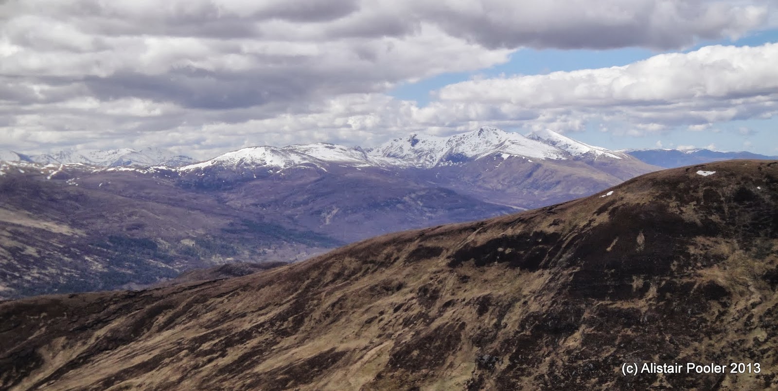
Sgurr a' Choire Ghlais & Carn nan Gobhar from Coire Mhuillidh
Sgurr na Rhuaidhe from Coire Mhuillidh
Initially I followed a vehicle track for around a kilometre to reach a weir, beyond which I followed a rougher path further up into the coire.  After crossing a side stream I began to ascend up the SW slopes of my first Munro of the day, Sgurr na Ruaidhe, initially on a faint but obvious path.

Looking SW from Sgurr na Ruaidhe towards the Mullardoch peaks
There were good views as I ascended, especially south-west towards the peaks to the north of Loch Mullardoch, where I had been walking back in November last year.

The peaks north of Loch Mullardoch
At around 1pm I reached the summit of Sgurr na Ruaidhe (Munro, Marilyn), where I stopped for lunch next to the cairn with truly fantastic views :-)

Summit of Sgurr na Ruaidhe
There were excellent views along the lower ridge to the east, along with the much snowier hills to the west towards Loch Monar.

Looking east from Sgurr na Ruaidhe
Looking towards the Loch Monar hills Sgurr na Ruaidhe
Sgurr a' Choire Ghlais & Carn nan Gobhar from Sgurr na Ruaidhe
I descended the NW ridge of Sgurr na Ruaidhe down to the bealach whilst enjoying the excellent views :-)  An ascent of just over a couple of hundred metres brought me to the summit of my second Munro of the day: Carn nan Gobhar (Munro, HuMP).

Looking NNW from Carn nan Gobhar towards Fisherfield
There were excellent views SW towards my next peak, which was significantly more snowy than the first two of the day.  In the distance towards the NW I could make out some of the Torridon and Fisherfield hills, which brought back memories of many happy days climbing those hills over the last few years :-)

Sgurr a' Choire Ghlais from Carn nan Gobhar
On the summit of Carn nan Gobhar
After a bite to eat by the summit cairn, I set off towards the imposing snowy peak of Sgurr a'Choire Ghlais, the highest of the Strathfarrar Four.  From a distance it appeared that I may need my ice axe, which I had carried today along with my crampons due to the unseasonable snow cover on the hills, however other than the very highest slopes I was able to avoid the snow as I ascended.

At around quarter past three I reached the snowy summit of Sgurr a'Choire Ghlais (Munro, Marilyn), which was marked by two cairns and a trig point.  There were excellent views west towards Sgurr Fhuar-thuill, which was the only one of these hills that Lynsey & I had managed to climb four years ago on our last TGO Challenge crossing together.

Sgurr Fhuar-thuill & Creag Ghorm a' Bhealaich from Sgurr a' Choire Ghlais
I visited both summit cairns along with the trig point, but didn't venture too close to the eastern edge of the small summit plateau as from below it appeared that it might actually be corniced!  The sky was quite moody towards the east, but no rain appeared :-)

Summit trigpoint on Sgurr a' Choire Ghlais
Snowy cairn on Sgurr a' Choire Ghlais
The south ridge of Sgurr a' Choire Ghlais
I descended the south ridge of Sgurr a'Choire Ghlais, mainly staying off the quite soft snow, until I was almost at the bealach to the north of Meall a'Gheur-fheadain.  I then picked my way down initially quite steep slopes to reach the floor of Coire Mhuillidh, with good views back to my first two hills of the day.

Looking back to Carn nan Gobhar and Sgurr na Ruaidhe
I waded the foot or so deep Allt Coire Mhuillidh to re-join my outward route, which I followed back down to the car in the glen.  I reached the car at around quarter to six after an absolutely fantastic day out walking in the hills :-)  I then headed back to the Aultguish Inn, where I had a pub dinner washed down with An Teallach ale to celebrate now having less than fifty Munros left to climb!

See here for my Social Hiking map from the day's walk.

N.B. 30/06/13 - Post date updated to actual date of walk, i.e. 17/05/13 (from 30/05/13).  Links to social hiking and hill-bagging also added.

Thursday 16 May 2013

Bynack More and Creag Mhor

Thursday 16th May 2013

A fantastic day's hill walking up a Munro and a Corbett in the Cairngorms

Distance: 25.5km; Ascent: 1260m; Mainly dry but showery at times; Solo

There were many TGO Challengers staying in Aviemore last night, of which a fair few of them seemed to be at the bunkhouse so I had quite a sociable breakfast this morning :-)  I had decided to delay my return to the northern highlands until this evening as I didn't fancy getting stuck in the roadworks over the Kessock Bridge during the morning rush hour!  Therefore instead I decided to head for Bynack More in the Cairngorms.

Trees in the Pass of Ryvoan
At around 10am I set off walking from the end of the road by Glenmore Lodge along a broad forest track.  It was warm and sunny as I walked through the pleasant woodland to reach An Lochan Uaine and the Pass of Ryvoan.

An Lochan Uaine
Heading east away from the Pass of Ryvoan
The good track continued through the Pass of Ryvoan, past the turning for the bothy to reach Strath Nethy, where I stopped for a quick break next to the river.  There were good views from here up the valley towards The Saddle.

Bridge over the River Nethy
Now the ascent began in earnest, although it was made easier by the well maintained footpath that ascends up onto the northern slopes of Bynack More.  There were good views back down to the NW towards the Corbett of Meall a'Bhuachaille.

Looking NW towards Meall a'Bhuachaille
At around the 750m contour the slope angle eased and soon afterwards I reached a fork in the track.  I headed south towards Bynack More, whilst the left-hand fork was the route onwards into the Lairig an Laoigh.

Looking S towards the upper slopes of Bynack More
The Bynack More path was badly eroded in places, although some sections of it had clearly had work done to them recently.  There was a large patch of soft-ish snow to cross at the point the northern slopes steepened into a more well-defined ridge, before I continued on upwards over the rocks to reach the summit area where there were excellent views.

Summit area of Bynack More
Beinn Mheadhoin, Ben Macdui & Cairn Gorm from Bynack More
Despite the bitterly cold wind, there were a least ten other walkers on the summit slopes - in fact it was the first time I had seen anyone else whilst out walking on the hills since Saturday!  I found a spot to shelter from the bitter wind for a quick lunch break before visiting the summit cairn of Bynack More (Munro, Marilyn) together with the nearby rocks which looked to be just as high!

Summit cairn on Bynack More
On the summit of Bynack More
Despite the mainly overcast skies there were excellent views from the summit, especially south-west towards the horseshoe of peaks around the Loch Avon basin, i.e. Beinn Mheadhoin, Ben Macdui and Cairn Gorm.  There was also a good view of the Lairig an Laoigh, guarded either either side by the steep slopes of Beinn a'Chaorainn and Beinn Mheadhoin.

Looking SSW from Bynack More towards Beinn a'Chaorainn and Beinn Mheadhoin
I had originally planned to descend by my route of ascent but as it wasn't yet 2pm, and I wasn't in a particular hurry to get back to the car, I decided to tag on the ascent of the nearby Corbett of Creag Mhor onto my walk.  Therefore I headed down the south ridge of Bynack More to reach the impressive Barns of Bynack.

Some of the Barns of Bynack
A Barn of Bynack
I then picked my way down the steep ground, roughly in a SSE direction to reach the small lochan in the Lairig an Laoigh.

Looking down to Lochan a'Bhainne in the Lairig an Laoigh
From here it was only a relatively short ascent of around 170m to reach the top of the hill, and the slopes were mostly significantly less steep than what I had just descended!  There were good views back to Bynack More as I ascended, and I soon reached the summit rocks of Creag Mhor (Corbett, Marilyn) just before 3pm.

Bynack More from Creag Mhor
Summit rocks of Creag Mhor
There were good views from the summit, but again I didn't linger long due to the cold wind blowing!  I descended roughly to the NW to reach the Lairig an Laoigh path just before it started to ascend.  The path here was significantly more eroded than the section I had walked this morning ascending out of Strath Nethy.

As I ascended up the path a large group of teenagers with large backpacking sacks came the other way - I assumed that they were heading for an overnight camp somewhere further along the Lairig an Laoigh.  Eventually I reached the large plateau on the north ridge of Bynack More, where I rejoined my outward route.

Looking SW through the Pass of Ryvoan
The descent down into Strath Nethy was relatively quick and I was soon walking back through the Pass of Ryvoan into the woods.  Around a kilometre away from Glenmore Lodge I met a TGO Challenger heading for Ryvoan bothy so we stopped to chat for a while.  I reached the car at around half-past six after an excellent day's walking in the hills.  I then headed back north to the Aultguish Inn's bunkhouse for the next couple of nights.

See here for my Social Hiking map from the day's walk.

N.B. 28/06/13 - Post date updated to actual date of walk, i.e. 16/05/13 (from 24/05/13).  Links to social hiking and hill-bagging also added.
 

Wednesday 15 May 2013

The Carn Deargs of Glen Roy

Wednesday 15th May 2013 

Two Corbetts on my way back to the Glen Roy road from Luib-chonnal bothy 

Distance: 14km; Ascent: 730m; Rain & hail showers and quite windy up high; Solo

Despite last night's merriment I was still awake at 6:30am this morning!  However as I had a relatively short day's hill-walking planned I decided to have a bit of a leisurely morning at the bothy before setting off into the hills.  Andy left by 8am heading for Creag Meagaidh, whilst Andrew, Phil and Alan left at 8:30am heading for Melgarve on their way to Laggan.  The river outside the bothy didn't appear to be particularly tricky to cross this year, unlike when it was in spate when Lynsey was here last year.

Luib-chonnal bothy
Phil, Alan & Andrew crossing the Allt Chonnal
After spending a while chatting to Richard back in the bothy, I decided that I really should think about climbing some hills today!  Therefore I set off walking from the bothy at around 9:45am and followed a vague path on the south side of the Allt Chonnal, with good views back to the bothy with Creag Meagaidh beyond.

Creag Meagaidh and White Falls
By the time I reached the bridge over the burn, around a kilometre upstream from the bothy, it was raining heavily.  So waterproofs were donned before I continued along the north bank of the burn.

Bridge over the Allt Chonnal
The rain turned out to be a relatively short-lived heavy shower, and soon I was bathed in warm sunshine :-)  This was how the weather would stay for much of the rest of the day, with heavy rain and hail showers interspersed with drier intervals.

Looking up the Allt Dubh to Carn Dearg (N)
As I continued along the north bank of the Allt Dubh, there were good views up to my two peaks for the day, which unimaginatively were both called Carn Dearg!  Once I had reached the 550m contour the bealach to the west appeared to be full of peat hags.  Therefore I opted to take a diagonal line NW up the steep slopes to eventually arrive at the summit of the northern Carn Dearg (Corbett, Marilyn) soon after half-past midday.

Summit cairn on Carn Dearg (N)
There were good views from up here, especially across to the Loch Lochy Munros and Ben Tee.  However it was very windy and quite cold so after a quick lunch I descended southwards towards the bealach, with good views across to the southern Carn Dearg.

Looking towards Carn Dearg (S) from Carn Dearg (N)
The slopes on the southern side of the bealach were also quite steep, but after 200m further ascent I finally reached the summit cairn of the southern Carn Dearg (Corbett, Marilyn) at around quarter-past two.

On the summit of Carn Dearg (S)
Again the views from the summit were excellent and I could see most of the way down Glen Roy from here.  However despite the sunshine it was still quite cold due to the bitter wind, so I didn't longer long.

Looking down Glen Roy from Carn Dearg (S)
To descend I initially headed SW for around half a kilometre, after which I picked up a faint path marked with stakes.  This initially headed in the right direction, but after a few hundred metres it appeared to start heading NW, which was definitely the wrong direction for me!  Therefore I headed directly down the steep slopes to reach the vehicle track in upper Glen Roy.

The River Turret in Glen Roy
I crossed the bridge over the River Turret and reached the car shortly afterwards at 4pm.  It had been a good short backpack, even though I hadn't even been away from the car for 24 hours!  Now I headed to Aviemore for the evening where I met up with Martin, Philip and John for a curry :-)

See here for my Social Hiking map from the day's walk.

N.B. 21/06/13 - Post date updated to actual date of walk, i.e. 15/05/13 (from 23/05/13).  Links to social hiking and hill-bagging also added.