Sunday 29 January 2012

Offa's Dyke Path - Day 2: Bodfari to Llandegla

Distance: 28km; Ascent: 1280m; Solo

After yesterday's walk, my longest for a couple of months, I slept well in my comfortable B&B.  I woke just before 7am, and after a huge breakfast I set off walking shortly after 8am in the early light of day.

On the ascent out of Bodfari
After a wander across a couple of fields, I reached a minor road that I briefly followed before picking up a bridleway that skirted round the SW slopes of Moel y Parc to reach a track junction up on the ridge.  There was a cold wind up here and it was significantly cooler than yesterday, with the sky completely overcast, although at least it was dry!

View north from Penycloddiau
After a relatively short easy ascent following grassy paths through the bracken and heather, I reached the summit of my first hill for the day at 9:30am: Penycloddiau (Marilyn), which was also an Iron Age hill-fort.  The views from here were good, including across to most of the Snowdonia ranges and the Berwyns.

On summit of Penycloddiau
I continued onwards through the heather before dropping down to the edge of some woodland and thus to a car park and minor road.  Here I entered the Moel Famau country park, which must cover a reasonable area as I was still some way away from Moel Famau itself!  After around a kilometre, I reached a path junction where I deviated from the Offa's Dyke Path to visit the summit of Moel Arthur (HuMP), which was another hill-fort.  As I descended the steep SE flank of the hill to a minor road running through another pass, it was clear to see why this particular hill had been chosen to site a hill-fort on.

Moel Arthur from the south
The climb out of the other side of the pass was quite steep for the first few hundred metres, but it did afford good views back to Moel Arthur.  Soon the ground levelled out and I followed the undulating Offa's Dyke Path through the hills to reach the final slightly snowy ascent up onto Moel Famau (Marilyn, Dewey), whose summit I reached just after midday.  The hill is crowned by the remains of the Jubilee Tower, which was built to celebrate the jubilee of George III in 1810 and today provided welcome shelter from the cold wind whilst I had my lunch!  After lunch I took a wander over to the trig point and also to the unmarked true summit near the tower.

Summit of Moel Famau
The path down Moel Famau was the widest so far, and it was easy to see why as there were literally hoards of people on their way up or down the hill from the conveniently sited car park.  Given it was so popular on such a cold day, I suspect it's somewhere to avoid on warm sunny weekends if you're a lover of solitude!

Summit of Foel Fenlli
After leaving the car park and the masses behind, I ascended up narrow paths through the heather to visit the summit of Foel Fenlli (Marilyn, Dewey) where it began to snow very lightly.  The views were again good, but most of the Snowdonia hills were now completely obscured by the cloud and I suspected that it was snowing somewhat heavier over them than here.

I dropped down to the south, before following field paths and a gorse banked track around Moel Eithinen to the A494 at Clwyd Gate.  After a brief walk along the busy road, the ascent began again in earnest!  The direct route to my final hill for the day, Moel Gyw, didn't look too pleasant given it was steep pathless bracken and heather!  Instead I opted to follow the Offa's Dyke Path around to the bwlch to the south of the hill, before following a good path up to the summit of Moel Gyw (Marilyn), which was marked by a trig point and a small nearby slightly higher cairn; I visited them both.

Summit of Moel Gyw
By now it was 3pm at it was looking somewhat unlikely that I would catch the last bus from Llandegla at 4pm given that it was over 8km away!  I continued to follow the Offa's Dyke Path as it contoured around Moel Llanfair and Moel y Plâs before reaching a radio mast and then a minor road.  In an attempt to get to Llandegla quicker, I opted to stick on the road for the last 3km rather than following the more circuitous field paths.

I rang for a taxi to meet me in Llandegla when I was about 2km away and had fun trying to arrange where to meet as their system couldn't cope that I didn't know the postcode for the village!  Eventually we settled on the post office as it was somewhere on my map and they thought that they should be able to find it!

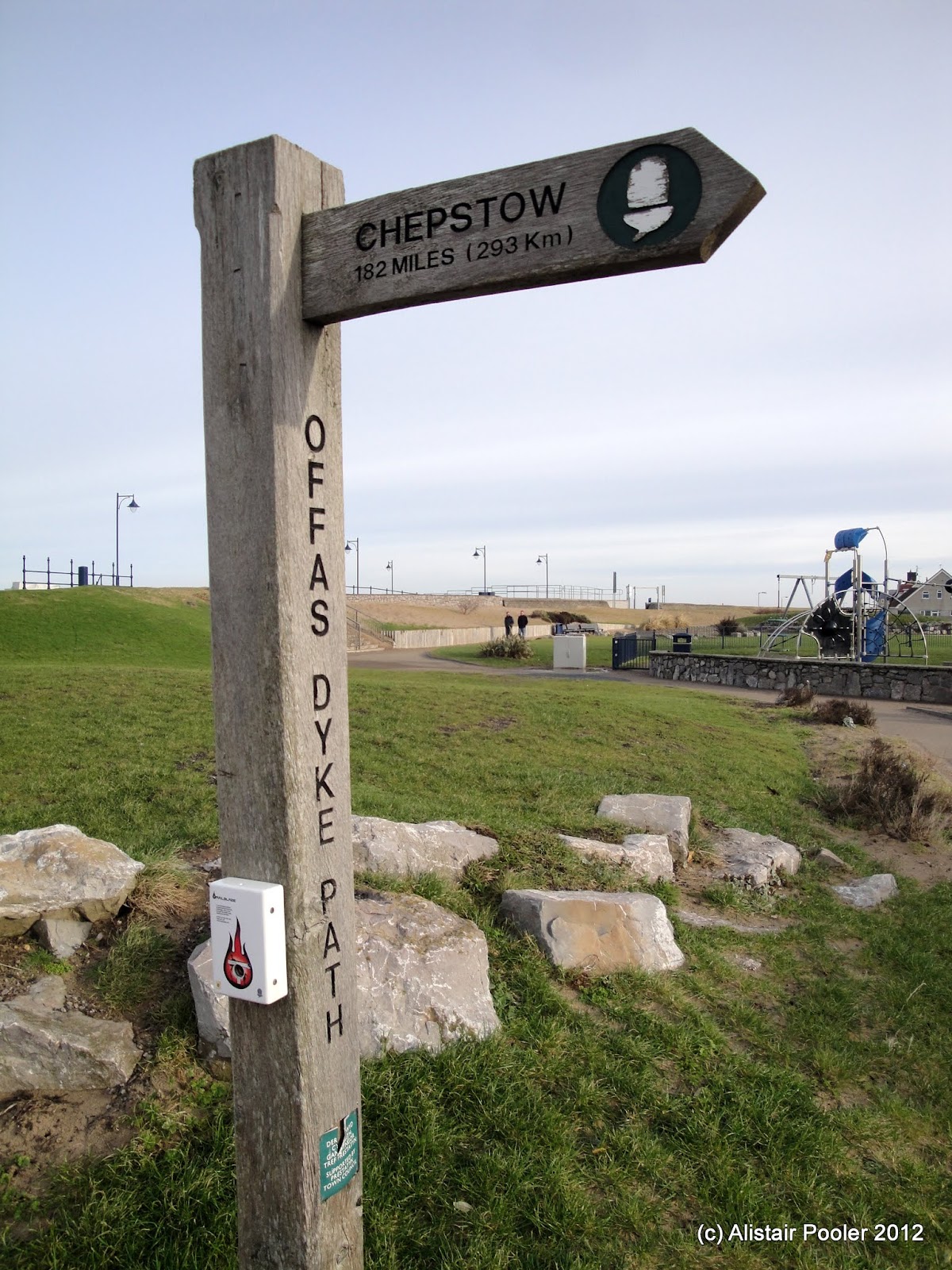
Offa's Dyke Path signpost in Llandegla
I reached Llandegla just after 5pm, where there was a handy sign informing me that I had walked 29 miles from Prestatyn this weekend and it was only another 148 to go to Chepstow; however they would have to wait for other weekends!  My taxi arrived after a few minutes and the Polish driver was excited to learn that I had been snowed on this afternoon as he said he missed the snow!  I made the delayed six o'clock train from Wrexham, only to just miss my connection in Chester and thus I didn't get home until 8:30pm.  It had been a good couple of day's walking and I was glad that I had decided on the Offa's Dyke Path; I will have to return again soon to continue it.

Written on 01/02/12

Saturday 28 January 2012

Offa's Dyke Path - Day 1: Prestatyn to Bodfari

Distance: 21km; Ascent 680m; Solo

My most recent backpacking trip was now over three months ago and I was keen to get out backpacking again.  I decided to have a crack at walking another long distance path over several weekend sections, as I did with the Pennine Way between 2008 and 2010.  After studying various maps and public transport details, it seemed like the most likely contenders were the Dales Way and the Offa's Dyke Path with the latter slightly more preferable as it spends more time in the hills.  I had also been thinking of returning to the Clwydian Range of hills since I made one brief foray there to climb Moel Famau a few years ago, and so my decision was made - the Offa's Dyke Path it is!

On Prestatyn Beach
This morning I caught a succession of three trains from Stockport to Prestatyn, changing in Crewe, where I managed to grab a quick coffee and sausage sandwich between trains, and Chester.  I wandered down to the beach from Prestatyn station to dip my boots in the sea, before having a look at the shiny sculpture that marks the start of the Offa's Dyke Path.

Sculpture marking the start of the Offa's Dyke Path and sign showing indicating 182 miles to Chepstow
I left Prestatyn beach at 10:45 and walked south, through the station and ascended up the high street to reach the Hillside Gardens on the south eastern edge of town, where there was a large sculpture of a Roman helmet.  Slightly further up the hill, there was a sort of balcony from where there was a good view out over the town and the nearby coastline.

View from Hillside Gardens, Prestatyn
I continued to ascend, with good views west across the hazy valley to the snow covered peaks of the Carneddau.  Eventually the path levelled out and I headed south across the gorse covered hillside, high above the houses below.  After crossing the A5151, I passed the remains of a mill and began to ascend up the hillside of Marian Ffirth, on the top of which I stopped for lunch in the sunshine.

View back NW from Marian Ffrith
After lunch, I descended through limestone country to reach a minor road followed by field paths to reach the woodland on the slopes of Mynydd y Cwm.  Here, I took a minor detour from the Offa's Dyke Path to follow tracks and a path through the woodland to reach the summit of Mynydd y Cwm (Marilyn).

Mynydd y Cwm woodland
The summit area was deep in the woods so there were no significant views to speak of.  I returned to the minor road to the east to pick up the Offa's Dyke Path again, before following it SW as it descended through the gorse to reach Rhuallt

Track through gorse on route to Rhuallt
I stopped for a quick break in the sunshine on a pleasant bench in Rhuallt, before crossing the A55 and ascending up through more gorse to reach the summit of Moel Maenefa (HuMP), which seemed to be missing its trig point but the views were excellent.

Moel Maenefa
Soon the path joined a minor road, which I followed for a kilometre before cutting a corner by heading over Cefn Du and then descending past Sodom, with excellent views west to the sun setting behind a bank of cloud over Snowdonia.

Sunset on the way to Bodfari
I reached Bodfari just as it was getting dark at 5pm and found my comfortable B&B for the night, where I discovered that I was their first ever guest in January (previously their earliest had been in February).  I headed out to the Downing Arms for an excellent dinner of whitebait followed by steak, before returning to my B&B and getting an early night - I think I was asleep by 9:30pm!

Written on 31/01/12

Wednesday 18 January 2012

Two Berwyn Walks: A Waterfall and Two Hills

Post Gwyn: Distance: 12km; Ascent: 370m; Solo
Foel Cwm Sian Llŵyd: Distance: 2.5km; Ascent: 180m; Solo

I had booked today off work a couple of weeks ago with the intention of going hill walking somewhere for the day.  Typically, however today turned out to be the day when the nice weather of the last few days broke and it was cloudy and drizzly in Stockport this morning.  The forecast suggested that it might improve in the afternoon, so after dropping Isabel at nursery I headed for the Berwyn hills with the aim of climbing my remaining two 2000ft peaks in the area.

The Afon Disgynfa valley above the waterfall
The weather seemed to improve as I headed south from Chester, with the sun even coming out at times.  However this was not to last as it was drizzly with low cloud when I arrived at the car park below Pistyll Rhaeadr.  I set off walking in full waterproofs at around 11:30am and after a brief look at the waterfall I ascended up the good path to the top of the falls, from where there was a good airy view out of the valley.  I then continued up the wide, and in places boggy, Afon Disgynfa valley, above the waterfall, to reach a ruined sheepfold at the foot of Cwm Rhiwiau where I stopped for lunch.

Cairn near the summit of Post Gwyn
After lunch, I continued to follow the stream up the valley for around a kilometre to the foot of Cwm yr Eithin.  From here I followed some rough tracks uphill to the south of the stream, which soon petered out in the heather.  The Berwyn heather is famous for being energy sapping and hard to walk through, but I found it no more tricky than similar heather covered hill sides in Scotland.  Anyway after around 150m of ascent from the stream, I reached the summit of Post Gwyn (Nuttall) and ensured I visited the true summit marked by a small flat cairn in addition to the much larger more obvious cairn nearby.

On the summit of Post Gwyn
The views from the summit were typical of those from many British hills, i.e. a good view of the inside of a cloud!  However as I descended down the broad SE ridge, I dropped out of the cloud and soon there were excellent views.

Small tarn on SE ridge of Post Gwyn
After passing an area of forest on the left, I reached a small tarn which was still partially frozen from the recent cold spell.  Soon I began to drop off the ridge to the north into Cwm yr Ast.

Moel Sych and neighbouring hills from Cwm yr Ast
At the bottom of Cwm yr Ast, I reached the top of Craig yr Mŵn (crag of the ore), from where there were excellent views up and down the Rhaeadr valley from an airy promontory above the cliffs.

View of head of the valley from Craig y Mŵn
View down Rhaeadr valley from Craig y Mŵn
I descended by a devious path, which followed a slanting grassy terrace between two sections of the cliff to reach a broader track and then the remains of an old leat, which I followed back to Pistyll Rhaeadr.  This waterfall is very impressive and is amongst the highest in Wales.

Pistyll Rhaeadr
I returned to the car at around 3pm and set off on the short drive to reach the start of my second walk of the day at the summit of the Milltir Gerrig pass.  I set off walking through yet more Berwyn heather at around 3:40pm, after having made certain that I had my headtorch with me and it worked!  (I was uncertain quite how much usable daylight was left and how long this short walk would take due to the terrain).

Summit of Foel Cwm Sian Llŵyd
After 35 minutes of uphill heather bashing, I reached the summit of Foel Cwm Sian Llŵyd (Nuttall).  The views from the trig point were excellent and the sun was just setting; I was very glad that I had decided to press ahead with my ascent!

Sunset from summit of Foel Cwm Sian Llŵyd
After having admired the views and the sunset, I headed N along the ridge to the remains of a building before taking a direct line back through the heather to the car, where I arrived at 4:45pm still with sufficient light to see without a headtorch.  It had been a good day of peak bagging, with the weather generally being better than forecast.

Sunday 15 January 2012

A Wander Around Austwick

Sunday 15th January

Distance: 3km; Ascent: negligible; Sunny; with Isabel, John, Steph, Sierra and Jack 

Lynsey was away backpacking in the Yorkshire Dales this weekend.  I decided to head up to the Dales myself today for a bit of a walk with Isabel, so I arranged to meet up with some friends in Austwick this morning for an ATP walk.

View of some inviting hills!
We set off walking at around midday along a pleasant bridleway in the winter sunshine.  Soon we crossed Austwick Beck by way of Flascoe Bridge, which was slightly tricky due to it's narrow width relative to the pushchairs!

Flascoe Bridge
Austwick Beck
There were good views of the hills to the SE of Ingleborough as we headed along Wood Lane, past signposts for the newest section of the Pennine Bridleway, to find a spot by the edge of the track to stop for lunch.

Signpost for the new Pennine Bridleway
After reaching the end of the Wood Lane bridleway we returned to Austwick by way of the minor road, reaching the cars at around 2:30pm.  It had been a good short walk in the sunshine and I now headed to Horton to meet Lynsey after her two days of backpacking.

Written up in January 2013 from photos and memories

Tuesday 10 January 2012

A Morning Stroll at Lyme Park and plans for my next backpack

Distance: 3km; with Isabel

I had the day off with Isabel today, and it was forecast to be dry so a morning walk somewhere was in order.  Both MWIS and the Met Office forecast there to be hill fog in the Peak District, so I opted to leave my planned walk around the Roaches until another day.  Instead we headed to Lyme Park, which I hadn't been to for many months.

Knightslow Wood, Lyme Park
Our chosen walk for the morning was "The Moorland Way", a 2 mile stroll described in one of the National Trust's Lyme Park walk leaflets, and the suggested time was 1.5 to 2 hours, which seemed awfully long for the distance!  I set off walking at around quarter past ten, with Isabel in her rucksack carrier and headed up the hill and into Knightslow Wood.

Cluse Hey
Soon we reached Lime Avenue and had a good view back down it towards Lyme Hall.  We continued through the pleasant pine woods, with good views over the moorland to the left.  At the end of the woods, there was a leat to cross and then we followed a path above the valley of Cluse Hey to reach Paddock Cottage.

Paddock Cottage
The sun was now out and from the cottage there were good views across the Cheshire plain and I could make out Alderley Edge in the distance along with the many high-rise buildings of Manchester and surrounding towns; unfortunately it was a bit too hazy to be able to see the hills of NE Wales today.

View across the Cheshire plain from Paddock Cottage
We returned to the car at 11:10am, less than an hour after we set off, and took a wander alongside the lake before heading home for lunch and a pleasant morning stroll.

It was a shame not to be able to see the Welsh hills in the distance as that is where I am planning on heading for my next couple of backpacking trips.  I am planning on walking the Offa's Dyke path in much the same way as I did the Pennine Way, i.e. splitting it into several weekend or long weekend backpacks.  Either at the end of this month, or early in February, I am planning on taking the train to Prestatyn one Saturday morning and walking to Llandegla over a couple of days.  Then, probably in March, I'm going to return to Llandegla and walk to Welshpool.

Sunday 8 January 2012

A Northern Circuit in Macclesfield Forest

Distance: 6km; Ascent: 230m; with Lynsey & Isabel

I was keen to get out for a walk today, having spent yesterday at work, and the weather looked reasonable for this morning, but it was forecast to get wetter after lunch.  So we headed off to Macclesfield Forest for a morning stroll in the woods.  We parked near the Leather's Smithy and set off walking at around 10:15am under overcast, but dry skies.  We headed up the minor road, away from the reservoir, with me carrying Isabel in her rucksack carrier.

A bizarre dead-end footpath to nowhere!
Soon we came across a public footpath sign, complete with an A4 notice about the route informing us that the footpath didn't actually go anywhere and just ended in the middle of some fields.  Luckily this wasn't our planned route, so we continued to follow the red waymarked route up the minor road and then onto a broad forest track.

At the start of the forest track
Walking along the track through upland forest with a heavy load on my back reminded me a bit of sections of the forests on some of our previous TGO Challenge routes, especially around Fort Augustus.  We continued to climb along the track, passing several groups of mountain bikers, before reaching a junction where we left the broad track and turned right onto a narrower footpath through the woods.

Ruin at track junction in Macclesfield Forest
The gradient soon increased now we were no longer on the forest track, and we soon had to stop for a drink of water!  It soon became much darker as the path entered a much denser area of trees.  However after a few hundred metres, we emerged into a more open area of woodland.

A more open section of woodland
The angle of ascent now eased as the path levelled out.  Then we rounded a corner and were presented with a fully decorated Christmas tree in the middle of the forest!  On closer inspection, it would seem to have been decorated by a local walking group.

Christmas Tree!
Soon we reached the highest point of today's walk, where we met a broad track coming in from our left.  The water droplets in the cloud were not very far above us at this point and they chose this point to start to fall down upon us as drizzle.

Track near the high point of our walk
We followed the track to a small hamlet, where we turned right along the road for a short distance, before turning left again onto a footpath.  Shortly afterwards we left the red route, which we had been following thus far, and headed downhill to meet the Bollin Brook and the road.

Bollin Brook in Macclesfield Forest
We followed a series of footpaths alongside the road to the visitors' centre and then along the length of Ridgegate Reservoir to return to the car at around 12:15pm.  It had been a pleasant morning's walk, although we were glad to be heading home as the weather had now taken a turn for the worse!

Monday 2 January 2012

A Circuit of Blakemere Moss

Distance: 4.5km; with Lynsey & Isabel

It was cold, but bright and sunny, as we walked out of the Linmere car park at Delamere forest at around 10am this morning for a circuit of Blakemere Moss with Isabel in her pushchair.  We wandered past the deserted Go Ape course and associated huts, complete with a wooden carved ape outside, and headed very gently downhill towards Blakemere Moss.

Delamere Forest
Wetland on the edge of Blakemere Moss
The path ran parallel to the lake, but the views were mostly restricted by the trees (dead & alive) and other shrubs that grow in the wetland on the lake's edge.  At one point we were able to get down to the shoreline to observe a couple of swans.  Shortly afterwards, our pace slowed as Isabel got out of the pushchair for a spot of walking for 5-10 minutes or so.

Swans on Blakemere Moss
We continued our circumnavigation of the lake, always sticking to the left-hand most path at every track junction until, about half-way along the SW side, there was another opportunity to wander down to the lake shore.  The view from here was excellent, with the dead tree stumps providing an excellent foreground in front of the more distant forest on the far side of the lake.

Blakemere Moss
Blakemere Moss
After taking many photos, we continued around the lake before realising that we were back where we originally met the lake.  Therefore, we turned right and returned to the car at around 11:30am and headed home after a pleasant morning's stroll in the sunshine.