Thursday 29 September 2011

A Classic Lakeland Walk: The Fairfield Horseshoe

Distance: 18.5km; Ascent: 1035m; with Adam, Jim & Rachel

When the weather forecast was looking so good earlier in the week, I had managed to book today off work for a hill walk in the Lakes and decided upon the classic walk of the Fairfield horseshoe, which I hadn't done for almost two years.  After picking Jim & Rachel up from their cottage we met Adam in Ambleside and set off walking at around 10:30am in glorious sunshine.

We opted for an anti-clockwise round and after trying to remember the correct road to take out of Ambleside we were soon walking along Nook Lane past the university buildings, which were rumoured to now be mothballed.  After crossing Scandale Beck at Low Sweden Bridge, we began our ascent through the fields on a good track.  By now the sky had begun to cloud over and it became apparent that we were likely to be spending some of the day in the cloud as some of the summits were covered.

After having stuck on the path to the right of the ridge, we reached the main ridge just north of Low Pike (Wainwright), which Jim & I nipped off to bag whilst Adam & Rachel continued.  The earlier cloud appeared to be clearing and there was plenty of blue sky visible on the way to High Pike.

The ridge leads on to High Pike
Soon we reached the summit of High Pike (Wainwright), where we passed briefly to admire the view into upper Scandale before continuing to the windy summit of Dove Crag (Nuttall, Wainwright).  Adam decided it was too windy here for lunch so we continued NW and soon found some shelter in the lee of the wall at around 1pm.

Summit of Dove Crag
After lunch, we entered the cloud as we ascended to the summit of Hart Crag (Nuttall, Wainwright).  We continued to the plateau and reached the summit of Fairfield at 2pm (Nuttall, Wainwright and also the only Marilyn of the walk).  The views from the summit were spectacular!  I had no idea that's what the inside of a cloud looked like :)

Fairfield summit in the mist
We had a quick break on the summit and Adam & Rachel set off a few minutes ahead of Jim & I as we were chatting to another group on the summit.  After consulting the map due to the misty conditions, Jim & I headed off Fairfield in the correct direction and soon descended out of the cloud with good views of the ridge ahead (together with Adam & Rachel slightly ahead of us).

Around 20 minutes after leaving Fairfield, Jim & I reached the summit of Great Rigg (Nuttall, Wainwright).  By now we were properly back in the sun and starting to get a bit too hot in our windproofs!

On the summit of Great Rigg
We continued along the ridge with Adam & Rachel powering off ahead, but still just in sight.  The views back north were excellent, with Helvellyn and neighbouring hills all out of the cloud; in fact it just seemed to be Fairfield that had a cloud cap!  Perhaps we should have chosen a different hill to climb?

Great Rigg & Fairfield from the south
After detouring to back the summits of Heron Pike (Nuttall, Wainwright) and its North Top (Nuttall) we descended along the ridge trying to catch Adam & Rachel up.  There were good views across to the Langdale Pikes, the Coniston Fells and Windermere.  On the descent we ensured that we visited the summit cairn of Nab Scar (Wainwright), since I couldn't be certain that I had been to it on previous rounds of the horseshoe.

Nab Scar summit
We could make out Rydal Water as we descended and could pick out Sunday's picnic spot on the north shore.  The ground soon became steeper as we followed the zig-zagging path down to Rydal Hall, from where we took the old "Coffin Road" through Rydal Park back to Ambleside.  We made it to the Rattle Gill cafe shortly before closing where we met Laura for milkshake and cake.  It had been a good day's walk and I was feeling a bit more prepared for next month's backpacking trip with Colin.

Tree above Rydal

Sunday 25 September 2011

Ambleside & Rydal

Distance 7.5km; with Lynsey, Isabel, Adam, Laura, Gordon, Jim, Rachel, Edward & Rebekah

With several of our friends on holiday in the Lakes for the week, we headed up for the day to join them for a walk.  We met in the main Ambleside car park, put the babies in their carriers and set off walking around 11:15am heading out of town on the Grasmere road.  At Scandale bridge we picked up a footpath through Rydal Park with good views of the autumnal trees and the lower slopes of the Fairfield horseshoe hills, although the higher hills were cloud capped.  Isabel seemed to be enjoying the walk as she was babbling constantly!

On the way through Rydal Park
Soon we reached Rydal Hall where we took a brief detour to see the lower Rydal waterfall.  In the woods around the hall there were some interesting pieces of rock art, which consisted of some sort of mossy mesh filled with large pebbles.

Rydal waterfall
Strange rock art near Rydal Hall
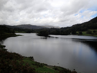
We crossed the River Rothay and headed through the woods to reach Rydal Water, where we found a pleasant flat area for a picnic about half-way along the southern shore, almost opposite a couple of small islands.  The weather remained dry and we had a pleasant lunch admiring the views across the lake (or water as Gordon corrected me, as there's only one lake in the Lakes!)

River Rothay
Rydal Water
After lunch we retraced our steps back eastwards along the lake for a couple of hundred metres before branching right and ascending through the woods to reach the end of a minor road.  We followed this for around 2km as it followed the river downstream.  As the road was prohibited for cars, except for access, the walk was relatively pleasant and Isabel was soon asleep on my back.

On the outskirts of Ambleside we crossed a very narrow humpback bridge and headed for the town centre through Rothay Park, where there was a strange cairn sculpture.  We returned to the car park at around 2pm and headed to the Rattle Gill cafe for tasty crumble before heading home.

Strange cairn in Rothay Park

Tuesday 20 September 2011

The Two Parks of Dunham

Distance 5km; with Isabel

The band of rain decided to move a bit slower than originally forecast, so it was a pretty miserable morning outside in Stockport; therefore we delayed our morning walk until the afternoon when it was forecast to be drier.  We had been to Dunham Massey many times with Isabel but we had always stayed inside the deerpark for our walks.  I had recently noticed that there was another neighbouring park called Dunham New Park that I decided to go and explore today with a walk taking in it together with Dunham Park.

I set off walking from the main NT carpark at around 2:30pm with Isabel in the rucksack carrier to avoid having to lift the pushchair over the stiles on the north edge of Dunham Park, which I thought would be quite tricky to do on my own!  It was dry but overcast as we walked past the front of the Hall and out into the deer park; however we didn't have to walk far to see deer as there were some right in front of the Hall!

Deer outside Dunham Massey Hall
We walked along Smithy Drive to the edge of the deer park, crossed the stile and wandered along the quiet roads towards Dunham Town from where we picked up a public footpath heading east through fields and scrubland.

The track to Dunham New Park
After around half a mile we reached the edge of Dunham New Park, which contained a golf course.  There were handy warning signs asking you to stick to the footpath due to the danger of flying golf balls, however they failed to actually signpost where the footpath actually went!  As the footpath wasn't evident on the ground, I decided that I would just head towards the next signs in the distance that looked like the blue warning signs, which did eventually lead to the edge of the golf course and the footpath through the woods back towards Dunham Park.

Handy warning sign!
Trees in Dunham New Park
We re-entered Dunham Park at the end of Charcoal Drive and then followed the path along the eastern edge of the park through the fenced-off areas, where the young trees were thriving out of reach from the deer.  It was turning out to be quite a pleasant Autumn afternoon and the oak trees were laden with acorns, which Isabel seemed interested in whenever I pointed them out to her!

Acorns in Dunham Park
Leaving the enclosed areas, we headed along Farm Walk to reach Island Pool where few ducks.  We then headed back past the Hall to return to the car shortly after 3:30pm.

Island Pool in Dunham Park
Dunham Massey Hall

Sunday 18 September 2011

Wildmoor and Errwood

Distance 5km; Ascent: 150m; with Lynsey & Isabel

After the washout of last Saturday and yesterday's rain, it was good to see that the forecast for this morning looked promising so we decided to head out for a morning stroll.  There was an interesting sounding walk in our Peak District ATP walks book near Errwood Reservoir, which we decided to do.  However due to it being graded 5 and the description of the route as muddy in places we opted to take Isabel out in the rucksack carrier rather than the pushchair for a change, especially as it had rained a lot recently.

We set off from the carpark on Goyt's Lane at around 10:30am and headed past a tarn onto the old railway line, under overcast skies, with Isabel in the rucksack.  The track was pretty good with good views across the surrounding moorland.  Soon the sun broke through the clouds and we reached a blocked off tunnel that marked the end of the good track.

Tarn by Goyt's Lane
View SW from from old railway line above Errwood Reservoir
Shortly before the tunnel we turned right at a newish looking signpost, headed through a gap in the wall and followed a pleasant grassy path down towards Wildmoorstone Brook.  After crossing a bridge the path became quite narrow as it traversed the hillside above the stream; we were glad that we had opted for the rucksack carrier as it looked like it would have been quite tricky with the pushchair!

On the way down to Wildmoorstone Brook
Wildmoorstone Brook
The walk down the valley was pleasant and the weather had now improved significantly.  Soon we reached a broader vehicle track at a bridge over the brook.  After a brief consultation with the map, we continued on the true right of the brook and followed it downstream to reach Errwood Reservoir, where there was a collection of bird feeders in just one of the trees by the path; perhaps the birds didn't like the other trees?

Bird feeders by Errwood Reservoir
Errwood Reservoir
After admiring the view across the reservoir, we started to ascend back towards the car along a reasonable track.  The ascent was hard work with Isabel on my back so we stopped for a quick breather about half-way up to admire the views.  The track soon levelled out and we reached the car shortly after midday.

On the way back up to Goyt's Lane from Errwood Reservoir

Tuesday 6 September 2011

A Windy Stroll in Delamere Forest

Distance 4.5km; Ascent: 50m; with Isabel

With gale force winds forecast for the hill tops in the Peak, I concluded that we'd better avoid the high ground today and instead try to seek out somewhere where it wasn't raining!  The forecast suggested that the rain would clear away to the east during the morning, so a walk somewhere to the west of home sounded like a plan!  There was a pleasant sounding walk around Delamere Forest in the Cheshire ATP walks book, which we had considered on the bank holiday weekend but we ended up going to Rivington Country Park instead, and it seemed to be an ideal option for the day and it may even provide some shelter!

It was raining when we left home this morning, but as we headed west the weather improved and other than the wind it was quite pleasant when we arrived at the Linmere car park, although the skies looked to be threatening rain.  I set off walking soon after 10:30am with Isabel in the pushchair and headed north over the railway line, before turning right onto a pleasant earthy track alongside several of the Go Ape walkways.

Earthy track through Delamere Forest past the Go Ape walkways
Soon we reached Blakemere Moss, where there were good views westwards across the lake and we continued along its windy eastern shore.

Blakemere Moss from the east
At the corner of the lake we headed uphill away from the water through mixed woodland on a gravel track before heading westwards up Hunger Hill.  After several well signed junctions we were soon on the broad track leading back to the railway bridge.

View across the forest from the track back to the railway bridge
We reached the car at around quarter to midday after a pleasant stroll of little over an hour during which we had only seen a handful of other walkers.  The route had been graded as a grade 3 ATP walk in the Cheshire ATP walks book, but other than the bumpy gravel track in places it seemed to be a relatively easy ATP walk.  And just as we started to drive home, the rain started, which was good timing :)