Showing posts with label Macclesfield Forest. Show all posts

Sunday, 8 January 2012

A Northern Circuit in Macclesfield Forest

Distance: 6km; Ascent: 230m; with Lynsey & Isabel

I was keen to get out for a walk today, having spent yesterday at work, and the weather looked reasonable for this morning, but it was forecast to get wetter after lunch.  So we headed off to Macclesfield Forest for a morning stroll in the woods.  We parked near the Leather's Smithy and set off walking at around 10:15am under overcast, but dry skies.  We headed up the minor road, away from the reservoir, with me carrying Isabel in her rucksack carrier.

A bizarre dead-end footpath to nowhere!
Soon we came across a public footpath sign, complete with an A4 notice about the route informing us that the footpath didn't actually go anywhere and just ended in the middle of some fields.  Luckily this wasn't our planned route, so we continued to follow the red waymarked route up the minor road and then onto a broad forest track.

At the start of the forest track
Walking along the track through upland forest with a heavy load on my back reminded me a bit of sections of the forests on some of our previous TGO Challenge routes, especially around Fort Augustus.  We continued to climb along the track, passing several groups of mountain bikers, before reaching a junction where we left the broad track and turned right onto a narrower footpath through the woods.

Ruin at track junction in Macclesfield Forest
The gradient soon increased now we were no longer on the forest track, and we soon had to stop for a drink of water!  It soon became much darker as the path entered a much denser area of trees.  However after a few hundred metres, we emerged into a more open area of woodland.

A more open section of woodland
The angle of ascent now eased as the path levelled out.  Then we rounded a corner and were presented with a fully decorated Christmas tree in the middle of the forest!  On closer inspection, it would seem to have been decorated by a local walking group.

Christmas Tree!
Soon we reached the highest point of today's walk, where we met a broad track coming in from our left.  The water droplets in the cloud were not very far above us at this point and they chose this point to start to fall down upon us as drizzle.

Track near the high point of our walk
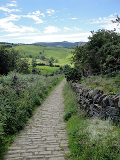
We followed the track to a small hamlet, where we turned right along the road for a short distance, before turning left again onto a footpath.  Shortly afterwards we left the red route, which we had been following thus far, and headed downhill to meet the Bollin Brook and the road.

Bollin Brook in Macclesfield Forest
We followed a series of footpaths alongside the road to the visitors' centre and then along the length of Ridgegate Reservoir to return to the car at around 12:15pm.  It had been a pleasant morning's walk, although we were glad to be heading home as the weather had now taken a turn for the worse!

Sunday, 24 July 2011

Shutlingsloe

Distance 5.5km; Ascent: 230m; with Lynsey & Isabel

The weather this weekend was significantly better than last weekend, which had been a washout, so we decided to take Isabel out for a hill walk this morning.  Our choice of hill was Shutlingsloe, which is a shapely small hill just to the south of Macclesfield Forest.

We set off walking from the Trentabank carpark at around 10:30am under overcast skies and started to ascend gently up through the forest on good tracks.  After about half an hour we left the forest and continued on a slabbed path towards Shutlingsloe with occasional sunshine.  We reached the summit of Shutlingsloe (Dewey, HuMP) at 11:15am where we admired the views across to Shining Tor; however we didn't linger too long as it was quite windy up there with little options for shelter with Isabel in the rucksack carrier.

We returned back to the forest by our route of ascent and took an alternative track back to the carpark, which we reached at around midday, where we enjoyed ginger beer and ice cream :)

Sunday, 26 June 2011

Tegg's Nose Trail

Distance: 4km; Ascent: 200m; with Lynsey & Isabel

Will the weather forecast promising temperatures of 27°C, we opted for a walk in the relative cool of the morning; although having said that it was still quite hot!  We had decided on a 4km circuit of Tegg's Nose, which we hadn't been to since walking the Gritstone Trail back in early 2008.

We set off walking from the visitors' centre shortly before 11am, having been delayed by lots of traffic jams on route.  There were good views across to Shutlingsloe as we descended down a stone track and then skirted the eastern side of the hill to reach Tegg's Nose Reservoir.  From here, there was a section of steep ascent through the woods before we reached the more level path near the top of Tegg's Nose.

The views were good from up here as we walked past the some of the preserved old quarry equipment.  The whole area at the top of the hill was covered with heather and bilberry with the occasional foxglove, so there were plenty of purple flowers around.  Some people appeared to be bilberry picking, although I didn't actually see any ripe berries myself.  We returned to the visitors' centre at around 12:30pm, where we enjoyed ice cream in the shade before heading home.

Saturday, 21 May 2011

Macclesfield Forest

Distance: 6km; Ascent: 240m; with Lynsey & Isabel

As the forecast was significantly better for today than tomorrow, we opted to go walking with Isabel today.  Lynsey had never been to Macclesfield Forest before and there was a route there in our Peak District ATP guidebook so we headed there for the day.

At the Trentabank Reservoir car park we enjoyed cake from the snack van before setting off walking at around 11:30am.  The guidebook handily informed us that we should follow signs for "Forest Walk 2", but this didn't seem to exist; there was however a "Blue" route that seemed to be the correct route so we followed that instead.  The ascent soon began as we climbed up the forest tracks towards Shutlingsloe.  After a while we reached a locked gate with a kissing gate next to it, which was unfortunately too small to fit the pushchair through.  Therefore we had to remove Isabel from the pushchair whilst I lifted it over the gate.

Eventually we reached the end of the ascent and continued along a reasonably level section of forest track with occasional views across to Tegg's Nose.  Soon we were on the edge of the forest and had excellent views across to Shining Tor and neighbouring hills.  Upon reaching the road, we turned left and followed it as our book advised that the next section of path was tricky with a pushchair (and there was also a further narrow kissing gate).

After a few hundred metres of road walking we rejoined the waymarked route where it crossed the road; however the gate here was too narrow for a pushchair so we had to lift the pushchair over a low fence to gain access to the path.  After a short distance we turned left over a small stream and continued downhill on a rough track, which was the roughest section of path all day.  Upon reaching the road again we were faced with a narrow gap stile in the low wall, which once again required the pushchair to be lifted over.

There was then a short section of road walking before we were able to rejoin the forest walk at a gate.  We then followed the waymarked path back to the car park.  It had been an enjoyable walk, although it was somewhat trickier than we had expected from reading the description in the Peak District ATP book, although this could have been due to changes to the forest walk since the book was written.  However after the walk I read the description for the essentially the same walk in the Cheshire ATP guidebook and discovered that is was graded 5 rather than 2 in the Peak District book and it handily mentioned the various obstacles too.