Saturday 31 March 2012

A Circuit of the Stretton Skyline

Distance: 28km; Ascent: 1350m; Overcast with occasional drizzle and a cold light wind; Solo

Lynsey's Shropshire backpack earlier this month had reminded me that I would like to go and explore those hills myself sometime.  So having discovered that Church Stretton is only 1 hour and 20 minutes away by train, I planned a long day walk to take in the majority of the Stretton Hills.  Therefore after catching an early train from Stockport this morning, I set off walking from Church Stretton station at around 8:15am after a quick breakfast of Eccles cake and milk from a nearby garage.

View NE back towards summit of Ragleth Hill
The recent spell of dry sunny weather had unfortunately come to an end, with the sky completely overcast and the cloudbase was at around 450-500m.  After crossing the A49, I began to ascend first through a housing estate and then on a footpath rising steeply through the woods.  Eventually the angle eased and I was soon walking along a pleasant grassy ridge to the sound of birdsong.  I reached the summit of Ragleth Hill (HuMP), my first hill of the day, at 9am.  There were good views across to the Long Mynd from here, and I could easily pick out my planned ascent route.

The Long Mynd and Little Stretton
After a few more hundred metres of ridge walking, the ridge abruptly ended and there was a steep descent down to Little Stretton and the busy A49.  The village pub looked temping as it proclaimed to sell Wye Valley beer, which from past experience is very tasty!  However it would have to wait as I still had a long way to go, and besides it was only 9:30 in the morning!

Small Batch corrie
I left Little Stretton past a small campsite, which seemed to be quite popular this weekend, and started climbing on a good path above the valley and corrie of Small Batch.  After skirting round Callow and Grindle, the ground eased and there was minimal ascent as I skirted Round Hill to pick up a wide grassy path through the heather.  Soon I reached the minor road that runs along the Long Mynd, which seemed to be very quiet today.  After passing Pole Cottage, I forked left on a broad path to ascend to Pole Bank trig point on the summit of the Long Mynd (Marilyn, Dewey), which I reached shortly before 11am.

Summit of the Long Mynd
From the misty trig point I followed a broad well-maintained path north east and soon started to pass several groups heading the other way, the first other walkers I had seen since leaving Church Stretton.  After crossing the minor road, I continued to follow the Shropshire Way north east for just shy of a kilometre before forking off right onto another bridleway.  This next couple of kilometres was the busiest section of the walk, meeting several cyclists, many walkers and a couple of horse riders. 

The mist was slightly disorientating at times and I had to make sure that I didn't drop too far down into Jonathan's Hollow to avoid reaching the A49 too far south.  Instead I crossed a minor road just to the south of Plush Hill before continuing to descend the grassy hillside.  Soon afterwards I found a sheltered spot and stopped for a quick lunch of cheese and pickle rolls.

I soon left the open access area and began following footpaths across the farmland, interspersed with a level crossing across the railway line and re-crossing the A49 again.  At Comley, I began the ascend up the interesting ridge of The Lawley.  This was an interesting hill, which formed a well defined SW-NE ridge.  Once up on the ridge, I was intermittently back in the mist before I reached the summit of The Lawley (HuMP) at around 1:30pm, complete with a nearby weather vane and the remains of a trig point.

Weather vane on the summit of The Lawley
After a quick break out of the wind, I retraced my steps for just over a kilometre back to the road, which I then followed for a few hundred metres to reach the start of the path up my next hill, Caer Caradoc.  This began with the steep ascent of Little Caradoc, from whose summit there were good views ahead to Caer Caradoc, whose lower slopes were covered in sheep.

Caer Caradoc Hill
I pressed on to the summit of Caer Caradoc (Marilyn), which I arrived at around 2:40pm.  The summit was relatively flat, with several rocky outcrops dotted around so I visited them all just to be certain I had climbed to the highest point!  By now it was evident that I wasn't going to make the 3pm train, which to be honest I hadn't really expected to anyway!  So I stopped for a break in the lee of one of the rocky outcrops.

Summit of Caer Caradoc
The remains of an old hill fort were evident in places near the summit and it was also rumoured that there was a cave somewhere up here too, but I didn't go investigating.  I headed southwards along the ridge past several interesting rocky outcrops along with a paraglider that was complaining about the wind and hence was struggling to get launched.

Rocky outcrop on Caer Caradoc
I soon left Caer Caradoc hill and descended towards my final hill of the day, Hope Bowdler Hill.  I crossed a green lane before ascending up a good path to join the ridge just to the west of Willstone Hill.  The ground was easy going and I was soon on the summit of Hope Bowdler Hill (HuMP).

Summit of Hope Bowdler Hill
There was a pleasant ridge to the SW of the summit, which I followed for around a kilometre, before dropping steeply down to the road.  I opted to follow a minor road down into Church Stretton rather than the B4371, which was busy with little space for walkers.  I arrived in Church Stretton at around 4pm, with enough time to buy a paper and some cake before heading to the station for the journey back home.  It had been a very good day's walk, although it was a shame about the weather, and I definitely plan to return to the Shropshire Hills at some point.


Friday 30 March 2012

A Sunny Walk on the Howden Moors

Distance: 22.5km; Ascent: 820m; Mostly sunny with a cold light wind; with Kim

I had managed to book today off work so I could enjoy the current spell of sunny weather that we were having.  Kim was also off work too, so we decided it would be good to go walking somewhere together.  I had been keen to explore the moorland around the upper Derwent valley for a while and today seemed like an ideal opportunity given the lack of rain in the last week so hopefully the ground would be pretty dry.

View up the River Derwent from Slippery Stones
As it was a weekday we were able to drive all the way to the road end at Kings Tree near the head of Howden Reservoir and it was surprisingly chilly when we got out of the car!  We set off walking just before 10:30am, just as the sun was starting to break through the clouds.  After following the forest track up to Slippery Stones we picked up a path alongside the River Derwent.

River Derwent
After a couple of a kilometres walking we left the path and briefly followed a small stream northwards before steeply ascending up onto the windy moorland.  We picked a way through the deep heather to eventually ascend up to the summit of Horse Stone Naze (Dewey), which was crowned with an interesting gritstone summit tor.

Horse Stone Naze summit tor
As it was almost midday, we considered stopping here for lunch but it was quite windy and the only sheltered spot was in a peat bog!  Therefore we headed east towards some boulders that looked likely to provide some shelter, where we stumbled upon a sort of cave between some boulders that looked like a possible bivy spot.  Shortly afterwards we stopped for lunch in the sunshine in the lee of some rocks and around here we spotted a mountain hare, the first of four that we would see today.  We also saw many, many red grouse on the moors and a few small lizards too.

Crow Stones
After a reasonably leisurely lunch, we continued east across the moorland and soon picked up a vague path up to the strangely shaped Crow Stones.

Crow Stones
From the Crow Stones we headed east across the almost flat moorland to reach the trig point on Outer Edge, which had been raised up presumably so the surveyors could get a better view.

Outer Edge trig point
We continued across the moorland to the south-east to reach the trig point on Margery Hill and soon afterwards a small tarn.  Around here we saw our first other walkers of the day, several hours after we set off.

Trig point on Margery Hill
Small moorland tarn south of Margery Hill
We followed the path southward across the moor, whilst admiring the views across the large expanse of moor towards Bleaklow, to reach the small cairn marking the summit of Howden Edge / High Stones (Dewey).

Summit of Howden Edge / High Stones
Here we had a decision to make: did we head back to the car now, which seemed a bit early as it was only 2pm, or did we press on to Back Tor.  Given it had turned into such a nice afternoon, we decided on the latter and picked a route down Gravy Clough to cross Abbey Brook before picking up a good path and ascending up to the trig point on the summit of Back Tor (Dewey).

Back Tor trig point
After admiring the extensive views from the summit, including towards Sheffield in the distance, we decided it was time to descend.  We followed a good path past the viewpoint at Lost Lad and on down to meet Derwent Reservoir near Abbey Brook.  The forest track made for good progress as we headed back to the car, although we did decide to save ourselves a kilometre by crossing the River Derwent just above the reservoir instead of pressing on to the bridge, and we reached the car soon after 5pm after an excellent day's walk.

Upper end of Howden Reservoir

Sunday 25 March 2012

Two Crosses LDWA Challenge Walk

Distance: 28km; Ascent: 780m; with many, including John J, Viv, Martin, John B and Judith


John J had been in touch a couple of weeks ago asking if I fancied coming along on an LDWA challenge walk in the West Pennine Moors, organised by the East Lancs group.  I hadn't been on any sort of challenge walk for many, many years since I did the Dartmoor Ten Tors and the OATS walk several times between 1996 and 2000.  However after a quick look at the route, I decided that I would enter the reasonable sounding 18 mile route.

Alistair at Affetside Roman Cross
And so at 7am on the morning that the clocks went forward, i.e. less time in bed!, I was kindly picked up from home by John B and we drove to the start at Tottington Youth Centre, just NW of Bury, where we met John J, Viv, Martin and Judith along with many other walkers and runners.  We were near the back of the group when we set off walking at 8am and began ascending gradually through the fields to the west of Tottington to reach the first cross of the walk: the Roman Cross in Affetside.

Jumbles Reservoir
From the cross we descended west for around a kilometre and a half, before crossing the A676 and picking up a track alongside the eastern shore of Jumbles Reservoir.  Due to the lack of wind, the water was very still, which afforded good reflections of the trees on the banks.  At the northern end of the reservoir we turned left over a bridge to reach the B6391 and the first checkpoint at Turton Tower.

Elaborate bridge over the railway near Turton Tower
After passing the tower, which appeared to be covered in scaffolding, we crossed the Bolton to Blackburn railway line by an elaborate castellated bridge, before following the Witton Weavers Way for a couple of kilometres across the edge of the moorland.  We passed a few people standing around their landrover looking puzzled as they had managed to drive off the track into quite a large hole and had seemingly grounded it; one of them appeared to be on the phone arranging some sort of rescue!

Just after the dividing point for the 18 and 25 mile routes, we recrossed the B6391 and headed down to our second checkpoint at Turton & Entwistle Reservoir, where there was an impressively large array of food and drink available!  By now the day was getting quite warm and it was time to dig out the suncream and sun hut.

Turton & Entwistle Reservoir
After a good break, we crossed the dam and past the Strawberry Duck pub to re-cross the Bolton to Blackburn railway line and then descended into the woods at the head of Wayoh Reservoir.  From here we began our long ascent up to Bull Hill, initially by a muddy footpath, then road and track to reach our third checkpoint at Orrel Cote Farm.

We then crossed the moorland of Edgworth Moor to reach Broadhead Road, from where we continued on a further footpath and then a minor road to reach the edge of Holcombe Moor.  We crossed the reasonably level moorland for around a kilometre to reach the base of Bull Hill.  From here the official route skirted the hill to the north, but I was keen to nip up to the summit having checked earlier in the week that there was no firing taking place as it lies on an MoD firing range.  Therefore as no red flags were flying, we ascended up the twenty-five or so metres to reach the trig point on the summit of Bull Hill (HuMP).

Bull Hill summit
From the summit we descended following a small path to the east for a few hundred metres, before meeting the main north-south track across Holcombe Moor.  Here we realised that we had missed the checkpoint by around half a kilometre!  Therefore we headed north along the track, i.e. the wrong way!, to reach the checkpoint, which seemed to have a reasonably well stocked bar!  However due to the heat, we all stuck to the water and jelly babies!

Pilgrims Cross Pilgrims Cross
We retraced our steps southwards past Bull Hill to reach the second cross of the walk: Holcombe Moor's Pilgrims Cross, where a couple of walkers were enjoying a refreshing beer in the sunshine.  There was a refreshing gentle breeze on the moor, but it was still very hot for the time of year!

View back towards the Pilgrims Cross on Holcombe Moor
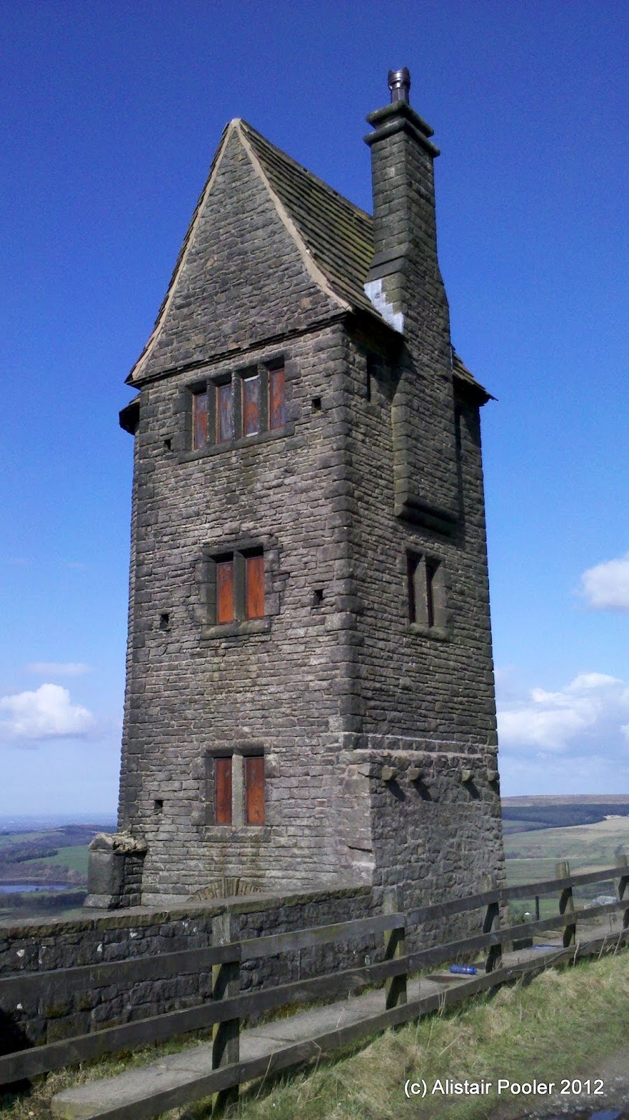
Our route lay southwards over Harcles Hill, from where there were good views back northwards over the moorland and the steep southern edge of Black Moss.  After descending into a small dip, we skirted the next hill to the east to reach Peel Tower, which was a very popular place to be today and there were some enterprising people selling cakes and drinks outside the tower.

Peel Tower
We descended down the hillside to enter Redisher Wood, where the ground steepened before reaching a bridge over a stream in the bottom of the valley.  Here there were three horses dipping their feet in the stream and one of them was splashing a lot, presumably in an attempt to cool down!

Stream in Redisher Wood
From the stream we ascended briefly, before following tarmac tracks and then a footpath to reach the final checkpoint of the walk at Spenleach Lane.  We headed through farmland and through a golf course to reach Greenmount.

Greenmount Church
After passing the church in Greenmount, and then a pub, we picked up a disused railway line for our final leg back to Tottington.  This path was very popular with many people out enjoying the good weather.  We crossed a viaduct over a reservoir before returning to the Tottington Youth Centre soon after 2:30pm, which was 6 hours and 37 minutes after we left.  Here there was lots of food available and I had a large bowl of soup and a cup of tea.  It had been an enjoyable day's walk and I definitely plan to do some further walking with the LDWA at some point.


Update 01/04/12: Martin's excellent take on the walk can be found here and more details about the challenge walk can be found on the LDWA website (links also added at start of post too).

Saturday 24 March 2012

Alderley Edge to Hare Hill

Distance: 8km; Ascent: negligible (although ViewRanger claims 300m!); with Lynsey & Isabel


It was forecast to be a lovely day so it seemed a shame not to go out for a walk and there was a nice sounding circular walk between Alderley Edge and Hare Hill that I had been thinking about doing for a while.  Therefore at 9:30am we set off walking from the car park at The Wizard tearoom with Isabel on my back in her rucksack carrier.

View from Stormy Point at Alderley Edge
Initially we wandered through the woods to Stormy Point to admire the view, although it was quite hazy today.  From here we wandered SE and then NE through the woodland before crossing a small stream.  We then ascended through the Beech Cathedral, where the trees were very tall!

Some of the trees of the Beech Cathedral
The woodland made for very pleasant walking as it wasn't overly dense like Forestry Commission woods can often be and some of the trees were beginning to grow new leaves.  It continued to be very sunny and it began to get quite warm, even in the shade of the woods.

Woods between Alderley Edge and Hare Hill
New leaves
After passing a small lake and crossing an area of parkland we reached the gardens of Hare Hill, complete with several wooden hares.

A hare at Hare HillAnother hare at Hare Hill
The lawn of the large walled garden was a very pleasant place to take a break from our walk whilst Isabel had a good wander around looking at the flowers and being intrigued by the croquet and badminton equipment.

Hare Hill walled garden
After a picnic snack in the walled garden we continued our circular walk by following the main driveway almost to the road, before picking up a footpath along the edge of the parkland next to the road for a few hundred metres.  We were then on the minor road for a short while, before picking up the track towards Adders Moss Farm.

Daffodils at Hare Hill
We followed the track for just over half a kilometre, before turning left onto another footpath back to the car park, where we arrived at around half past midday after a pleasant morning's walk.  As the weather was so nice, we sat outside the tearoom for lunch before heading home.

Sunday 18 March 2012

Rivington Pike

Distance: 4km; Ascent: 170m; with Isabel

Lynsey was away for the weekend backpacking in the Shropshire Hills, so I decided to take Isabel out for a morning stroll.  The overnight rain was forecast to clear from the north, so I opted for a trip to the West Pennine Moors.  We had previously been for a wander around the Rivington area with the pushchair back in August, and I had planned to revisit a couple of weeks ago with Martin but I unfortunately was unable to make it, so this seemed like a good opportunity to return.

Fancy bridge in the Chinese Garden
So after the 40 minute drive north from home, I set off walking from the upper car park with Isabel in the rucksack carrier and headed uphill under the fancy bridge to reach a pleasant small lake in the remains of the Chinese Garden.

Small Lake in the Chinese Garden at Rivington
Soon afterwards we joined a broad cobbled track, which gradually climbed in a zig-zag, past some inquisitive horses, to reach a further track junction.  Here we turned right and headed SE for around 100m along a green lane before turning sharp left and ascending up the heavily eroded path up to the top of Rivington Pike.

Isabel was fascinated by these horses near Rivington Pike
On the way up to Rivington Pike
The top of Rivington Pike is crowned by a stone tower, which was apparently built in the 18th century as a hunting lodge.  There were many people out walking today, with several groups on the top of the pike when we arrived, which is hardly surprising given the excellent weather today.

Rivington Pike Tower
The views from the top of Rivington Pike were excellent in all directions, from the moorlands and TV transmitter of Winter Hill around to the chain of reservoirs in the valley below.  I had forgotten my camera today, so the views provided an excellent opportunity to try out the camera on my new phone, which seems to have produced surprisingly good photos.

Winter Hill from Rivington Pike
View NW from Rivington Pike
After admiring the views whilst Isabel toddled about on the summit, we descended down the steps to the NW to return to the green lane, which we followed past the pigeon tower to reach the car park at around 11:45am after a good morning's stroll.

Rivington Pigeon Tower

Sunday 4 March 2012

Offa's Dyke Path - Day 5: Llanymynech to Welshpool

Distance: 20km; Ascent: negligible; Solo

Today's section of the Offa's Dyke path was not one that I was particularly inspired by as it is entirely flat, mostly alongside a river and a canal, with no hills to climb.  However most long distance paths seem to have their less good days, and at least I should be able to make quick progress :)

I felt much better this morning after a good night's sleep and, after a big breakfast, I was raring to go! The overnight rain had yet to clear completely so I was wearing full waterproofs when I set off walking at 8:15am.  I retraced my steps from yesterday for around 100m, before picking up the Montgomery Canal towpath.

Carreghofa Locks
The rain soon eased and there was a dusting of snow on the hills in the distant south.  The canal side walking was pleasant enough, although it was clear that the canal was no longer navigable as it disappeared for a few metres at some of the road crossings.  I passed the attractive Carreghofa Locks before crossing the River Vyrnwy on an aqueduct.  I continued to follow the canal for around another kilometre to where the onward route parted company with the canal; here I had a brief rest on a conveniently sited bench.

Pont-y-Person: where the Offa's Dyke Path leaves the canal
The main A483 road had been re-routed since my map was printed, but there were plenty of waymarks to direct me through the smart new subway and along the now old road into the village of Four Crosses.  From here I picked up Offa's Dyke again, which I followed for the next few kilometres to reach the Severn Way and shortly afterwards the River Severn.

Offa's Dyke south of Four Crosses
I followed the Tirymynach Embankment, built as a flood defence, for the next five or so kilometres with views across to the Breidden Forest and getting occasional glimpses of the River Severn.  The ground was firm and grassy, which made for easy walking and I reached Pool Quay shortly after 11am.  From here I picked up the Montgomery Canal again, which I was to follow all the way to Welshpool.

River Severn from the Tirymynach Embankment
Lone blackthorn tree
Breidden Hills from Tirymynach Embankment
Having seen almost no other walkers since setting off the morning, I now began to see occasional other people as I neared Welshpool.  Around midday the sun came out and it stayed sunny for the rest of my walk.  Once in Welshpool, I left the canal to wander through a housing estate and past a Tesco to reach the station at 12:45, in plenty of time for the one o'clock train home.

Montgomery Canal near Welshpool
It had been a good few days walking, covering a wide variety of different terrain and scenery, and today's walk had been better than I had expected.  At some point I shall return to Welshpool to continue the Offa's Dyke path southwards, but I'm not too sure when at the moment.

Photos and route maps will follow in the next few days...