I'm currently sat on a train to Knighton, from where I'll shortly be starting to walk south on the Offa's Dyke Path for 3-4 days. The plan at present is to walk to Kington today and then onto Hay-on-Wye tomorrow. Then ideally on Sunday I'll walk over the Black Mountains to Pandy, but I'll wait and see what the snow conditions are before finalising my onward route from Hay-on-Wye. All being well I should arrive into Abergavenny sometime on Monday.
Friday, 29 March 2013

Saturday, 16 March 2013
A Short Wander Around Powis Castle Gardens
Saturday 16th March
On our way to meet friends in mid-Wales for the weekend we stopped off at Powis Castle, on the edge of Welshpool, for a short wander around the castle and gardens; nothing too strenuous as we were all recovering from a winter cold! Here's a few photos from the afternoon showing the good views, including across the Severn valley to the Long Mountain where I was walking two weeks ago on the Offa's Dyke Path.
N.B. 02/06/13 - Post date updated to actual date of walk, i.e. 16/03/13 (from 22/03/13)
On our way to meet friends in mid-Wales for the weekend we stopped off at Powis Castle, on the edge of Welshpool, for a short wander around the castle and gardens; nothing too strenuous as we were all recovering from a winter cold! Here's a few photos from the afternoon showing the good views, including across the Severn valley to the Long Mountain where I was walking two weeks ago on the Offa's Dyke Path.
 |
| Powis Castle |
 |
| Powis Castle Gardens |
 |
| The Long Mountain from Powis Castle |
Saturday, 9 March 2013
TGOC Spring Gathering: Kinder From Snake Pass Inn
Saturday 9th March 2013
A wander along the northern edge of Kinder before descending down Ashop Clough
Distance: 15km; Ascent: 550m; Light snow, low cloud with a bitter wind; with lots of TGO Challengers
Despite neither of us actually being on this year's TGO Challenge we decided it would still be nice to head over to the Snake Pass Inn for the Spring Gathering, especially as it's not too far from home. This year we booked a room for Friday and Saturday nights so we could both attend the meal. After a sociable Friday evening in the pub, I joined a large group of TGO Challengers at 10am on the Saturday morning for a walk along the northern edge of Kinder Scout from the pub.
We crossed the Fair Brook and began to climb roughly southwards, up into the mist and snow to reach the edge of the plateau, with some breaks on route to allow everyone to catch-up. After a bit of a wander along Seal Edge we stopped for a spot of lunch in the small amount of shelter provided by some of the gritstone outcrops.
There was a surprising amount of old snow remaining up here from the previous snowfalls, which was hard in some places, and soft and quite deep in others. After crossing the Fair Brook for the second time today, we reached Fairbrook Naze before continuing westwards along the edge. The windblown snow had created some nice patterns in the rocks and grass along the edge.
After reaching the western end of the edge we descended north-westwards to the junction of the Pennine Way and the Snake Path. Here we opted to descend directly back to the pub, by following the Snake Path down Ashop Clough.
Now that we were out of the cloud, the group gradually began to split up and I spent most of the rest of the walk chatting with Andrew and Carl. I had also not been this way myself before so it was nice to be walking somewhere new so close to home.
The valley became quite steep sided as we descended eastwards, with some views back westwards towards Kinder and Mill Hill. As I crossed Upper Gate Clough, I spotted something interesting a hundred metres or so upstream so I decided to go and investigate. It turned out to be some sort of measuring instrument, which was presumably measuring water flow in the beck.
The last kilometre or so was through the forest back to the pub, where I found Lynsey & Isabel waiting for me at around 4pm. That evening there was well attended sociable meal in the pub's function room, during which it started to snow. Here are some links to Martin's and Gayle's reports of the weekend, and many thanks to Alan for organising an excellent weekend :-)
N.B. 02/06/13 - Post date updated to actual date of walk, i.e. 09/03/13 (from 20/03/13)
A wander along the northern edge of Kinder before descending down Ashop Clough
Distance: 15km; Ascent: 550m; Light snow, low cloud with a bitter wind; with lots of TGO Challengers
Despite neither of us actually being on this year's TGO Challenge we decided it would still be nice to head over to the Snake Pass Inn for the Spring Gathering, especially as it's not too far from home. This year we booked a room for Friday and Saturday nights so we could both attend the meal. After a sociable Friday evening in the pub, I joined a large group of TGO Challengers at 10am on the Saturday morning for a walk along the northern edge of Kinder Scout from the pub.
 |
| Group of TGO Challengers by the Fair Brook |
 |
| Heading into the mist and snow |
 |
| Lunch in the mist |
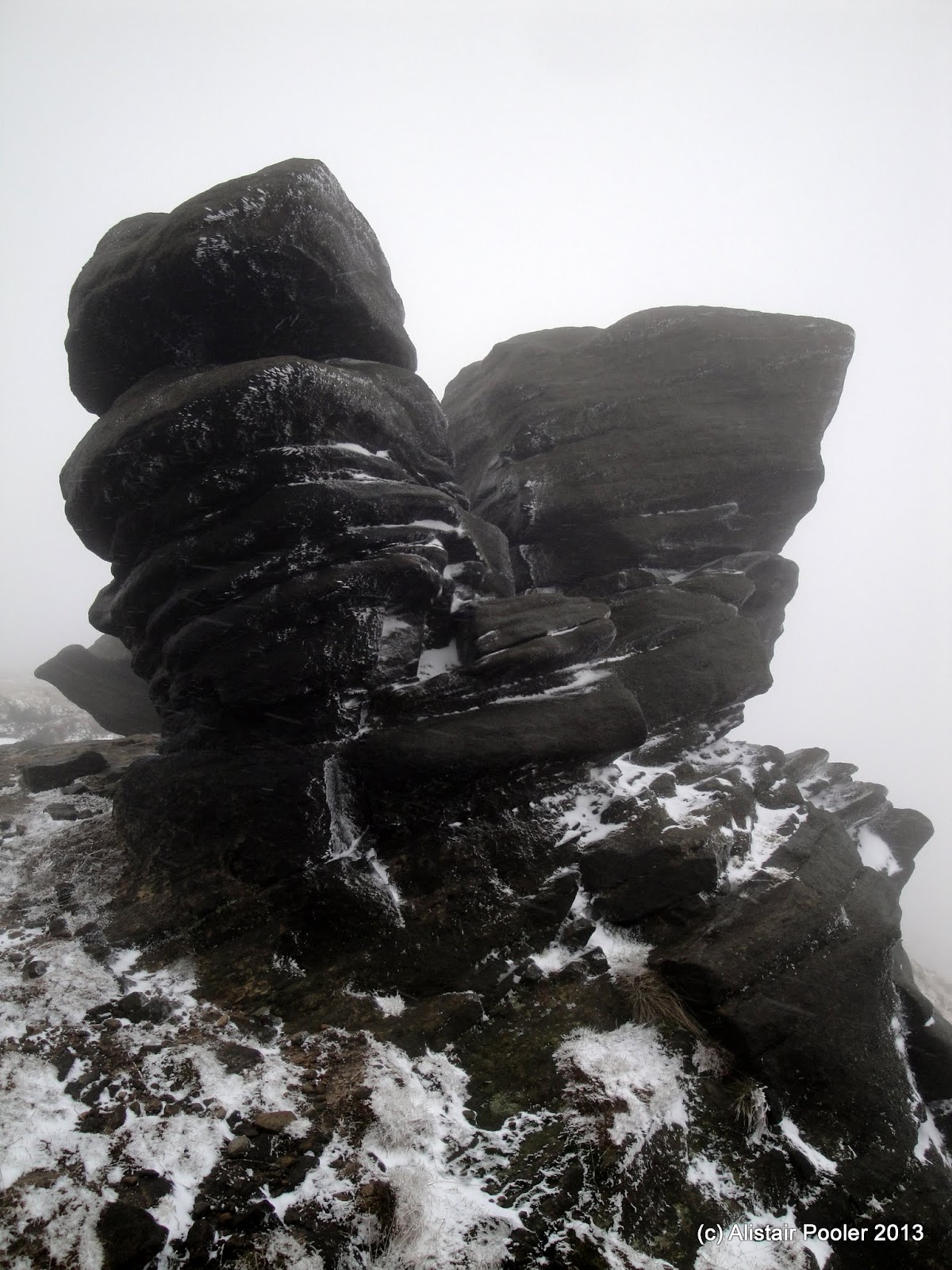 |
| Snowy rocks |
 |
| Snowy grass |
 |
| At the path junction above Ashop Head |
 |
| This way to the pub! |
 |
| On the Snake Path in Ashop Clough |
 |
| Ashop Clough |
 |
| Measuring instruments in Upper Gate Clough |
 |
| Sign at the east end of the Snake Path |
N.B. 02/06/13 - Post date updated to actual date of walk, i.e. 09/03/13 (from 20/03/13)
Tuesday, 5 March 2013
A Sunny Afternoon on Mam Tor
Tuesday 5th March
Here's a quick photo from our sunny stroll up Mam Tor yesterday afternoon. There were lots of paragliders out enjoying the weather and we watched several of them take off from Lord's Seat before flying past us on Mam Tor.
 N.B. 02/06/13 - Post date updated to actual date of walk, i.e. 05/03/13 (from 06/03/13)
Here's a quick photo from our sunny stroll up Mam Tor yesterday afternoon. There were lots of paragliders out enjoying the weather and we watched several of them take off from Lord's Seat before flying past us on Mam Tor.
 |
| Paraglider above Mam Tor |
Sunday, 3 March 2013
Offa's Dyke Path - Day 7: Mellington Hall Campsite to Knighton
Sunday 3rd March 2013
An early start for a tough day's walking crossing the many switchbacks in the Shropshire Hills
Distance: 24.5km; Ascent: 1250m; Overcast, cold with a bitter wind; Solo
I woke up at 4am this morning due to the cold and looking in the porch, my thermometer read -1°C. After opening the porch for an abortive attempt to make a cup of tea (I'd pretty much run out of gas!), the temperature in the porch dropped to -5°C! Whilst I had planned to have an early start today due to the very limited choice of trains home from Knighton, 4am was somewhat earlier than I had planned! Therefore after donning an extra layer, and spending 15 minutes or so by the warm heater in the toilet block, I went back to sleep for a little bit!
I packed my tent up just before dawn and set off walking around 6:40am. It was still bitterly cold with a hard frost on the ground as I continued southwards along Offa's Dyke. A short section of road walking followed before I returned to the fields for the first of many ascents today; this time up to the old drovers' road of the Kerry Ridgeway, which also marked the return to England and Shropshire (and the vast majority of today's lay on the English side of the border).
After a descent, another ascent and a further descent I reached the small hamlet of Churchtown, which was very quiet at this early hour of the morning! On the south side of the valley I joined the Shropshire Way, which ran concurrently with the Offa's Dyke Path for a couple of kilometres. It was still quite cold, with frost still on the ground, due to the sun not having broken through the clouds; however despite occassional glimpses of blue sky it remained cold and overcast all day.
After a further descent followed quickly by a re-ascent I reached a signpost that informed me I was now half-way along the Offa's Dyke Path :-) It had taken me 6.5 days walking to reach here from Prestatyn (over three seperate trips) and I was intending to take a further 6.5 days to reach Chepstow from here (although I don't currently know when I'm going to walk these sections!) Shortly after passing this signpost, I came to a handy water tap by the side of the path, provided by Severn Trent Water, so I stopped here for a bit of a rest.
By now it had begun to warm up ever so slightly as most of the frost had melted, although it remained cold. I crossed the Clun valley before beginning the longest ascent of the day up Llanfair Hill to the south. The first kilometre or so was the steepest and, after passing some very excitable dogs at Springhill Farm, I then had a gentle road walk for the next kilometre with good views of the dyke.
I turned off the road onto a pleasant byway, and it made a nice change to be walking on a decent track for once (and it would certainly help with my aim of making it to Knighton by 2pm!) Following the dyke this track took me over Llanfair Hill, and I had a quick detour to visit the trigpoint nearby. On the exposed high ground, the wind chill was quite noticeable and, whilst the views were good, I was glad to drop down into more sheltered terrain!
Clearly this was sheep farming country as all the fields were full of them as I descended down towards Selley Cross. Just one more ascent lay before me, and after ascending some very steep ground I reached the trigpoint on the summit of Cwm-sanaham Hill, from where there were good views.
After stopping for a quick lunch a short distance to the east of the trigpoint, I followed Offa's Dyke ESE towards Panpunton Hill with good views down to Knighton and the Teme valley.
A shortish steep descent brought me to the road, railway and the River Teme. The riverside walk into Knighton was pleasant and this time upon crossing the border there was actually a sign welcoming me to Wales!
On the way into town I passed the Offa's Dyke Centre, which would have been nice to visit but unfortunately it is closed on Sundays at this time of year and anyway I didn't have long until my train. I walked through the centre of Knighton past the clock tower to arrive at the station around quarter past two, i.e. in plenty of time for my train at 14:22, which was just as well as the next one wasn't for 4 hours! It had been a good couple of days of walking and it was nice to be out backpacking again :-)
N.B. 02/06/13 - Post date updated to actual date of walk, i.e. 03/03/13 (from 08/03/13). Links to trigpoints visited have also been added.
An early start for a tough day's walking crossing the many switchbacks in the Shropshire Hills
Distance: 24.5km; Ascent: 1250m; Overcast, cold with a bitter wind; Solo
I woke up at 4am this morning due to the cold and looking in the porch, my thermometer read -1°C. After opening the porch for an abortive attempt to make a cup of tea (I'd pretty much run out of gas!), the temperature in the porch dropped to -5°C! Whilst I had planned to have an early start today due to the very limited choice of trains home from Knighton, 4am was somewhat earlier than I had planned! Therefore after donning an extra layer, and spending 15 minutes or so by the warm heater in the toilet block, I went back to sleep for a little bit!
I packed my tent up just before dawn and set off walking around 6:40am. It was still bitterly cold with a hard frost on the ground as I continued southwards along Offa's Dyke. A short section of road walking followed before I returned to the fields for the first of many ascents today; this time up to the old drovers' road of the Kerry Ridgeway, which also marked the return to England and Shropshire (and the vast majority of today's lay on the English side of the border).
 |
| A frosty Offa's Dyke just south of Mellington Hall |
 |
| Crossing the border back into England and Shropshire |
 |
| Junction with the Shropshire Way |
 |
| The half-way point of the Offa's Dyke Path :-) |
 |
| A handy water tap provided by Severn Trent Water |
 |
| Offa's Dyke on Llanfair Hill |
 |
| Trigpoint on Llanfair Hill |
 |
| Trigpoint on Cwm-sanaham Hill |
 |
| Looking SE from Cwm-sanaham Hill |
 |
| Viewpoint over Knighton |
 |
| Crossing the border into Wales on the way into Knighton |
 |
| Knighton Clock Tower |
Saturday, 2 March 2013
Offa's Dyke Path - Day 6: Welshpool To Mellington Hall Campsite
Saturday 2nd March 2013
A pleasant ascent of Beacon Ring hill fort followed by a relatively flat walk south following Offa's Dyke across farmland
Distance: 24km; Ascent: 670m; Warm and sunny with little wind; Solo
It had been a number of months since my last backpack so I was keen to get out on a weekend walk. As it had been pretty much exactly a year since my last walk on the Offa's Dyke Path I decided to return to it. Therefore this morning I jumped on a train to Shrewsbury, where I picked up a few provisions before taking another train on to Welshpool.
It was sunny and warm for the time of year as I set off walking from the station at around 10am. The footpath I had planned to follow seemed less than obvious from the road so I instead followed the B4381 & B4388 roads for an extra kilometre. Then I was able to cut a corner using a public footpath before eventually rejoining the Offa's Dyke Path.
A steep ascent through fields followed as I began to tackle the only
significant ascent of the day. After a kilometre or so the angle eased
and I soon entered the woods past a large radio mast. A few hundred
metres further on I left the woods and found a sunny bench with a view
down to Welshpool. It seemed rude not to stop here, so I had a slightly
early lunch of wraps and Pyrenean mountain cheese!
After feeling suitably refreshed I headed deep into the woods, in the
enclosure of the Beacon Ring Hill Fort, in search of the highest point
of the hill. Soon I found the trigpoint and the nearby summit of Long Mountain - Beacon Ring (Marilyn).
It seemed strange having a
trigpoint completely surrounded by trees, but apparently they were
planted in 1953 to celebrate the Queen's coronation, which would
presumably have been some years after the trigpoint was built. This
site is well worth looking at on satellite images as the beech and conifer trees were clearly planted in a specific
pattern so that "ER" is spelt when viewed from above, as shown in the Google Maps image below:
Heading southwards back out of the woods, I rejoined the Offa's Dyke Path and gently descended to the SW before heading into the woods of the Leighton Estate; here I met my first other walkers of the day.
On the edge of the village of Forden I picked up the Offa's Dyke itself for a few hundred metres before returning to the road. After almost a kilometre of road walking I turned off down a farm lane to pick up the dyke again for the remainder of the day's walking.
After crossing the Camlad river, the dyke marked the England/Wales border for the next few kilometres with the path often switching sides, and every time I crossed into England there was a sign welcoming me to Shropshire.
I choose not to detour from the Offa's Dyke Path to visit Montgomery due to lack of time, and instead continued southwards along the edge of Lymore Park to eventually reach Brompton Crossroads and The Blue Bell complete with some rusting old petrol pumps outside.
My overnight halt lay a further kilometre or so along the trail, so I continued southwards through the pleasant Mellington Wood, where there were carpets of snowdrops next to the dyke.
Soon afterwards a track crossed the dyke, with a sign inviting walkers to visit the restaurant at Mellington Hall. After detouring southwards for a few hundred metres to investigate the start of tomorrow's route, I returned to this track and followed it to the Mellington Hall campsite where I had arranged to pitch my tent for the night. I arrived at the campsite around 5:15pm and found the reception closed, but I eventually managed to find the camping area and set up my tent in the last light of the day; I was the only person camping that night, presumably due to the time of year. I had an early start planned for tomorrow so after dinner I left my camping fee outside reception, returned to my tent, had a wee dram and went to bed shortly after 9pm after a good day's walk.
N.B. 02/06/13 - Post date updated to actual date of walk, i.e. 02/03/13 (from 07/03/13)
A pleasant ascent of Beacon Ring hill fort followed by a relatively flat walk south following Offa's Dyke across farmland
Distance: 24km; Ascent: 670m; Warm and sunny with little wind; Solo
It had been a number of months since my last backpack so I was keen to get out on a weekend walk. As it had been pretty much exactly a year since my last walk on the Offa's Dyke Path I decided to return to it. Therefore this morning I jumped on a train to Shrewsbury, where I picked up a few provisions before taking another train on to Welshpool.
It was sunny and warm for the time of year as I set off walking from the station at around 10am. The footpath I had planned to follow seemed less than obvious from the road so I instead followed the B4381 & B4388 roads for an extra kilometre. Then I was able to cut a corner using a public footpath before eventually rejoining the Offa's Dyke Path.
 |
| Back on the Offa's Dyke Path |
 |
| Welshpool from Long Mountain |
 |
| A handy bench for lunch on the edge of Beacon Ring |
 |
| Trigpoint on Beacon Ring |
Heading southwards back out of the woods, I rejoined the Offa's Dyke Path and gently descended to the SW before heading into the woods of the Leighton Estate; here I met my first other walkers of the day.
 |
| Beacon Ring hill fort from the SW |
 |
| Small lake in Leighton Woods |
 |
| Handy sign! |
 |
| Offa's Dyke near Forden |
 |
| This was carved into several of the signposts |
 |
| Tree just north of the Camlad |
 |
| Crossing back into Shropshire |
 |
| On the edge of Lymore Park |
 |
| Old petrol pumps outside The Blue Bell |
 |
| Snowdrops next to Offa's Dyke in Mellington Wood |
 |
| Heading through Mellington Wood |
N.B. 02/06/13 - Post date updated to actual date of walk, i.e. 02/03/13 (from 07/03/13)
Friday, 1 March 2013
Back to the Offa's Dyke Path
It's been pretty much a year since my previous walk on the Offa's Dyke Path, so on Saturday morning I shall be catching a train to Welshpool with the intention of spending a couple of days walking southwards to Knighton. My plan is to walk as far as the campsite at Mellington Hall on Saturday (22.5km, 580m), and then continue to Knighton on Sunday (22.5km, 1010m).
The following Social Hiking map shows my planned route (in pink), which should get overlaid with my progress (in orange) assuming that I remember to switch my SPOT on! There'll also be a blog post for each day when I get round to it!
See map on Social Hiking site or full size in a new window
The following Social Hiking map shows my planned route (in pink), which should get overlaid with my progress (in orange) assuming that I remember to switch my SPOT on! There'll also be a blog post for each day when I get round to it!
See map on Social Hiking site or full size in a new window
Subscribe to:
Posts (Atom)


