Tuesday, 14 May 2013

The Walk-in to Luib-Chonnal Bothy in Upper Glen Roy

Tuesday 14th May 2013 

A short evening walk into Luib-chonnal bothy to meet some TGO Challengers for the evening

Distance: 7km; Ascent: 150m; Overcast and mainly dry; Solo

Route map will follow next week

As I drove away from Newtonmore this afternoon I passed several TGO Challengers on the A86, including Ian C who I stopped to chat to for a few minutes.  My destination for the evening was Luib-Chonnal bothy in Glen Roy and I had decided to drive round to Glen Roy rather than approaching it from Melgarve as the Glen Roy approach is slightly shorter and has a better track most of the way.

At the end of the public road in Glen Roy I met Mike Knipe who I walked with for a few hundred metres before I realised that I'd left my gaiters in the car!  Given that the hills I had planned for tomorrow were quite peat haggy in places, I opted to return to the car to retrieve them!

Confluence of the rivers Turret and Roy
Bridge over the River Turret
I set off again from the car at quarter past six up Glen Roy at a fast pace.  It was mainly overcast but at least it was dry!  And there were good views of my onward route further up the glen.

Glen Roy near Leckroy
Falls of Roy
Shortly before the Falls of Roy I past Mike who was setting up camp for the night down by the river.  I continued on up the glen and about 30 minutes after passing the Falls of Roy I came to this new-ish looking bridge across the river, which I guessed could be useful to me on a future TGO Challenge route.

New-ish looking bridge in upper Glen Roy
At around 7:30pm I reached the bothy after walking across boggy ground for the last few hundred metres.  There were no tents outside, so I assumed that everyone was inside the bothy.

Luib-chonnal bothy
I headed inside and found Andy, Andrew, Alan and Phil all sat round the wood burning stove upstairs in the bothy.  After having my dehydrated dinner we cracked open the supplies of wine, cheese and port that I had carried up the glen.  Later on Richard arrived at the bothy after having spent time up on the hills above Glen Roy.

The cheese & wine party in Luib-chonnal bothy
The six of us enjoyed a good sociable evening in the bothy and by the end of the evening my supplies were exhausted, which was good as it meant I didn't have to carry them back out again!

Edit 12/06/13: Alan and Andrew have now written up their excellent accounts of today, including the cheese & wine party; follow the links above to read them.  Also see here for my Social Hiking map from the two-day trip.

N.B. 18/06/13 - Post date updated to actual date of walk, i.e. 14/05/13 (from 18/05/13).  Link to social hiking also added.
 

Creag Dhubh above Newtonmore

Tuesday 14th May 2013

A short walk up a rocky peak with excellent views over the Monadhliath Mountains 

Distance: 5.5km; Ascent: 530m; Mainly dry but very windy; Solo

My original plan for today was to set off on a 2-day backpack up Creag Meagaidh and neighbouring peaks, with an overnight camp at Lochan Uaine just below The Window.  However the weather forecast did not look promising with gales and thundery downpours forecast for the high peaks.  Therefore I had been in touch with Alan & Andrew last night and arranged to meet them at Luib-chonnal bothy instead this evening.  As this was only a few kilometres away from the end of the public road in Glen Roy, I decided to head out for a short walk with a day pack before heading to the bothy later.

Primroses below the crags of Creag Dhubh
I set off walking in the rain at around 11am from the road near Lochan Uvie and began to ascend up a faint path below the crags.  The ground became steeper and more unpleasant as I ascended, although there was a lovely carpet of primroses around here.  Eventually the rain stopped and I reached the ridge line where I came upon a path and resolved that I would use that as my descent route later as I didn't fancy descending the steep, bouldery ground I had just ascended!

View west shorty after gaining ridge
SSW ridge of Creag Dhubh
The SSW ridge of Creag Dhubh gave a pleasant ascent with occasional sections of easy scrambling.  There were excellent views to the nearby hills, especially the Central Highlands and Creag Meagaidh.

Central Highlands and Creag Meagaidh from Creag Dhubh
I continued on up the ridge, where it was now quite windy - I was glad I wasn't on a higher hill today!  At around 12:30pm I reached the summit of Creag Dhubh (Graham), from where there were more excellent views, including across to the Cairngorms and into the nearby Monadhliath hills.

The Cairngorms and Strathspey from Creag Dhubh
Looking NW into the Monadhliath from Creag Dhubh
Looking SE from Creag Dhubh
Summit cairn on Creag Dhubh
I retraced my steps back down the SSW ridge, with good views down to Lochan Uvie far below.  Continuing on the path, I headed SW until I was beyond all of the large crags hereabouts.

Looking down on Lochan Uvie from SW slopes of Creag Dhubh
Then followed a pleasant descent into a small wooded coire, with good views of the impressive crags.  I reached the car around 3 hours after setting off after a pleasant short walk, and it was even sunny a lot of the time!

Wandering through the woods below Creag Dhubh
Creag Dhubh crags
After heading back into Newtonmore to buy supplies, I drove round to Glen Roy to walk in to Luib-chonnal bothy for a cheese & wine party that evening.  For more details, see this blog post.

See here for my Social Hiking map from the day's walk.

N.B. 17/06/13 - Post date updated to actual date of walk, i.e. 14/05/13 (from 18/05/13).  Links to social hiking and hill-bagging also added.
 

Monday, 13 May 2013

Silverbridge and Little Wyvis

Monday 13th May 2013

A morning walk up a Corbett before the storm breaks! 

Distance: 10km; Ascent: 640m; Sunny, rainy, snowy & windy; Solo


The forecast was not at all promising for today, with predictions of rain, hail, snow, storm force winds and thunder!  However it looked like the worst of the weather would arrive from around lunchtime onwards, so therefore I needed a relatively short walk for the day.  My only remaining Munro in this area is Am Faochagach, which either requires a river crossing to access or a much longer walk-in from Black Bridge.  A couple of walkers from the bunkhouse had crossed the river on Saturday and they said it was nearly waist deep then, and it’s rained a fair bit since then!  I didn’t fancy the longer route with today’s forecast and so instead settled on the Corbett of Little Wyvis as my objective for the day.

Silverbridge and the Black Water
Therefore shortly after 9am I set off walking from the forest walks car park at Silverbridge. There were impressive views of waterfalls on the Black Water as I walked across the modern road bridge to reach the start of my track.  After passing some farm buildings I began to gain height, with excellent views towards the Fannichs to the west.

Looking towards the Fannichs from the W slopes of Little Wyvis
Fresh snow on Little Wyvis
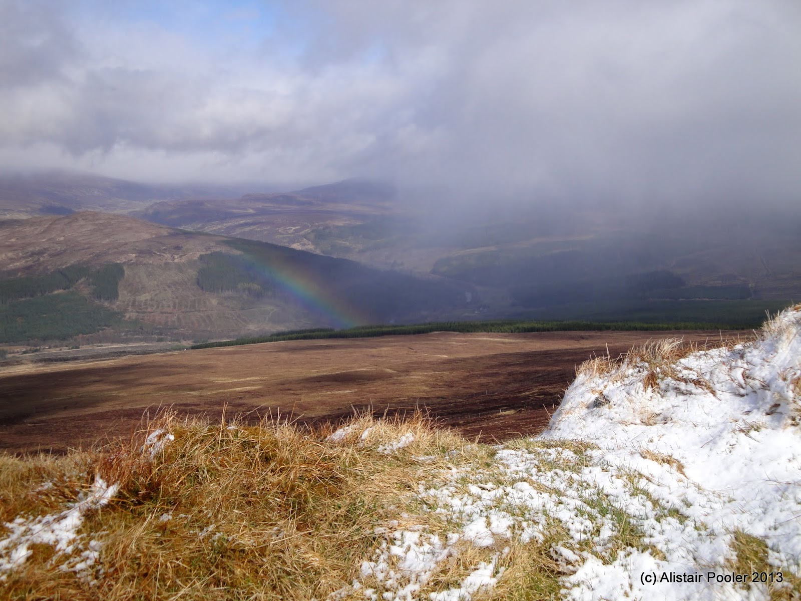
The vehicle track made for quick upward progress and I soon crossed the snowline at around 600m, with good views down to Meall Ruighe an Fhuruch and down into Strathgarve.  However the good views were not to last as over to the west I could clearly see the black clouds approaching, and soon the cloud began to lower.

Rainbow in Strathgarve
Meall Ruighe an Fhirich from upper slopes of Little Wyvis
I reached the summit of Little Wyvis (Corbett, Marilyn) at around 10:20am.  By now it was snowing, which together with the very strong winds produced blizzard conditions.  I was glad that I had chosen a short walk for today!

On the summit of Little Wyvis
Little Wyvis summit cairn
It continued to snow as I descended back down my route of ascent, although it turned to rain once I was down below around 600m.  The rain continued for much of my descent, but the sun did eventually come out when I was a few hundred metres from the car!  I took a short detour to get a better view of the waterfalls on the Black Water before reached the car just before midday.

The Black Water flowing under Silverbridge
The Black Water
See here for my Social Hiking map from the day's walk.

N.B. 17/06/13 - Post date updated to include links to social hiking and hill-bagging pages.

Sunday, 12 May 2013

The Eastern Fannichs

Sunday 12th May 2013

A long day over some very rough ground in the Eastern Fannichs 

Distance: 21km; Ascent: 1040m; Wet & windy after a dry start; Solo

I had two days of walking around the Inverness-Ullapool road and today was forecast to have the best weather (although it would still be wet at times!)  My two options for Munro bagging walks near here were the eastern Fannichs, as I still had two left to climb there, and Am Faochagach to the north.  I opted to spend the day in the Fannichs and therefore shortly before 9am I set off walking from the car at the west end of Loch Glascarnoch.

The route in the SMC Munro guidebook follows the boggy ground alongside the Abhainn an Torrain Duibh.  However I was enticed by an sign which intriguingly signposted a recommended route to Beinn Liath Mhor Fannaich by way of a forestry track on the east side of the burn.  Given that this was roughly the direction I wanted to head, I decided to check it out.

Looking north to the Beinn Dearg hills
There were good views north to the Beinn Dearg group of hills as I began to ascend on the good vehicle track through the woods, and soon I also got views of my hills for the day: An Coileachan and Meall Gorm, which were both currently clear of cloud.

Meall Gorm and Beinn Liath Mhor Fannaich
An Coileachan & Meall Gorm
After a couple of kilometres I came to a fork, with the right-hand fork signposted to Beinn Liath Mhor Fannaich by way of a footbridge.  I followed the track down into the glen to reach a sturdy bridge over the fast flowing Abhainn a’ Ghiuthais Li.

The Abhainn a' Ghiuthais Li
Lower of two bridges over the Abhainn a' Ghiuthais Li
Here I rejoined the route in the SMC guidebook and continued on a boggy path along the north side of the burn.  The vehicle track however appeared to ascend up the slopes of Creag Dhubh Fannaich, although it was not clear how far it went.  After a further kilometre and a half I reached a second footbridge over the burn.

Upper of two bridges over the Abhainn a' Ghiuthais Li
I crossed here and now had a bit of a decision to make.  I could either continue to follow the route in the SMC Munros book or I could opt for a bit more a circular walk; I went for the second option.  I had read about a faint path that ascends Meall Gorm from Loch an Eilein and therefore I decided to go and investigate that.  Initially there was a boggy path to follow along the south side of the Abhainn a’ Ghiuthais Li, however after a few hundred metres this seemed to peter out.  I crossed much rough heather and bog, together with a couple of burns, to eventually arrive at Loch an Eilein.

Loch an Eilein
From here I could clearly see the path ascending up the slopes to the west, so I decided to follow it.  The path appeared to be an old stalkers path that had perhaps fallen out of favour as it appeared to be little used but very well built!  There were good views down to Loch Li from here, and I could now see that the vehicle track I followed earlier in fact goes all the way to that loch and as far as I can tell it is not currently shown on OS maps.

Loch Li
Snow melt
As I gained height on the path a problem presented itself: the upper reaches of the path were covered in a large snow patch that appeared to still be corniced!  However the snow was not continuous, so I traversed west across some very rough rocky ground to avoid it.  I now ascended steeply across rocky ground, with occasional small snow patches – I was glad I had my ice axe with me!

Sgurr Mor from the steep N slopes of Meall Gorm
Eventually I reached the west ridge of Meall Gorm a few hundred metres away from the summit.  It was good to be on much less steep ground and I was soon at the summit cairn of Meall Gorm (Munro, HuMP), where I stopped for lunch whilst admiring the views.

On the summit of Meall Gorm
A rock a few metres away from the cairn appeared to be slightly higher to me, so I visited that before beginning to descend the east ridge.  After a few hundred metres I reached what the SMC guidebooks optimistically describe as a hut!

Stalkers' shelter on Meall Gorm
Looking towards An Coileachan
By now the rain had definitely set in, so I donned my waterproofs before heading over to the summit cairn on the south-east top (Munro Top).  By now the cloud had begun to cover the peaks and after dropping down to the Bealach Ban I ascended up the stony slopes to reach the summit cairn of An Coileachan (Munro, HuMP) at around 2pm.

Summit of An Coileachan
I took a brief break in the shelter afforded by the summit rocks before descending on a compass bearing down the north ridge.  After a while I dropped below the clouds and there was a good view of Loch Gorm below me.

Loch Gorm
I picked up a narrow path around the west side of Meallan Buidhe, but it petered out in the boggy ground further north.  Therefore I took a traversing line in a rough NNW direction to reach the Abhainn a’ Ghiuthais Li a short distance west of the upper bridge.  I crossed the bridge and retraced my steps back along the now boggier path to reach the lower bridge.

By now the rain was beginning to ease a little and become more showery.  I opted to ascend the 50m so that I could follow the vehicle track back north to the A835 road, where I reached my car just before 5pm after a long, but good, day on the hills.  Today also marked my completion of the section 14 of the Munros :-)

See here for my Social Hiking map from the day's walk. 

N.B. 16/06/13 - Post date updated to actual date of walk, i.e. 12/05/13 (from 13/05/13).  Links to social hiking and hill-bagging also added.

Saturday, 11 May 2013

An Afternoon Wander up Tinto

Saturday 11th May 2013

A quick nip up Tinto on my way north to the highlands 

Distance: 7.5km; Ascent: 470m; Windy with showers of rain & hail; Solo

Unfortunately I didn’t make it through the draw for this year’s TGO Challenge; however I decided to still head up to the highlands for a week of hill bagging and walking during the first week of the challenge.  As I didn’t set off from Stockport until this morning, it was always going to have to be a short hill today, and I fancied climbing Tinto above the Clyde valley.

The path to Tinto
Therefore at around quarter past one I set off walking from the car park on the edge of Fallburn following a broad track.  A shower had just finished passing so the cloud was gradually lifting off the upper slopes of the hill as I ascended.  In fact when I got a bit higher there was even some blue sky!

A Rare Bit of Blue Sky over Tinto
However it was not to last as the wind soon picked up and, as I was within a few hundred metres of the summit, a hail storm broke!  Therefore I didn’t linger long on the summit of Tinto (Graham, Marilyn, Donald) after visiting the viewfinder on the summit cairn and the nearby trigpoint.  Apparently on a clear day you can see Lochnagar from here according to the viewfinder; today however I could only just about see the trigpoint from the viewfinder!

Viewfinder on the summit of Tinto
Summit cairn and trigpoint on Tinto
I had originally considered descending by a different route so as to make a circular walk; however due to the hail storm I wasn’t overly inspired by this idea and instead choose to return the way I ascended with a slight variation around Maurice’s Cleuch.  I returned to the car shortly after 3:15pm after a good couple of hours walking.  Now it was time to drive north to the highlands :-)

See here for my Social Hiking map from the day's walk. 

N.B. 16/06/13 - Post date updated to actual date of walk, i.e. 11/05/13 (from 12/05/13).  Links to social hiking, hill-bagging and trigpoint also added.

Tuesday, 30 April 2013

A Short Wander around Hare Hill

Tuesday 30th April 2013

As it was such a lovely sunny day we decided to head to Hare Hill garden, between Alderley Edge and Macclesfield, for a short wander around with Isabel; here are a couple of photos of the nice walled garden at Hare Hill:

Hare Hill walled garden

Saturday, 27 April 2013

Seal Spotting on Kildonan Shore

Saturday 27th April 2013  

A short coastal wander on our last afternoon on Arran

Distance: 3.5km; Ascent: negligible; Sunshine and showers; with Lynsey & Isabel

It was our last day on Arran today and it was forecast to be the best day of weather so far, with unbroken sunshine forecast for the whole day!  We had heard that there was a nice coastal walk near Kildonan and so after packing the car and leaving the cottage we drove south.  After an early lunch we set off walking at around midday from the westernmost of the three car parks in Kildonan.

Looking west along Kildonan Shore
There were good views along the coast as we headed westwards, initially on a broad path before continuing across reasonably flat grassland behind the shore.  We spotted several seals basking on the rocks and swimming in the bay, along with a few oystercatchers, and here are the best photos of them I could manage with my compact camera:

Seals at Kildonan Shore
A Seal on Kildonan Shore
Oystercatchers at Kildonan Shore
We continued for a few hundred metres, past a small warterfall, with excellent views along the coast in both directions.

Looking west along Kildonan Shore
Waterfall above Kildonan Shore
There were also good views across the sea to the south towards the islands of Pladda and Ailsa Craig. 

Looking south towards Pladda and Ailsa Craig
At around the point that we decided to turn around we came across a small natural arch in one of the rocky promontories along this bit of the coast.

Small natural arch at Kildonan Shore
The sun was out as we retraced our steps eastwards, mainly sticking to the grass behind the shore itself as it was much easier to negotiate with the pushchair compared to the soft sand!

Kildonan Shore
Pladda from Kildonan Shore
We returned to the car at around 1:30pm and headed for tea and cake in a cafe in Whiting Bay, before driving north towards Brodick with excellent views of the northern hills.

The northern hills from the Lamlash to Brodick road
We left Arran on the 16:40 ferry in the sunshine after an excellent week :-)  We shall have to return another time as there was so much we didn't manage to explore during our week.

Our return ferry arriving into Brodick
Sailing away from Arran after a good week!

N.B. 11/06/13 - Post date updated to actual date of walk, i.e. 27/04/13 (from 09/05/13).