Sunday, 8 July 2012

SLMM 2012 - Day 2: The Return to Wasdale Head

Sunday 8th July 2012  

Distance: 17.2km; Ascent:790m; Mainly dry and overcast; with Mark
See approximate route in new window (checkpoints are shown as waypoints)

I woke at around 6:30ish due to the number of overly keen people already up and about, and was pleased to discover that it was dry outside :)  However the disadvantage of camping with so many other people was the seemingly endless queue for the portaloos in the morning!

As we hadn't finished within 45 minutes of the class leaders yesterday we would be taking part in the mass start between 8am and 8:30am (the fastest few teams in each class set off even earlier!), which meant that we didn't have to rush too much and had time for a brew :)  I wandered down to the start to pick up our list of controls for today's route and returned to the tent to plot them out on the maps at our leisure as today's clock had not yet started ticking!  I was slightly disappointed to discover that we wouldn't be returning over the hills on the south side of Wastwater, although the controls we had been given did look to form a reasonable route.

The Sunday mass-start
The organisers seemed very keen to continuously remind everyone who hadn't yet set off that the start closed in x minutes time, where x started at 15 minutes and gradually reduced as you might expect!  By the time we had finished packing up, x had reduced to 9 minutes and we were walking down the field to the start.

We officially started soon after 8:20am and headed for our first control of the day around a kilometre away to the south-east.  Whilst planning our route in the tent earlier we had decided not to follow the circuitous route of the forest tracks but instead to cut across country alongside the northern edge of the woods before following the river down to the bridge and our check point.  This also appeared to the be the approach of the vast majority of the other teams and to start with it all went well, if a little damp underfoot.

However the River Bleng proved to be about knee deep and most of the fell runners just waded it using the fence as a handrail.  But we decided that we didn't fancy getting our boots wet this early on in the day if we could help it and opted for a boulder hop across.  Mark went first but disaster struck around half way across when a suspicious looking rock turned out to be very slippery and there was a dramatic splash as Mark fell into the river!  However no harm was done and he was soon on the other side, if a little wet!  In the light of this I decided to modify my planned crossing slightly and accepted getting damp feet so that I could place them a bit more securely and successfully made it to the other side without falling in :)

Now all we had to do was follow the true left bank of the river downstream for around 200 metres to the bridge, but the route turned out to be an extremely damp peat bog that was over knee deep in places - lovely!  Check point visited we returned back the same way to the forest edge, which we followed SSE and soon picked up a forest track that made for easier, and drier, walking!

On the forest track near check-point 2
After around a kilometre of the forest track we found our second control of the day at a track junction where we turned left towards the hills.  This track ended after another kilometre leaving us with 150 metres of boggy fire-break to negotiate to reach the forest edge.  Here the ascent began, gentle at first, across damp moorland to reach our next check point by the cairn on Glade How (Birkett).

Ahead lay just under 300 metres of ascent, which would take us to our highest point of the day.  After a quick break on Glade How, we joined the seemingly never-ending stream of walkers heading up into the mist.  At around 10:20am we reached the summit of Seatallan (Nuttall, Marilyn, Wainwright, Birkett), where our fourth check point was located.

Descending Seatallan
A number of teams appeared to have resorted to much compass work to find the right way off Seatallan, however the route onwards seemed obvious to us and so we followed our noses and then the path down the north ridge of Seatallan and soon dropped out of the cloud.  Our next check-point was on the SE slopes of Haycock so we followed the clear path northwards across the pass and skirted a boggy area to the west before forking off right on a traverse to find the correct stream.

Upon reaching the stream the check point was nowhere to be seen.  After consulting our altimeters it became clear that we were a little too high and so followed the steam down for a short distance to find the control.  However a number of other teams just continued traversing the hillside; presumably they had decided that it was the wrong stream!

A short steep descent brought us to check point 6 at a sheepfold in the valley bottom, which was followed by a boggy traverse and short descent to reach a stream confluence where check point 7 was located.  The section between here and check point 10 covered some pretty horrible terrain with loose rocks covered in wet bracken, which hence made for some pretty slow progress.  However our poles were a godsend on this terrain and we overtook several other teams clad in fell shoes.

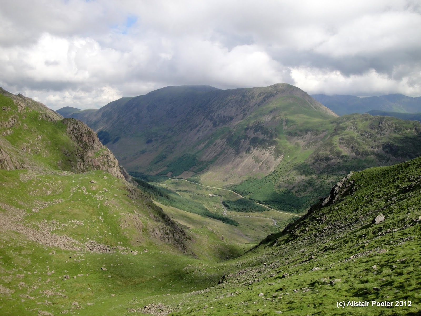
Wast Water
There were good views down the valley to Wast Water as we traversed the unpleasant hillside above Nether Beck to reach a wall; perhaps it would have been easier to follow the valley floor and then walk up next to the wall?  (and indeed this is what the planner's choice route showed after the event!)  Not to worry, we soon had check point 8 in the bag and descended down to cross Over Beck at a handy footbridge.

Over Beck
From here we had two uncrossable boundaries to deal with that we were officially only allowed to cross at the crossing points marked on the special SLMM map.  Therefore we had two options: either a steep ascent to reach a higher crossing point or a traverse to reach a lower crossing point (both options also involved further traversing to cross the second wall at its only crossing point).  We chose the second option, along with many other teams, and were somewhat disappointed to find that the crossing point didn't actually exist!  We were certain we were in the correct location, but there was no stile that we concluded that there would be at the official crossing point.

We could see a reasonable distance downhill and concluded that it wasn't there.  Uphill however we could spot the higher of the two crossing points marked on the map and opted to head for that one instead.  First wall out of the way, we descended to cross the second wall before traversing to reach a well concealed control at the base of a small crag.

On the home straight back to Wasdale Head
A slippery descent brought us to a faint path alongside a wall, which we followed north-eastwards for around a kilometre to reach our first manned check point of the route, which was also our last one.  Red and white tape now showed us the way to the finish, a little over 500m distant.  We ran the last couple of hundred metres, arriving at the finish by way of a little bridge over Mosedale Beck shortly after 1pm.

Day 2 times
The food tent beckoned and we joined the snaking queue, which went all the way around the inside of the large marquee!  Lunch consisted of some sort of multiple bean stew with pitta bread, followed by flapjack; all very welcome after two days on the hill, especially as I'm not really used to walking against the clock!  By now the results had been displayed on the tent wall and we discovered that overall we had finished 50th out of 101 finishers in our class with a time of 10 hours and 19 minutes, which we thought was pretty good considering our extremely limited amount of running over the two days :)

Our certificate :)
After lunch we wandered around saying our goodbyes to various people before heading back to Stockport, via Liverpool, for a roast dinner / curry with Gordon, Lucy, Mark and Lynsey.  All in all it had been an excellent weekend, especially as I didn't get anywhere near as wet as I might have expected from the forecast!

N.B. 30/10/12 - Post date updated to actual date of walk, i.e. 08/07/12, (from 16/07/12)

Saturday, 7 July 2012

SLMM 2012 - Day 1: Wasdale Head to the Midway Camp

Saturday 7th July 2012

Distance: 18km; Ascent:1130m; Sunny; with Mark
See approximate route in new window (checkpoints are shown as waypoints)

The luck of the draw had resulted in us having a relatively early start time of 8:58am this morning for our first ever mountain marathon.  We had entered the Wansfell class, which was pretty much the easiest class on which you were allowed to run if we wished.  After breakfast we struck camp and registered ourselves on the event, at which point Mark was given an SI card to attach to his wrist that would record our visits to each of the check points.

Setting off from Wasdale Head on Saturday morning
It was bright and sunny as we set off from the event centre at Wasdale Head at 8:30am for the "20 minute walk" to the start up in Mosesale as part of a steady stream of entrants, most of whom looked to be fell runners.  After 15 minutes or so, we got our first sighting of the start and it still looked to be quite some distance away!  Therefore we quickened our pace and made it to the start with 2 minutes to spare.

At our allotted time we passed through the start gate and picked up our list of check points for the day; this was also when we found out where we would be camping for the first time.  The clock was now ticking and so we could either opt to go directly to our first check point or spend a few minutes annotating our SLMM Harvey Map of the area with our check points for the day.  We opted for the later as it would save time later, and this appeared to be the approach of most of the teams who were busily scribbling on their maps in the sunshine.

Heading for the first check-point

Yewbarrow towering above Mosedale
The first check point wasn't too far away: a re-entrant on the way up Black Sail Pass and we were there around 30 minutes after starting.  There were good views from here back to the start in Mosedale.  We picked up the main path up to Black Sail Pass, but soon forked off right on a much fainter path that looked to take a more direct line up to our next control.  After much ascent we finally reached the summit of Looking Stead (Nuttall, Birkett) and found our 2nd control on it's north side. 
 
On Looking Stead heading for the 2nd check-point

The check-point on Looking Stead
The views from up here were excellent with good views across to many of the surrounding groups of hills, including those on the north side of Ennerdale.

High Stile and High Crag above Ennerdale
We headed west up the main ridge with the intention of contouring round to Wind Gap at some point.  However the ground looked quite rocky and we eventually decided that it would probably be quicker to go up and over Pillar.  We soon reached the trig point on the summit of Pillar (Nuttall, Marilyn, Wainwright, Birkett), where we had a quick break whilst admiring the views.

Summit of Pillar
The SW slopes of Pillar were mainly easy and grassy and we decided that as we were in a running class, we might as well do a spot of running!  The strange thing was that we seemed to be some of the only people running, and it seemed a little odd to be jogging past teams kitted out in fell running shoes!  However the running was short lived as the ground soon steepened and we were scrambling down the rocks to reach check point 3 in Wind Gap.

From here the only way was up and we ascended up the steep slopes to soon reach the summit cairn of Black Crag (Nuttall, Birkett).  After descending slightly to a pass we picked up a traversing path towards Red Pike, which we followed for a few hundred metres before cutting across country to the stream bend high on Scoat Fell, which formed our 4th check point.

We jogged down the gentle, but wet, slopes to reach Scoat Tarn where the crossing of the outflow seemed to be causing problems for some who were trying to keep their feet dry!  However we had no problems, as we used our poles for assistance, and soon reached our 5th checkpoint on the south side of the tarn.  From here it was a reasonable distance to our next one, with an intervening valley in the way!

After descending down into the head of the Nether Beck valley, we picked a traversing line up through the small crags to reach the boggy area of the Pots of Ashness below the north side of Seatallan.

Mark pointing to check-point 6 in the Pots of Ashness
Our 6th control was described as by a tarn, which as you can see above was not entirely obvious!  However the steady stream of people heading to a particular point in the boggy hollow strongly suggested that that was where the control point was!  And therefore we headed for it!

After crossing the pass to the west we began to descend towards the valley of the River Bleng.  Soon we found a few rocks to sit on and enjoy a 10 minute lunch stop, much to the amusement of passing competitors!  The descent proved to be quite steep through rocky and ferny ground; I was very glad of my poles!

The check point was not obvious from the descent as it was slightly hidden by a small hummock down by Tounge Gill - very devious!  Although we didn't really have any trouble locating it and were soon traversing the hillside to reach check point 8 by the waterfall on Red Beck.  From here we picked up a faint sheep path that traversed the hillside to reach the cairn on Hause, from where we could pick out the overnight camp in the distance.

Cairn on Hause prior to the boggy tussocks
The ground from here on was unpleasant consisting almost entirely of boggy tussocks!  This made for relatively slow going!  However eventually we reached our final control of the day, just on the edge of the forest at a track junction.  Now all we had to do was finish and there was a good track - even better!  We ran the last few hundred metres to the finish point and after checking in we were given the following printout of our times:

Day 1 times

It was now only 2:30pm and it was a little strange to be finished for the day so early!  But it was sunny :)  We set up camp in the increasingly busy field and set about having a relaxing afternoon :)  Given our relatively early start this morning, most of the people we knew were yet to arrive.  Gradually however they began to appear until by late afternoon we had quite a sizeable group consisting of Mark, me, Gordon, Lucy, Ian, Janet, Rich, Ben, Robin, Shayda and Jon.

The sunny mid-way camp
We picked up our beer, milk and soft drink order and sat around having dinner in the sun.  However the weather finally changed at around 7:30pm - it started raining!  And so we all retreated to our tent for an hour or two.  Eventually it stopped and we were back outside socialising.  I took a wander down to the results boards displayed at the finish to see how well we did today: we finished in a time of 05:29:14, which meant that we were 46th out of 109 finishers, which we were pretty pleased with!

N.B. 30/10/12 - Post date updated to actual date of walk, i.e. 07/07/12, (from 13/07/12)

Friday, 6 July 2012

Saunders Lakeland Mountain Marathon

This weekend Mark and I are taking part in the Saunders Lakeland Mountain Marathon, which this year is based out of Wasdale.  Therefore we are currently heading north on the M6 and hoping for good weather!  Although it currently looks like it's going to be wet!  Very wet!

We're doing the easiest course, which is the Wansfell Class and it should hopefully be good fun.  Due to the event rules I won't be able to take my normal phone (as GPS devices are banned) and therefore any blog posts will have to wait until I'm home again on Sunday...

Tuesday, 3 July 2012

On the Edge of the Peak District - A Circuit from New Mills

Distance: 32km; Ascent: 800m; mainly dry and overcast; Solo

With the Saunders now less than a week away, I decided that I should really get out for a long walk as it had been 4 weeks since my last hill-walk!  I had negotiated the day off from work and all I needed now was a plan.  With the forecast not sounding particularly pleasant for the high ground, I settled on a varied circuit from New Mills that would take in the Millennium Walkway, Lantern Pike, Coombes Edge, Werneth Low, Etherow Country Park and the Peak Forest canal; a significant amount of this would be new ground for me, which is always good!

Therefore I was up early today in time to catch the 7:02am train, which after 20 minutes or so deposited me at New Mills Newtown station.  I wandered down to a bridge over the River Goyt to reach the Millennium Walkway, which as its name suggests was opened in 2000 to provide a footpath link to The Torrs, suspended high above the river.

New Mills Millennium Walkway
I soon reached The Torrs, where there is one of the few outdoor climbing crags that stays dry in the rain (as it's underneath a road bridge!).  At the confluence of the rivers Sett and Goyt it was interesting to see that a small hydroelectric plant had been built since my last visit several years ago.  According to the information sign, Torrs Hydro as it is called is the first community owned and funded hydroelectric scheme.  It uses an Archimedes screw, nicknamed Archie, to generate the electricity and apparently it has generated 520,000 kWh of electricity since starting operation in September 2008.

Archie the Archimedean screw (inside the cage) at Torrs Hydro, New Mills
I continued to follow the path down the left bank of the River Goyt to reach the start of the Sett Valley Trail, a disused railway line that runs to Hayfield at the foot of the western slopes of Kinder Scout.  I followed it around two-thirds of the way to Hayfield before branching off left to follow the Pennine Bridleway as it ascended up the hillside on the north side of the valley.  After some steepness I reached the summit of Lantern Pike, from where the views were excellent!

Viewfinder on the summit of Lantern Pike
Just as I was about to leave Lantern Pike the sun broke through for the first time today and it remained sunny for much of the next hour of so as I followed the Pennine Bridleway northwards before cutting off left to reach Cown Edge and the start of another section of access land. 

Entering access land
Now I decided that it would be nice to walk along the top of Coombes Edge and given I was on access land I thought nothing about cutting across the moorland to reach it.  However when I did I found a barbed wire fenced barring me from accessing the path and I hence walked parallel to the path for a while hoping that I might find a crossing point.  I soon came to a fence junction, but all three fences were topped with barbed wire with no obvious crossing point and checking my map confirmed that every side of the three fences was since access land!  Having noticed that the second fence was incomplete in a couple of places all I had to do now was cross the first fence.  Remembering Alan's encounter with barbed wire a couple of years ago, I very carefully stepped over the fence at a lowish point and soon was on the path with no barbed wire related injuries to show for it :)

Coombes Edge
The path along Coombes Edge was pleasant with contrasting views north towards the Black Hill and Chew Valley moors and west towards the urban conurbation of Greater Manchester.  After following the edge to its end I descended on good paths surrounded by wild flowers to reach Charlesworth where there was a strange scarecrow in fancy dress outside the Methodist Church.  Now I've seen scarecrows in fancy dress before at the Kettlewell scarecrow festival but this one appeared to be all on its lonesome.

Wild flowers on the way to Charlesworth
A strange scarecrow in Charlesworth
After following the busy A626 for just over a kilometre, I turned right down a narrow lane followed by a steep woodland descent to reach a footbridge over the River Etherow.  Once on the far side, I began my final ascent of the day up through Back Wood to reach Werneth Low Country Park.  I've been here a couple of times before for pleasant strolls with good views of the West Pennine Moors and the Peak District; however today the rain threatened and I decided not to linger.  So, after a quick visit to the summit of Werneth Low / Idle Hill (HuMP), I picked up a good bridleway heading for Compstall.

Werneth Low
Summit of Idle Hill / Werneth Low
Soon it began to rain for the first time, but it only really drizzled for 15 minutes so I didn't bother with waterproofs.  And anyway it was one of those days when it was quite humid and I'd probably end up just as wet if I donned waterproofs!  After picking up a permissive footpath I soon reached Etherow Country Park and descended to reach the River Etherow for the second time today.

Weir on the River Etherow
After wandering alongside the river and lakes I reached the main road at Compstall, but luckily my onward route only involved a couple of hundred metres of road walking.  I picked up the Midshires Way, which I followed down to an Iron Bridge over the River Goyt, which was possibly the first cast iron bridge in the north-west when it was built in 1813 and apparently it is now of national importance as the only remaining iron bridge of its type in the north-west.

Brabyns Park Iron Bridge
After crossing Brabyns Park in the gathering gloom (although the rain never materialised), I picked a way up through the woods to reach the Peak Forest Canal just before it crossed the railway.  The section through Marple was quite impressive with a flight of 16 locks (although I had already missed the first four).  At the southern end of the locks I reached the junction with the Macclesfield canal on the edge of Marple.

Peak Forest Canal on southern edge of Marple
The trains back from New Mills only ran every hour and after consulting the map and the timetable I concluded that I could probably make the 15:50 train if I got a move on!  Therefore I walked quickly along the towpath of the Peak Forest Canal, with hardly any photo stops, and the tactic worked but only just as I only arrived on the right platform just as the train approached!  It had been a good and quite varied walk and I had managed it all without having to put waterproofs on, which was quite impressive given the weather forecast!

Saturday, 30 June 2012

A Long Weekend on Skye - Index

Bla Bheinn and Loch Coruisk
This year was the Queen's diamond jubilee year; this meant that the government had declared that we could all have an extra bank holiday in celebration, which was conveniently tagged onto the Spring bank holiday thus resulting in a 4-day weekend. What more excuse did I need to go hill walking in Scotland for a few days!!

I sought interest from various people and arranged to go away with Mark and Shona for the weekend. Due to the excellent weather forecast we settled on Skye, which I was very pleased with as I still had the northern half of the Cuillin Munros left to climb! We had quite a varied trip with two days scrambling in the Cuillin and two days backpacking in Trotternish. Many thanks to Mark and Shona for such an excellent few days in the hills! The good weather helped too!!

This post is an index of my blog posts for the individual days, some of which were written on my phone whilst on Skye (to which I've now added route maps and photos) and some of which were written up later due to lack of time...
All in all in was an excellent trip and I am looking forward to returning to Skye at some point in the next few years as I still have Bla Bheinn to climb, which looks awesome!!

Saturday, 23 June 2012

Around the Grounds of Kedleston Hall

Several weeks ago we had arranged to meet up with friends today for a pushchair / baby carrier walk, probably in the Peak.  However looking at the weather forecast yesterday evening it looked increasingly likely that it was going to be a washout.  Therefore Jim and I had a re-think yesterday evening and we decided to go to Kedleston Hall for the day as we knew that we would then have wet weather options should the pessimistic forecast turn out to be correct!

We arrived at around 11:15am and walked the first section of the "Long Walk" before retracing our steps to the pleasure grounds where we had a picnic lunch.  The grounds were indeed pleasant and we spent a while wandering around them, before a short stroll along the river followed by tea and cake.  All in all it had been a nice day catching up with friends, and it was even sunny at times, with almost no rain! 

Gates at the start of the "Long Walk"
Pond in the pleasure grounds
Kedleston Hall
Bridge in the grounds of Kedleston Hall

Sunday, 17 June 2012

Hardcastle Crags

Distance: 6km; Ascent: 200m; Dry with occasional sunshine; with Lynsey, Isabel, John, Steph, Sierra & Jack

It was dull and drizzly in Stockport this morning whilst we were getting ready for our exciting day out; we hoped that the weather would improve!  I had been thinking about going for a walk at Hardcastle Crags for a while and we had arranged to meet up with John, Steph, Sierra and Jack for a pushchair walk there today.

The weather improved as we drove north past Oldham and Rochdale and then along the never-ending road to Todmorden and Hebden Bridge, arriving at the Clough Hole car park a little after 11am.  The others had arrived just a few minutes before us and we were soon walking down through the woods on a reasonable path to reach the valley bottom and Gibson Mill - a former cotton mill built around the turn of the 19th century.

Gibson Mill
After crossing the bridge outside the mill we wandered around the mill pond before picking up the "Crags Constitutional" trail.  Initially this was on a broad vehicle track, which Isabel walked a lot of despite it being mainly uphill!  There was plenty to look at in these woodlands, including several wood ant anthills and small streams.  After a while we came to a fork in the track; we headed left, following a track that seemed to be almost directly above the river way down below to our left.  At the bottom of the hill we reached a further path junction and bridge; this was the turning point for the walk in our ATP walks book.  However we decided to keep going along the reasonable broad path to reach the cottage at Over Wood.

Burn near Over Wood
Here we left the woodland briefly and the sun came out so there were good views up and down the valley.  As the track up the valley seemed to deteriorate from here, we decided to retrace our steps back the way we had come towards the footbridge.

First footbridge over the Hebden Water
Upon reaching the footbridge it was decision time: did we return the way we had come or did we explore the far side of the river?  As it was still quite early in the afternoon we opted for the later option, thinking that we could always retrace our steps should we come across any insurmountable obstacles with the ATPs.

A carpet of leaves
The path followed the river closely for much of the way switching sides a couple of times (aided by handy footbridges!).  For much of the way the terrain was relatively easy through the woods, even on a paved path at times.  However there were several trickier rocky sections, which definitely required two people to negotiate.

The good section of path winds its way through the trees
Eventually we reached another mill pond, whose water was almost perfectly still due to the complete lack of wind.  This also meant that there were a lot of midges around, of which several hundred managed to steal some of my blood!!  The weir just beyond the far end of the mill pond seemed to be quite fast flowing today.

Mill pond near Gibson Mill
Weir on the Hebden Water near Gibson Mill
Soon we were back at Gibson Mill, where we stopped for tea, cake and ice cream outside the cafe in the sunshine before heading back up the extremely long hill to the car park, arriving around 5pm.  It had been a lovely day's walk with friends :)

Gibson Mill
Tolls, but what does a pushchair cost?